Map of Darke County - Darke County is a county located in the U.S. state of Ohio. Darke County Map showing cities, highways, important places and water bodies. Get Where is Darke County located in the map, major cities in Darke county, population, areas, and places of interest.
Map of Darke County, Ohio
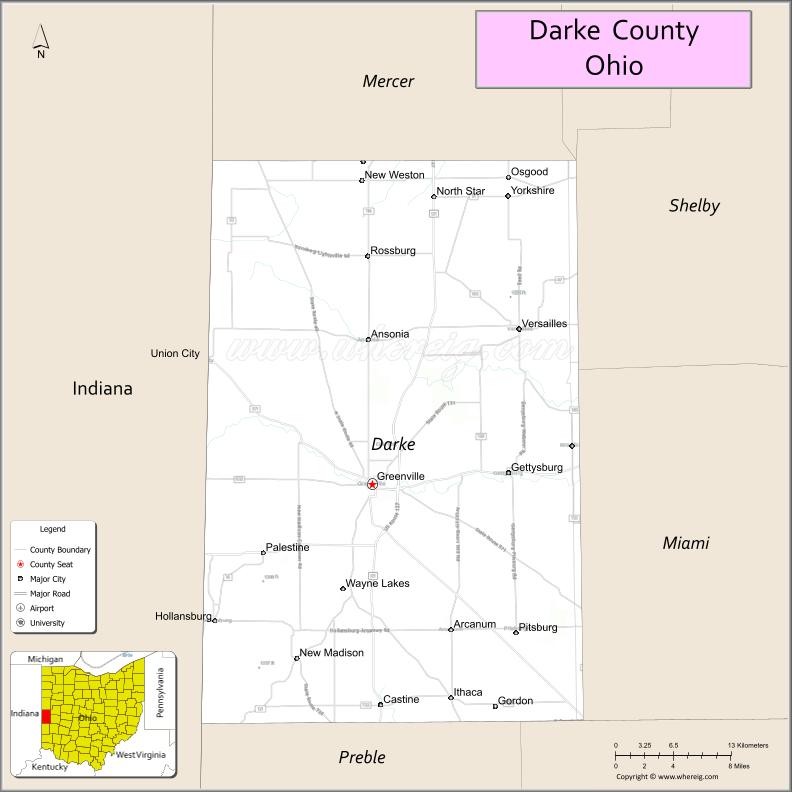
About Darke County Map, Ohio: The map showing the county boundary, county seat, major cities, highways, water bodies and neighbouring counties.
Ohio More Maps & Info
About Darke County, Ohio
Darke County is a county located in the U.S. state of Ohio. It's county seat is Greenville. As per 2020 census, the population of Darke County is 51597 people and population density is square miles. According to the United States Census Bureau, the county has a total area of 599.80 sq mi (1,553 km2). Darke County was established on -33233.
Darke County Facts
| Continent | North America |
| Country | United States |
| State | Ohio |
| County Seat | Greenville |
| Largest City/Town | Greenville |
| Established | 1809 |
| Total Area | 600 sq mi |
| Land Area | 599 sq mi |
| Water Area | 1 sq mi |
| Population | 51,881 (Census 2020) |
| Population Density | 87 people per sq mi |
| Time Zone | Eastern Time Zone (ET) |
| Major Highways | US-127, SR-49, SR-121, SR-47 |
| Neighboring Counties | Mercer County, Auglaize County, Shelby County, Miami County, Preble County, Jay County (IN), Randolph County (IN) |
| Famous For | Agriculture, Annie Oakley, Darke County Fair |
| Top Attractions | Garst Museum, Darke County Fairgrounds, Shawnee Prairie Preserve |
| Official Website | https://www.darkecountyohio.gov |
Cities and Towns in Darke County, Ohio
- Greenville (county seat) – 13,232 (Census 2020)
- Versailles – 2,687 (Census 2020)
- Arcanum – 2,129 (Census 2020)
- Union City (partly in county) – 3,455 (Census 2020)
Roads and Highways in Darke County, Ohio
Darke County is connected by regional highways that link it to western Ohio and neighboring Indiana communities.
- US Highway 127 – runs north-south connecting Greenville to Celina (north) and Eaton (south)
- State Route 49 – runs north-south connecting Arcanum to the Indiana border and Miami County
- State Route 121 – runs east-west connecting Greenville to Troy (east) and Winchester, Indiana (west)
- State Route 47 – connects Versailles to Sidney (east) and Richmond, Indiana (west)
Neighboring Counties of Darke County
- Mercer County (north)
- Auglaize County (northeast)
- Shelby County (east)
- Miami County (southeast)
- Preble County (south)
- Jay County, Indiana (west)
- Randolph County, Indiana (southwest)
Top Attractions in Darke County, Ohio
Darke County offers agricultural heritage, historic sites, and outdoor recreation in a rural setting.
- Garst Museum – features exhibits on Annie Oakley and local history
- Darke County Fairgrounds – home to one of Ohio’s largest county fairs
- Shawnee Prairie Preserve – nature preserve with trails, wildlife, and a log house
- Bear’s Mill – historic working grist mill with scenic surroundings
- Greenville City Park – popular park with walking paths and playgrounds
- Versailles Poultry Days Festival – annual festival celebrating local heritage
- Darke County Historical Society – preserves regional history and landmarks
- Eldora Speedway – well-known dirt track for racing events
Distance from Darke County to Nearby Cities
- Greenville to Dayton – 40 mi (64 km)
- Greenville to Columbus – 110 mi (177 km)
- Greenville to Cincinnati – 90 mi (145 km)
- Greenville to Indianapolis – 100 mi (161 km)
- Greenville to Toledo – 130 mi (209 km)
FAQs about Darke County
Darke County is located in western Ohio along the Indiana border.
It is known for agriculture, Annie Oakley, and the Darke County Fair.
The population was 51,881 according to the 2020 Census.
The county seat is Greenville.
Top attractions include Garst Museum, Shawnee Prairie Preserve, and the Darke County Fairgrounds.
- Adams County Map
- Allen County Map
- Ashland County Map
- Ashtabula County Map
- Athens County Map
- Auglaize County Map
- Belmont County Map
- Brown County Map
- Butler County Map
- Carroll County Map
- Champaign County Map
- Clark County Map
- Clermont County Map
- Clinton County Map
- Columbiana County Map
- Coshocton County Map
- Crawford County Map
- Cuyahoga County Map
- Darke County Map
- Defiance County Map
- Delaware County Map
- Erie County Map
- Fairfield County Map
- Fayette County Map
- Franklin County Map
- Fulton County Map
- Gallia County Map
- Geauga County Map
- Greene County Map
- Guernsey County Map
- Hamilton County Map
- Hancock County Map
- Hardin County Map
- Harrison County Map
- Henry County Map
- Highland County Map
- Hocking County Map
- Holmes County Map
- Huron County Map
- Jackson County Map
- Jefferson County Map
- Knox County Map
- Lake County Map
- Lawrence County Map
- Licking County Map
- Logan County Map
- Lorain County Map
- Lucas County Map
- Madison County Map
- Mahoning County Map
- Marion County Map
- Medina County Map
- Meigs County Map
- Mercer County Map
- Miami County Map
- Monroe County Map
- Montgomery County Map
- Morgan County Map
- Morrow County Map
- Muskingum County Map
- Noble County Map
- Ottawa County Map
- Paulding County Map
- Perry County Map
- Pickaway County Map
- Pike County Map
- Portage County Map
- Preble County Map
- Putnam County Map
- Richland County Map
- Ross County Map
- Sandusky County Map
- Scioto County Map
- Seneca County Map
- Shelby County Map
- Stark County Map
- Summit County Map
- Trumbull County Map
- Tuscarawas County Map
- Union County Map
- Van Wert County Map
- Vinton County Map
- Warren County Map
- Washington County Map
- Wayne County Map
- Williams County Map
- Wood County Map
- Wyandot County Map
- Alabama Counties
- Alaska boroughs
- Arizona Counties
- Arkansas Counties
- California County Map
- Colorado Counties
- Connecticut Counties
- Delaware Counties
- Florida County Map
- Georgia County Map
- Hawaii Counties
- Idaho Counties
- Illinois Counties
- Indiana Counties
- Iowa Counties
- Kansas Counties
- Kentucky Counties
- Louisiana Counties
- Maine Counties
- Maryland Counties
- Massachusetts Counties
- Michigan County Map
- Minnesota Counties
- Mississippi Counties
- Missouri Counties
- Montana Counties
- Nebraska Counties
- Nevada Counties
- New York Counties
- New Hampshire Counties
- New Jersey Counties
- New Mexico Counties
- North Carolina Counties
- North Dakota Counties
- Ohio County Map
- Oklahoma Counties
- Oregon Counties
- Pennsylvania Counties
- Rhode Island Counties
- South Carolina Counties
- South Dakota Counties
- Map of Tennessee
- Texas County Map
- Utah Counties
- Vermont Counties
- Virginia Counties
- Washington Counties
- West Virginia Counties
- Wisconsin Counties
- Wyoming Counties