Map of Hocking County - Hocking County is a county located in the U.S. state of Ohio. Hocking County Map showing cities, highways, important places and water bodies. Get Where is Hocking County located in the map, major cities in Hocking county, population, areas, and places of interest.
Map of Hocking County, Ohio
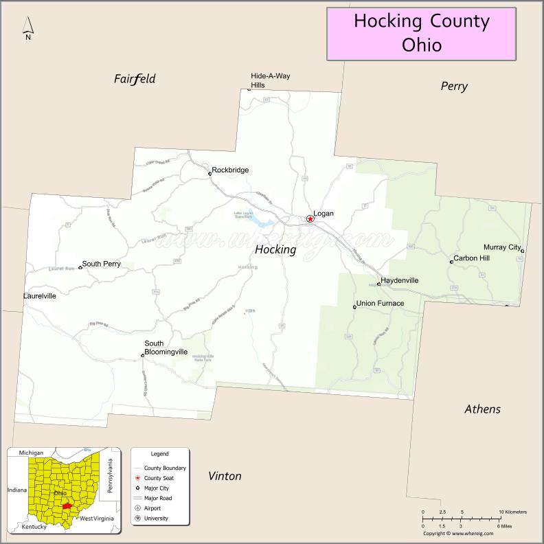
About Hocking County Map, Ohio: The map showing the county boundary, county seat, major cities, highways, water bodies and neighbouring counties.
Ohio More Maps & Info
About Hocking County, Ohio
Hocking County is a county located in the U.S. state of Ohio. It's county seat is Logan. As per 2020 census, the population of Hocking County is 28097 people and population density is square miles. According to the United States Census Bureau, the county has a total area of 422.75 sq mi (1,095 km2). Hocking County was established on -29889.
Hocking County Facts
| Continent | North America |
| Country | United States |
| State | Ohio |
| County Seat | Logan |
| Largest City/Town | Logan |
| Established | March 1, 1818 |
| Total Area | 424 sq mi (1,098 sq km) |
| Land Area | 421 sq mi (1,090 sq km) |
| Water Area | 2.5 sq mi (6.5 sq km) |
| Population | 28,050 (Census 2020) |
| Population Density | 67 people per sq mi |
| Time Zone | Eastern Time Zone (ET) |
| Major Highways | US-33, State Route 56, State Route 93, State Route 664 |
| Neighboring Counties | Athens County, Perry County, Fairfield County, Ross County, Vinton County |
| Famous For | Hocking Hills State Park, caves, waterfalls, outdoor tourism |
| Top Attractions | Hocking Hills State Park, Old Man’s Cave, Ash Cave, Cedar Falls |
| Official Website | https://hockingcountyohio.gov/ |
Cities and Towns in Hocking County, Ohio
- Logan (county seat) – 7,062 (Census 2020)
- Laurelville – 507 (Census 2020)
- Murray City (partly) – 399 (Census 2020)
- Carbon Hill (partly) – 173 (Census 2020)
Roads and Highways in Hocking County, Ohio
Hocking County is connected by scenic highways that provide access to its natural attractions and surrounding regions.
- US-33 – major route connecting Logan to Columbus and Athens
- State Route 56 – east-west highway linking Hocking Hills to Athens and Circleville
- State Route 93 – runs north-south connecting Logan to Lancaster and McArthur
- State Route 664 – provides direct access to Hocking Hills State Park areas
Neighboring Counties of Hocking County
- Fairfield County (north)
- Perry County (northeast)
- Athens County (southeast)
- Vinton County (southwest)
- Ross County (west)
Top Attractions in Hocking County, Ohio
Hocking County is one of Ohio’s top outdoor destinations, known for its natural beauty and scenic landscapes.
- Hocking Hills State Park – popular park with caves, cliffs, and hiking trails
- Old Man’s Cave – one of the most visited natural areas in Ohio
- Ash Cave – large recessed cave with a waterfall
- Cedar Falls – scenic waterfall surrounded by forest
- Rock House – unique cave with tunnel-like openings
- Conkle’s Hollow State Nature Preserve – deep gorge with hiking trails
- Lake Logan State Park – offers boating, fishing, and camping
- Hocking Hills Canopy Tours – zipline experience through forest landscapes
Distance from Hocking County to Nearby Cities
- Hocking County to Columbus – 50 mi (80 km)
- Hocking County to Athens – 30 mi (48 km)
- Hocking County to Chillicothe – 35 mi (56 km)
- Hocking County to Lancaster – 25 mi (40 km)
- Hocking County to Cincinnati – 110 mi (177 km)
FAQs about Hocking County
Hocking County is located in southeastern Ohio.
It is known for Hocking Hills State Park, caves, waterfalls, and outdoor recreation.
The population was 28,050 according to the 2020 Census.
The county seat is Logan.
Yes, the county is known for parks, caves, trails, and scenic natural areas.
- Adams County Map
- Allen County Map
- Ashland County Map
- Ashtabula County Map
- Athens County Map
- Auglaize County Map
- Belmont County Map
- Brown County Map
- Butler County Map
- Carroll County Map
- Champaign County Map
- Clark County Map
- Clermont County Map
- Clinton County Map
- Columbiana County Map
- Coshocton County Map
- Crawford County Map
- Cuyahoga County Map
- Darke County Map
- Defiance County Map
- Delaware County Map
- Erie County Map
- Fairfield County Map
- Fayette County Map
- Franklin County Map
- Fulton County Map
- Gallia County Map
- Geauga County Map
- Greene County Map
- Guernsey County Map
- Hamilton County Map
- Hancock County Map
- Hardin County Map
- Harrison County Map
- Henry County Map
- Highland County Map
- Hocking County Map
- Holmes County Map
- Huron County Map
- Jackson County Map
- Jefferson County Map
- Knox County Map
- Lake County Map
- Lawrence County Map
- Licking County Map
- Logan County Map
- Lorain County Map
- Lucas County Map
- Madison County Map
- Mahoning County Map
- Marion County Map
- Medina County Map
- Meigs County Map
- Mercer County Map
- Miami County Map
- Monroe County Map
- Montgomery County Map
- Morgan County Map
- Morrow County Map
- Muskingum County Map
- Noble County Map
- Ottawa County Map
- Paulding County Map
- Perry County Map
- Pickaway County Map
- Pike County Map
- Portage County Map
- Preble County Map
- Putnam County Map
- Richland County Map
- Ross County Map
- Sandusky County Map
- Scioto County Map
- Seneca County Map
- Shelby County Map
- Stark County Map
- Summit County Map
- Trumbull County Map
- Tuscarawas County Map
- Union County Map
- Van Wert County Map
- Vinton County Map
- Warren County Map
- Washington County Map
- Wayne County Map
- Williams County Map
- Wood County Map
- Wyandot County Map
- Alabama Counties
- Alaska boroughs
- Arizona Counties
- Arkansas Counties
- California County Map
- Colorado Counties
- Connecticut Counties
- Delaware Counties
- Florida County Map
- Georgia County Map
- Hawaii Counties
- Idaho Counties
- Illinois Counties
- Indiana Counties
- Iowa Counties
- Kansas Counties
- Kentucky Counties
- Louisiana Counties
- Maine Counties
- Maryland Counties
- Massachusetts Counties
- Michigan County Map
- Minnesota Counties
- Mississippi Counties
- Missouri Counties
- Montana Counties
- Nebraska Counties
- Nevada Counties
- New York Counties
- New Hampshire Counties
- New Jersey Counties
- New Mexico Counties
- North Carolina Counties
- North Dakota Counties
- Ohio County Map
- Oklahoma Counties
- Oregon Counties
- Pennsylvania Counties
- Rhode Island Counties
- South Carolina Counties
- South Dakota Counties
- Map of Tennessee
- Texas County Map
- Utah Counties
- Vermont Counties
- Virginia Counties
- Washington Counties
- West Virginia Counties
- Wisconsin Counties
- Wyoming Counties