Map of Trumbull County - Trumbull County is a county located in the U.S. state of Ohio. Trumbull County Map showing cities, highways, important places and water bodies. Get Where is Trumbull County located in the map, major cities in Trumbull county, population, areas, and places of interest.
Map of Trumbull County, Ohio
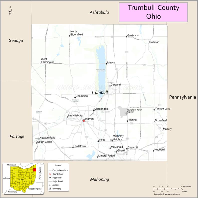
About Trumbull County Map, Ohio: The map showing the county boundary, county seat, major cities, highways, water bodies and neighbouring counties.
Ohio More Maps & Info
About Trumbull County, Ohio
Trumbull County is a county located in the U.S. state of Ohio. It's county seat is Warren. As per 2020 census, the population of Trumbull County is 201335 people and population density is square miles. According to the United States Census Bureau, the county has a total area of 616.48 sq mi (1,597 km2). Trumbull County was established on -36332.
Trumbull County Facts
| Continent | North America |
| Country | United States |
| State | Ohio |
| County Seat | Warren |
| Largest City/Town | Warren |
| Established | July 10, 1800 |
| Total Area | 637 sq mi (1,650 sq km) |
| Land Area | 625 sq mi (1,619 sq km) |
| Water Area | 12 sq mi (31 sq km) |
| Population | 201,977 (Census 2020) |
| Population Density | 323 people per sq mi |
| Time Zone | Eastern Time Zone (ET) |
| Major Highways | I-80 (Ohio Turnpike), I-76, State Route 11, US-422, State Route 5 |
| Neighboring Counties | Ashtabula County, Geauga County, Portage County, Mahoning County, Mercer County (PA) |
| Famous For | Manufacturing history, Mosquito Lake, industrial heritage |
| Top Attractions | Mosquito Lake State Park, National Packard Museum, Trumbull Art Gallery, Eastwood Mall Complex |
| Official Website | https://www.co.trumbull.oh.us/ |
Cities and Towns in Trumbull County, Ohio
- Warren (county seat) – 39,201 (Census 2020)
- Niles – 18,443 (Census 2020)
- Girard – 9,137 (Census 2020)
- Hubbard – 7,558 (Census 2020)
Roads and Highways in Trumbull County, Ohio
Trumbull County is well connected by highways that provide access to northeastern Ohio and western Pennsylvania.
- I-80 (Ohio Turnpike) – major east-west toll road across northern Ohio
- I-76 – connects the county to Akron and Pennsylvania
- State Route 11 – north-south highway linking the county to Youngstown and Ashtabula
- US-422 – runs east-west through Warren and connects to Cleveland and Pennsylvania
- State Route 5 – connects Warren to Youngstown and surrounding areas
Neighboring Counties of Trumbull County
- Ashtabula County (north)
- Geauga County (west)
- Portage County (southwest)
- Mahoning County (south)
- Mercer County, Pennsylvania (east)
Top Attractions in Trumbull County, Ohio
Trumbull County offers a mix of outdoor recreation, history, and cultural attractions.
- Mosquito Lake State Park – popular for boating, fishing, and camping
- National Packard Museum – showcases classic automobiles and history
- Trumbull Art Gallery – features local and regional artwork
- Eastwood Mall Complex – major shopping and entertainment destination
- Warren Historic District – downtown area with historic architecture
- Packard Park – scenic park with walking trails and green space
- Hubbard parks – community parks with recreational facilities
- Girard community area – small-town charm with local events
Distance from Trumbull County to Nearby Cities
- Trumbull County to Youngstown – 15 mi (24 km)
- Trumbull County to Cleveland – 55 mi (89 km)
- Trumbull County to Akron – 50 mi (80 km)
- Trumbull County to Pittsburgh – 70 mi (113 km)
- Trumbull County to Columbus – 160 mi (257 km)
FAQs about Trumbull County
Trumbull County is located in northeastern Ohio.
It is known for its manufacturing history, Mosquito Lake, and industrial heritage.
The population was 201,977 according to the 2020 Census.
The county seat is Warren.
Yes, the county offers parks, museums, and shopping destinations.
- Adams County Map
- Allen County Map
- Ashland County Map
- Ashtabula County Map
- Athens County Map
- Auglaize County Map
- Belmont County Map
- Brown County Map
- Butler County Map
- Carroll County Map
- Champaign County Map
- Clark County Map
- Clermont County Map
- Clinton County Map
- Columbiana County Map
- Coshocton County Map
- Crawford County Map
- Cuyahoga County Map
- Darke County Map
- Defiance County Map
- Delaware County Map
- Erie County Map
- Fairfield County Map
- Fayette County Map
- Franklin County Map
- Fulton County Map
- Gallia County Map
- Geauga County Map
- Greene County Map
- Guernsey County Map
- Hamilton County Map
- Hancock County Map
- Hardin County Map
- Harrison County Map
- Henry County Map
- Highland County Map
- Hocking County Map
- Holmes County Map
- Huron County Map
- Jackson County Map
- Jefferson County Map
- Knox County Map
- Lake County Map
- Lawrence County Map
- Licking County Map
- Logan County Map
- Lorain County Map
- Lucas County Map
- Madison County Map
- Mahoning County Map
- Marion County Map
- Medina County Map
- Meigs County Map
- Mercer County Map
- Miami County Map
- Monroe County Map
- Montgomery County Map
- Morgan County Map
- Morrow County Map
- Muskingum County Map
- Noble County Map
- Ottawa County Map
- Paulding County Map
- Perry County Map
- Pickaway County Map
- Pike County Map
- Portage County Map
- Preble County Map
- Putnam County Map
- Richland County Map
- Ross County Map
- Sandusky County Map
- Scioto County Map
- Seneca County Map
- Shelby County Map
- Stark County Map
- Summit County Map
- Trumbull County Map
- Tuscarawas County Map
- Union County Map
- Van Wert County Map
- Vinton County Map
- Warren County Map
- Washington County Map
- Wayne County Map
- Williams County Map
- Wood County Map
- Wyandot County Map
- Alabama Counties
- Alaska boroughs
- Arizona Counties
- Arkansas Counties
- California County Map
- Colorado Counties
- Connecticut Counties
- Delaware Counties
- Florida County Map
- Georgia County Map
- Hawaii Counties
- Idaho Counties
- Illinois Counties
- Indiana Counties
- Iowa Counties
- Kansas Counties
- Kentucky Counties
- Louisiana Counties
- Maine Counties
- Maryland Counties
- Massachusetts Counties
- Michigan County Map
- Minnesota Counties
- Mississippi Counties
- Missouri Counties
- Montana Counties
- Nebraska Counties
- Nevada Counties
- New York Counties
- New Hampshire Counties
- New Jersey Counties
- New Mexico Counties
- North Carolina Counties
- North Dakota Counties
- Ohio County Map
- Oklahoma Counties
- Oregon Counties
- Pennsylvania Counties
- Rhode Island Counties
- South Carolina Counties
- South Dakota Counties
- Map of Tennessee
- Texas County Map
- Utah Counties
- Vermont Counties
- Virginia Counties
- Washington Counties
- West Virginia Counties
- Wisconsin Counties
- Wyoming Counties