Map of Hamilton County - Hamilton County is a county located in the U.S. state of Ohio. Hamilton County Map showing cities, highways, important places and water bodies. Get Where is Hamilton County located in the map, major cities in Hamilton county, population, areas, and places of interest.
Map of Hamilton County, Ohio
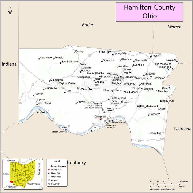
About Hamilton County Map, Ohio: The map showing the county boundary, county seat, major cities, highways, water bodies and neighbouring counties.
Ohio More Maps & Info
About Hamilton County, Ohio
Hamilton County is a county located in the U.S. state of Ohio. It's county seat is Cincinnati. As per 2020 census, the population of Hamilton County is 826139 people and population density is square miles. According to the United States Census Bureau, the county has a total area of 407.36 sq mi (1,055 km2). Hamilton County was established on -40173.
Hamilton County Facts
| Continent | North America |
| Country | United States |
| State | Ohio |
| County Seat | Cincinnati |
| Largest City/Town | Cincinnati |
| Established | January 2, 1790 |
| Total Area | 413 sq mi (1,070 sq km) |
| Land Area | 406 sq mi (1,051 sq km) |
| Water Area | 6.7 sq mi (17.4 sq km) |
| Population | 830,639 (Census 2020) |
| Population Density | 2,046 people per sq mi |
| Time Zone | Eastern Time Zone (ET) |
| Major Highways | I-71, I-74, I-75, I-275, US-27, US-50, US-52 |
| Neighboring Counties | Butler County, Warren County, Clermont County, Boone County (KY), Kenton County (KY), Dearborn County (IN) |
| Famous For | Cincinnati, Ohio River, cultural attractions, sports teams |
| Top Attractions | Cincinnati Zoo, Kings Island (nearby), Fountain Square, Cincinnati Museum Center |
| Official Website | https://www.hamiltoncountyohio.gov/ |
Cities and Towns in Hamilton County, Ohio
- Cincinnati (county seat) – 309,317 (Census 2020)
- Norwood – 19,043 (Census 2020)
- Forest Park – 20,189 (Census 2020)
- Blue Ash – 12,513 (Census 2020)
Roads and Highways in Hamilton County, Ohio
Hamilton County has a major highway network centered around Cincinnati, providing strong regional and interstate connections.
- I-71 – connects Cincinnati to Columbus and Cleveland
- I-74 – runs northwest connecting Cincinnati to Indianapolis
- I-75 – major north-south interstate linking Detroit to Florida through Cincinnati
- I-275 – beltway surrounding the Cincinnati metropolitan area
- US-27 – runs north-south through Cincinnati into Kentucky
- US-50 – east-west route connecting Cincinnati to southeastern Ohio
- US-52 – follows the Ohio River connecting towns along the river corridor
Neighboring Counties of Hamilton County
- Butler County (north)
- Warren County (northeast)
- Clermont County (east)
- Boone County, Kentucky (southwest)
- Kenton County, Kentucky (south)
- Dearborn County, Indiana (west)
Top Attractions in Hamilton County, Ohio
Hamilton County is a major cultural and entertainment hub with attractions along the Ohio River and throughout Cincinnati.
- Cincinnati Zoo and Botanical Garden – one of the oldest zoos in the United States
- Fountain Square – central gathering place in downtown Cincinnati
- Cincinnati Museum Center – large museum complex in a historic train station
- Great American Ball Park – home of the Cincinnati Reds
- Smale Riverfront Park – scenic park along the Ohio River
- Cincinnati Art Museum – features a large collection of artworks
- Eden Park – offers views, gardens, and walking paths
- Findlay Market – historic public market with local vendors and food
Distance from Hamilton County to Nearby Cities
- Hamilton County to Columbus – 105 mi (169 km)
- Hamilton County to Dayton – 50 mi (80 km)
- Hamilton County to Louisville – 100 mi (161 km)
- Hamilton County to Indianapolis – 110 mi (177 km)
- Hamilton County to Lexington – 85 mi (137 km)
FAQs about Hamilton County
Hamilton County is located in southwestern Ohio along the Ohio River.
It is known for Cincinnati, its riverfront, cultural attractions, and professional sports teams.
The population was 830,639 according to the 2020 Census.
Cincinnati is the largest city and also the county seat.
Yes, the county has major attractions including the Cincinnati Zoo, museums, and riverfront parks.
- Adams County Map
- Allen County Map
- Ashland County Map
- Ashtabula County Map
- Athens County Map
- Auglaize County Map
- Belmont County Map
- Brown County Map
- Butler County Map
- Carroll County Map
- Champaign County Map
- Clark County Map
- Clermont County Map
- Clinton County Map
- Columbiana County Map
- Coshocton County Map
- Crawford County Map
- Cuyahoga County Map
- Darke County Map
- Defiance County Map
- Delaware County Map
- Erie County Map
- Fairfield County Map
- Fayette County Map
- Franklin County Map
- Fulton County Map
- Gallia County Map
- Geauga County Map
- Greene County Map
- Guernsey County Map
- Hamilton County Map
- Hancock County Map
- Hardin County Map
- Harrison County Map
- Henry County Map
- Highland County Map
- Hocking County Map
- Holmes County Map
- Huron County Map
- Jackson County Map
- Jefferson County Map
- Knox County Map
- Lake County Map
- Lawrence County Map
- Licking County Map
- Logan County Map
- Lorain County Map
- Lucas County Map
- Madison County Map
- Mahoning County Map
- Marion County Map
- Medina County Map
- Meigs County Map
- Mercer County Map
- Miami County Map
- Monroe County Map
- Montgomery County Map
- Morgan County Map
- Morrow County Map
- Muskingum County Map
- Noble County Map
- Ottawa County Map
- Paulding County Map
- Perry County Map
- Pickaway County Map
- Pike County Map
- Portage County Map
- Preble County Map
- Putnam County Map
- Richland County Map
- Ross County Map
- Sandusky County Map
- Scioto County Map
- Seneca County Map
- Shelby County Map
- Stark County Map
- Summit County Map
- Trumbull County Map
- Tuscarawas County Map
- Union County Map
- Van Wert County Map
- Vinton County Map
- Warren County Map
- Washington County Map
- Wayne County Map
- Williams County Map
- Wood County Map
- Wyandot County Map
- Alabama Counties
- Alaska boroughs
- Arizona Counties
- Arkansas Counties
- California County Map
- Colorado Counties
- Connecticut Counties
- Delaware Counties
- Florida County Map
- Georgia County Map
- Hawaii Counties
- Idaho Counties
- Illinois Counties
- Indiana Counties
- Iowa Counties
- Kansas Counties
- Kentucky Counties
- Louisiana Counties
- Maine Counties
- Maryland Counties
- Massachusetts Counties
- Michigan County Map
- Minnesota Counties
- Mississippi Counties
- Missouri Counties
- Montana Counties
- Nebraska Counties
- Nevada Counties
- New York Counties
- New Hampshire Counties
- New Jersey Counties
- New Mexico Counties
- North Carolina Counties
- North Dakota Counties
- Ohio County Map
- Oklahoma Counties
- Oregon Counties
- Pennsylvania Counties
- Rhode Island Counties
- South Carolina Counties
- South Dakota Counties
- Map of Tennessee
- Texas County Map
- Utah Counties
- Vermont Counties
- Virginia Counties
- Washington Counties
- West Virginia Counties
- Wisconsin Counties
- Wyoming Counties