Map of Wayne County - Wayne County is a county located in the U.S. state of Ohio. Wayne County Map showing cities, highways, important places and water bodies. Get Where is Wayne County located in the map, major cities in Wayne county, population, areas, and places of interest.
Map of Wayne County, Ohio
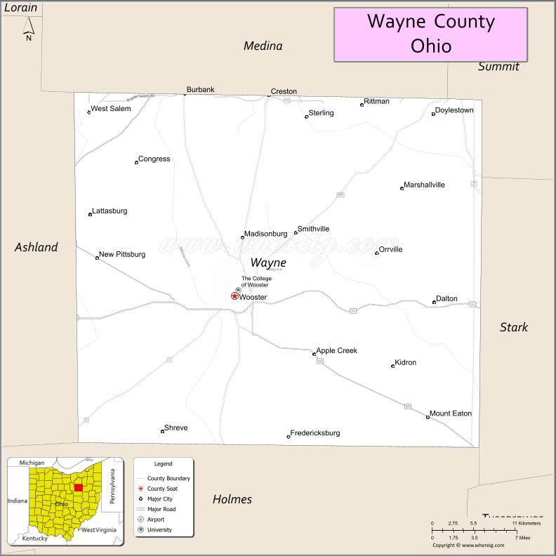
About Wayne County Map, Ohio: The map showing the county boundary, county seat, major cities, highways, water bodies and neighbouring counties.
Ohio More Maps & Info
About Wayne County, Ohio
Wayne County is a county located in the U.S. state of Ohio. It's county seat is Wooster. As per 2020 census, the population of Wayne County is 116710 people and population density is square miles. According to the United States Census Bureau, the county has a total area of 555.36 sq mi (1,438 km2). Wayne County was established on -33541.
Wayne County Facts
| Continent | North America |
| Country | United States |
| State | Ohio |
| County Seat | Wooster |
| Largest City/Town | Wooster |
| Established | January 4, 1812 |
| Total Area | 555 sq mi (1,437 sq km) |
| Land Area | 553 sq mi (1,432 sq km) |
| Water Area | 1.8 sq mi (4.7 sq km) |
| Population | 116,894 (Census 2020) |
| Population Density | 211 people per sq mi |
| Time Zone | Eastern Time Zone (ET) |
| Major Highways | US-30, US-250, State Route 3, State Route 83, State Route 57 |
| Neighboring Counties | Medina County, Summit County, Stark County, Holmes County, Ashland County, Richland County |
| Famous For | Amish community, agriculture, Ohio agricultural research |
| Top Attractions | Ohio Agricultural Research & Development Center, Secrest Arboretum, Holmes-Wayne Amish Country, Wooster Historic District |
| Official Website | https://www.waynecountyohio.org/ |
Cities and Towns in Wayne County, Ohio
- Wooster (county seat) – 26,540 (Census 2020)
- Orrville – 8,380 (Census 2020)
- Rittman – 6,131 (Census 2020)
- Doylestown – 3,074 (Census 2020)
Roads and Highways in Wayne County, Ohio
Wayne County is connected by major highways that support agriculture, commerce, and travel across north-central Ohio.
- US-30 – major east-west route connecting Wooster to Canton and Mansfield
- US-250 – runs through the county connecting Ashland and Stark County
- State Route 3 – north-south highway linking Cleveland to southern Ohio
- State Route 83 – connects Wooster to Millersburg and Amish Country
- State Route 57 – links the county to Medina and Lorain areas
Neighboring Counties of Wayne County
- Medina County (north)
- Summit County (northeast)
- Stark County (east)
- Holmes County (southeast)
- Ashland County (south)
- Richland County (southwest)
Top Attractions in Wayne County, Ohio
Wayne County offers agricultural research, Amish culture, and outdoor attractions.
- Ohio Agricultural Research & Development Center – leading agricultural research facility
- Secrest Arboretum – botanical garden with diverse plant collections
- Holmes-Wayne Amish Country – scenic rural area with Amish culture and markets
- Wooster Historic District – downtown area with historic architecture
- Fredericksburg Amish community – traditional Amish farms and shops
- OARDC gardens and trails – educational and scenic outdoor space
- Kidron area markets – local produce and Amish goods
- Spangler Candy Company nearby (Bryan region influence area) – regional attraction for sweets history
Distance from Wayne County to Nearby Cities
- Wayne County to Akron – 35 mi (56 km)
- Wayne County to Cleveland – 60 mi (97 km)
- Wayne County to Columbus – 95 mi (153 km)
- Wayne County to Canton – 25 mi (40 km)
- Wayne County to Mansfield – 35 mi (56 km)
FAQs about Wayne County
Wayne County is located in northeastern Ohio.
It is known for Amish country, agriculture, and agricultural research institutions.
The population was 116,894 according to the 2020 Census.
The county seat is Wooster.
Yes, Wayne County offers Amish country experiences, arboretums, and agricultural attractions.
- Adams County Map
- Allen County Map
- Ashland County Map
- Ashtabula County Map
- Athens County Map
- Auglaize County Map
- Belmont County Map
- Brown County Map
- Butler County Map
- Carroll County Map
- Champaign County Map
- Clark County Map
- Clermont County Map
- Clinton County Map
- Columbiana County Map
- Coshocton County Map
- Crawford County Map
- Cuyahoga County Map
- Darke County Map
- Defiance County Map
- Delaware County Map
- Erie County Map
- Fairfield County Map
- Fayette County Map
- Franklin County Map
- Fulton County Map
- Gallia County Map
- Geauga County Map
- Greene County Map
- Guernsey County Map
- Hamilton County Map
- Hancock County Map
- Hardin County Map
- Harrison County Map
- Henry County Map
- Highland County Map
- Hocking County Map
- Holmes County Map
- Huron County Map
- Jackson County Map
- Jefferson County Map
- Knox County Map
- Lake County Map
- Lawrence County Map
- Licking County Map
- Logan County Map
- Lorain County Map
- Lucas County Map
- Madison County Map
- Mahoning County Map
- Marion County Map
- Medina County Map
- Meigs County Map
- Mercer County Map
- Miami County Map
- Monroe County Map
- Montgomery County Map
- Morgan County Map
- Morrow County Map
- Muskingum County Map
- Noble County Map
- Ottawa County Map
- Paulding County Map
- Perry County Map
- Pickaway County Map
- Pike County Map
- Portage County Map
- Preble County Map
- Putnam County Map
- Richland County Map
- Ross County Map
- Sandusky County Map
- Scioto County Map
- Seneca County Map
- Shelby County Map
- Stark County Map
- Summit County Map
- Trumbull County Map
- Tuscarawas County Map
- Union County Map
- Van Wert County Map
- Vinton County Map
- Warren County Map
- Washington County Map
- Wayne County Map
- Williams County Map
- Wood County Map
- Wyandot County Map
- Alabama Counties
- Alaska boroughs
- Arizona Counties
- Arkansas Counties
- California County Map
- Colorado Counties
- Connecticut Counties
- Delaware Counties
- Florida County Map
- Georgia County Map
- Hawaii Counties
- Idaho Counties
- Illinois Counties
- Indiana Counties
- Iowa Counties
- Kansas Counties
- Kentucky Counties
- Louisiana Counties
- Maine Counties
- Maryland Counties
- Massachusetts Counties
- Michigan County Map
- Minnesota Counties
- Mississippi Counties
- Missouri Counties
- Montana Counties
- Nebraska Counties
- Nevada Counties
- New York Counties
- New Hampshire Counties
- New Jersey Counties
- New Mexico Counties
- North Carolina Counties
- North Dakota Counties
- Ohio County Map
- Oklahoma Counties
- Oregon Counties
- Pennsylvania Counties
- Rhode Island Counties
- South Carolina Counties
- South Dakota Counties
- Map of Tennessee
- Texas County Map
- Utah Counties
- Vermont Counties
- Virginia Counties
- Washington Counties
- West Virginia Counties
- Wisconsin Counties
- Wyoming Counties