Map of Miami County - Miami County is a county located in the U.S. state of Ohio. Miami County Map showing cities, highways, important places and water bodies. Get Where is Miami County located in the map, major cities in Miami county, population, areas, and places of interest.
Map of Miami County, Ohio
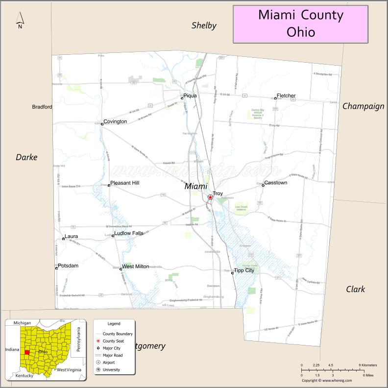
About Miami County Map, Ohio: The map showing the county boundary, county seat, major cities, highways, water bodies and neighbouring counties.
Ohio More Maps & Info
About Miami County, Ohio
Miami County is a county located in the U.S. state of Ohio. It's county seat is Troy. As per 2020 census, the population of Miami County is 109264 people and population density is square miles. According to the United States Census Bureau, the county has a total area of 407.04 sq mi (1,054 km2). Miami County was established on -33907.
Miami County Facts
| Continent | North America |
| Country | United States |
| State | Ohio |
| County Seat | Troy |
| Largest City/Town | Troy |
| Established | March 1, 1807 |
| Total Area | 410 sq mi (1,062 sq km) |
| Land Area | 407 sq mi (1,054 sq km) |
| Water Area | 2.3 sq mi (6.0 sq km) |
| Population | 109,333 (Census 2020) |
| Population Density | 268 people per sq mi |
| Time Zone | Eastern Time Zone (ET) |
| Major Highways | I-75, US-36, State Route 55, State Route 41, State Route 48, State Route 201 |
| Neighboring Counties | Shelby County, Logan County, Champaign County, Clark County, Montgomery County, Darke County |
| Famous For | Aviation history, Troy Strawberry Festival, agriculture |
| Top Attractions | Troy Historic Square, Charleston Falls Preserve, Eldean Covered Bridge, Waco Air Museum |
| Official Website | https://www.miamicountyohio.gov/ |
Cities and Towns in Miami County, Ohio
- Troy (county seat) – 26,305 (Census 2020)
- Piqua – 20,570 (Census 2020)
- Tipp City – 10,274 (Census 2020)
- West Milton – 4,782 (Census 2020)
Roads and Highways in Miami County, Ohio
Miami County is well connected by highways that link it to Dayton and other parts of western Ohio.
- I-75 – major north-south interstate connecting Toledo to Cincinnati through Troy and Piqua
- US-36 – east-west route linking Piqua to Urbana and Greenville
- State Route 55 – connects Troy to Springfield and surrounding areas
- State Route 41 – runs through northern parts of the county linking communities
- State Route 48 – connects Tipp City to Dayton and northwestern Ohio
- State Route 201 – links Piqua to rural areas and neighboring counties
Neighboring Counties of Miami County
- Shelby County (north)
- Logan County (east)
- Champaign County (southeast)
- Clark County (south)
- Montgomery County (southwest)
- Darke County (west)
Top Attractions in Miami County, Ohio
Miami County offers historic sites, outdoor recreation, and community events.
- Troy Historic Square – vibrant downtown area with shops and events
- Charleston Falls Preserve – scenic nature preserve with waterfalls and trails
- Eldean Covered Bridge – historic wooden bridge and local landmark
- Waco Air Museum – aviation museum showcasing early aircraft history
- Piqua Historical Area – features museums and historic buildings
- Great Miami River Recreation Trail – popular for biking and walking
- Johnston Farm & Indian Agency – historic site with educational exhibits
- Troy Strawberry Festival – annual event attracting visitors from across the region
Distance from Miami County to Nearby Cities
- Miami County to Dayton – 20 mi (32 km)
- Miami County to Columbus – 75 mi (121 km)
- Miami County to Cincinnati – 80 mi (129 km)
- Miami County to Toledo – 130 mi (209 km)
- Miami County to Springfield – 25 mi (40 km)
FAQs about Miami County
Miami County is located in western Ohio, north of Dayton.
It is known for aviation history, the Troy Strawberry Festival, and agriculture.
The population was 109,333 according to the 2020 Census.
The county seat is Troy.
Yes, the county offers historic sites, parks, trails, and annual events.
- Adams County Map
- Allen County Map
- Ashland County Map
- Ashtabula County Map
- Athens County Map
- Auglaize County Map
- Belmont County Map
- Brown County Map
- Butler County Map
- Carroll County Map
- Champaign County Map
- Clark County Map
- Clermont County Map
- Clinton County Map
- Columbiana County Map
- Coshocton County Map
- Crawford County Map
- Cuyahoga County Map
- Darke County Map
- Defiance County Map
- Delaware County Map
- Erie County Map
- Fairfield County Map
- Fayette County Map
- Franklin County Map
- Fulton County Map
- Gallia County Map
- Geauga County Map
- Greene County Map
- Guernsey County Map
- Hamilton County Map
- Hancock County Map
- Hardin County Map
- Harrison County Map
- Henry County Map
- Highland County Map
- Hocking County Map
- Holmes County Map
- Huron County Map
- Jackson County Map
- Jefferson County Map
- Knox County Map
- Lake County Map
- Lawrence County Map
- Licking County Map
- Logan County Map
- Lorain County Map
- Lucas County Map
- Madison County Map
- Mahoning County Map
- Marion County Map
- Medina County Map
- Meigs County Map
- Mercer County Map
- Miami County Map
- Monroe County Map
- Montgomery County Map
- Morgan County Map
- Morrow County Map
- Muskingum County Map
- Noble County Map
- Ottawa County Map
- Paulding County Map
- Perry County Map
- Pickaway County Map
- Pike County Map
- Portage County Map
- Preble County Map
- Putnam County Map
- Richland County Map
- Ross County Map
- Sandusky County Map
- Scioto County Map
- Seneca County Map
- Shelby County Map
- Stark County Map
- Summit County Map
- Trumbull County Map
- Tuscarawas County Map
- Union County Map
- Van Wert County Map
- Vinton County Map
- Warren County Map
- Washington County Map
- Wayne County Map
- Williams County Map
- Wood County Map
- Wyandot County Map
- Alabama Counties
- Alaska boroughs
- Arizona Counties
- Arkansas Counties
- California County Map
- Colorado Counties
- Connecticut Counties
- Delaware Counties
- Florida County Map
- Georgia County Map
- Hawaii Counties
- Idaho Counties
- Illinois Counties
- Indiana Counties
- Iowa Counties
- Kansas Counties
- Kentucky Counties
- Louisiana Counties
- Maine Counties
- Maryland Counties
- Massachusetts Counties
- Michigan County Map
- Minnesota Counties
- Mississippi Counties
- Missouri Counties
- Montana Counties
- Nebraska Counties
- Nevada Counties
- New York Counties
- New Hampshire Counties
- New Jersey Counties
- New Mexico Counties
- North Carolina Counties
- North Dakota Counties
- Ohio County Map
- Oklahoma Counties
- Oregon Counties
- Pennsylvania Counties
- Rhode Island Counties
- South Carolina Counties
- South Dakota Counties
- Map of Tennessee
- Texas County Map
- Utah Counties
- Vermont Counties
- Virginia Counties
- Washington Counties
- West Virginia Counties
- Wisconsin Counties
- Wyoming Counties