Map of Union County - Union County is a county located in the U.S. state of Ohio. Union County Map showing cities, highways, important places and water bodies. Get Where is Union County located in the map, major cities in Union county, population, areas, and places of interest.
Map of Union County, Ohio
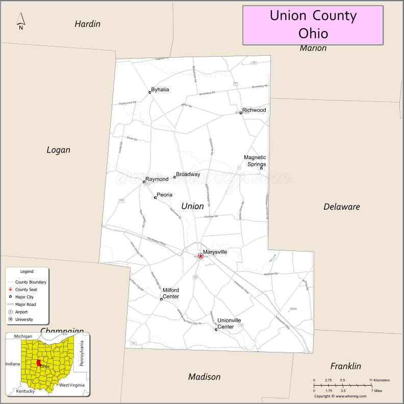
About Union County Map, Ohio: The map showing the county boundary, county seat, major cities, highways, water bodies and neighbouring counties.
Ohio More Maps & Info
About Union County, Ohio
Union County is a county located in the U.S. state of Ohio. It's county seat is Marysville. As per 2020 census, the population of Union County is 64971 people and population density is square miles. According to the United States Census Bureau, the county has a total area of 436.65 sq mi (1,131 km2). Union County was established on -29127.
Union County Facts
| Continent | North America |
| Country | United States |
| State | Ohio |
| County Seat | Marysville |
| Largest City/Town | Marysville |
| Established | April 1, 1820 |
| Total Area | 432 sq mi (1,118 sq km) |
| Land Area | 431 sq mi (1,116 sq km) |
| Water Area | 1.4 sq mi (3.6 sq km) |
| Population | 62,784 (Census 2020) |
| Population Density | 146 people per sq mi |
| Time Zone | Eastern Time Zone (ET) |
| Major Highways | US-33, US-36, State Route 4, State Route 31, State Route 38 |
| Neighboring Counties | Delaware County, Franklin County, Madison County, Champaign County, Logan County, Hardin County |
| Famous For | Agriculture, Honda manufacturing, rapid growth |
| Top Attractions | Union County Historical Society, Glacier Ridge Metro Park nearby, Marysville Historic District, Honda Heritage Center |
| Official Website | https://www.co.union.oh.us/ |
Cities and Towns in Union County, Ohio
- Marysville (county seat) – 25,571 (Census 2020)
- Dublin (partly) – 49,328 (Census 2020, shared)
- Richwood – 2,229 (Census 2020)
- Milford Center – 827 (Census 2020)
Roads and Highways in Union County, Ohio
Union County is well connected by highways that link it to Columbus and surrounding regions.
- US-33 – major highway connecting Marysville to Columbus and Lima
- US-36 – east-west route linking the county to Delaware and Urbana
- State Route 4 – connects Marysville to Springfield and Bucyrus
- State Route 31 – runs north-south through the county
- State Route 38 – connects Marysville to London and Kenton
Neighboring Counties of Union County
- Delaware County (east)
- Franklin County (southeast)
- Madison County (south)
- Champaign County (west)
- Logan County (northwest)
- Hardin County (north)
Top Attractions in Union County, Ohio
Union County offers parks, history, and industrial tourism.
- Honda Heritage Center – museum showcasing Honda’s history in Ohio
- Marysville Historic District – downtown area with shops and historic buildings
- Union County Historical Society – local history museum
- Glacier Ridge Metro Park nearby – trails, fishing, and outdoor recreation
- Piatt Castles nearby – historic castle-style homes
- Mill Creek area – scenic outdoor space
- Memorial Park in Marysville – community park with events
- Local farmland tours – agricultural landscapes and rural scenery
Distance from Union County to Nearby Cities
- Union County to Columbus – 30 mi (48 km)
- Union County to Dayton – 65 mi (105 km)
- Union County to Springfield – 30 mi (48 km)
- Union County to Lima – 70 mi (113 km)
- Union County to Cincinnati – 120 mi (193 km)
FAQs about Union County
Union County is located in central Ohio, northwest of Columbus.
It is known for agriculture, Honda manufacturing, and rapid residential growth.
The population was 62,784 according to the 2020 Census.
The county seat is Marysville.
Yes, the county offers museums, parks, historic districts, and industrial heritage sites.
- Adams County Map
- Allen County Map
- Ashland County Map
- Ashtabula County Map
- Athens County Map
- Auglaize County Map
- Belmont County Map
- Brown County Map
- Butler County Map
- Carroll County Map
- Champaign County Map
- Clark County Map
- Clermont County Map
- Clinton County Map
- Columbiana County Map
- Coshocton County Map
- Crawford County Map
- Cuyahoga County Map
- Darke County Map
- Defiance County Map
- Delaware County Map
- Erie County Map
- Fairfield County Map
- Fayette County Map
- Franklin County Map
- Fulton County Map
- Gallia County Map
- Geauga County Map
- Greene County Map
- Guernsey County Map
- Hamilton County Map
- Hancock County Map
- Hardin County Map
- Harrison County Map
- Henry County Map
- Highland County Map
- Hocking County Map
- Holmes County Map
- Huron County Map
- Jackson County Map
- Jefferson County Map
- Knox County Map
- Lake County Map
- Lawrence County Map
- Licking County Map
- Logan County Map
- Lorain County Map
- Lucas County Map
- Madison County Map
- Mahoning County Map
- Marion County Map
- Medina County Map
- Meigs County Map
- Mercer County Map
- Miami County Map
- Monroe County Map
- Montgomery County Map
- Morgan County Map
- Morrow County Map
- Muskingum County Map
- Noble County Map
- Ottawa County Map
- Paulding County Map
- Perry County Map
- Pickaway County Map
- Pike County Map
- Portage County Map
- Preble County Map
- Putnam County Map
- Richland County Map
- Ross County Map
- Sandusky County Map
- Scioto County Map
- Seneca County Map
- Shelby County Map
- Stark County Map
- Summit County Map
- Trumbull County Map
- Tuscarawas County Map
- Union County Map
- Van Wert County Map
- Vinton County Map
- Warren County Map
- Washington County Map
- Wayne County Map
- Williams County Map
- Wood County Map
- Wyandot County Map
- Alabama Counties
- Alaska boroughs
- Arizona Counties
- Arkansas Counties
- California County Map
- Colorado Counties
- Connecticut Counties
- Delaware Counties
- Florida County Map
- Georgia County Map
- Hawaii Counties
- Idaho Counties
- Illinois Counties
- Indiana Counties
- Iowa Counties
- Kansas Counties
- Kentucky Counties
- Louisiana Counties
- Maine Counties
- Maryland Counties
- Massachusetts Counties
- Michigan County Map
- Minnesota Counties
- Mississippi Counties
- Missouri Counties
- Montana Counties
- Nebraska Counties
- Nevada Counties
- New York Counties
- New Hampshire Counties
- New Jersey Counties
- New Mexico Counties
- North Carolina Counties
- North Dakota Counties
- Ohio County Map
- Oklahoma Counties
- Oregon Counties
- Pennsylvania Counties
- Rhode Island Counties
- South Carolina Counties
- South Dakota Counties
- Map of Tennessee
- Texas County Map
- Utah Counties
- Vermont Counties
- Virginia Counties
- Washington Counties
- West Virginia Counties
- Wisconsin Counties
- Wyoming Counties