Map of Montgomery County - Montgomery County is a county located in the U.S. state of Ohio. Montgomery County Map showing cities, highways, important places and water bodies. Get Where is Montgomery County located in the map, major cities in Montgomery county, population, areas, and places of interest.
Map of Montgomery County, Ohio
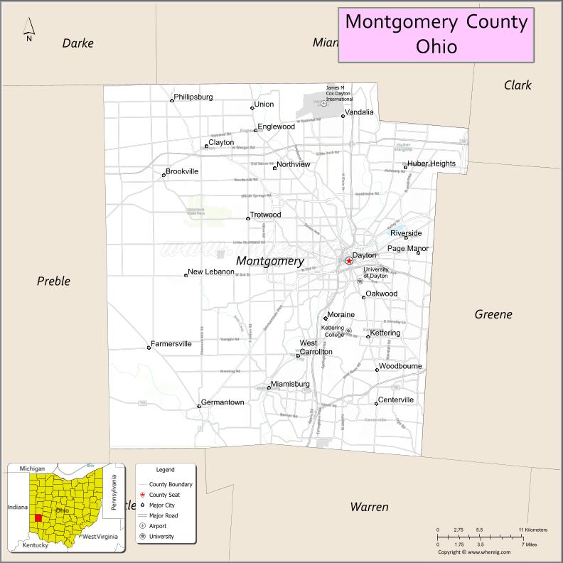
About Montgomery County Map, Ohio: The map showing the county boundary, county seat, major cities, highways, water bodies and neighbouring counties.
Ohio More Maps & Info
About Montgomery County, Ohio
Montgomery County is a county located in the U.S. state of Ohio. It's county seat is Dayton. As per 2020 census, the population of Montgomery County is 535840 people and population density is square miles. According to the United States Census Bureau, the county has a total area of 461.68 sq mi (1,196 km2). Montgomery County was established on -35307.
Montgomery County Facts
| Continent | North America |
| Country | United States |
| State | Ohio |
| County Seat | Dayton |
| Largest City/Town | Dayton |
| Established | May 1, 1803 |
| Total Area | 464 sq mi (1,202 sq km) |
| Land Area | 462 sq mi (1,196 sq km) |
| Water Area | 2.2 sq mi (5.7 sq km) |
| Population | 537,309 (Census 2020) |
| Population Density | 1,163 people per sq mi |
| Time Zone | Eastern Time Zone (ET) |
| Major Highways | I-75, I-70, I-675, US-35, US-40, US-127 |
| Neighboring Counties | Miami County, Greene County, Clark County, Warren County, Preble County, Darke County |
| Famous For | Dayton, aviation history, Wright brothers, manufacturing |
| Top Attractions | National Museum of the U.S. Air Force, Carillon Historical Park, Dayton Aviation Heritage Park, Five Rivers MetroParks |
| Official Website | https://www.mcohio.org/ |
Cities and Towns in Montgomery County, Ohio
- Dayton (county seat) – 137,644 (Census 2020)
- Kettering – 57,862 (Census 2020)
- Huber Heights – 43,439 (Census 2020)
- Miamisburg – 20,181 (Census 2020)
Roads and Highways in Montgomery County, Ohio
Montgomery County is a major transportation hub in western Ohio with extensive highway connections.
- I-75 – major north-south interstate connecting Dayton to Toledo and Cincinnati
- I-70 – major east-west interstate linking Dayton to Columbus and Indianapolis
- I-675 – bypass loop around Dayton connecting suburbs
- US-35 – connects Dayton to Chillicothe and Richmond, Indiana
- US-40 – historic route running east-west through the county
- US-127 – north-south route connecting the county to Michigan and Kentucky
Neighboring Counties of Montgomery County
- Miami County (north)
- Clark County (northeast)
- Greene County (east)
- Warren County (south)
- Preble County (west)
- Darke County (northwest)
Top Attractions in Montgomery County, Ohio
Montgomery County offers major cultural attractions, parks, and historic sites centered around Dayton.
- National Museum of the U.S. Air Force – one of the largest aviation museums in the world
- Carillon Historical Park – showcases Dayton’s history and innovation
- Dayton Aviation Heritage National Historical Park – honors the Wright brothers
- Five Rivers MetroParks – network of parks with trails and outdoor activities
- Boone Street Market – vibrant public market in Dayton
- Oregon District – historic neighborhood with shops, dining, and nightlife
- Dayton Art Institute – museum with diverse art collections
- RiverScape MetroPark – downtown park with riverfront views and events
Distance from Montgomery County to Nearby Cities
- Montgomery County to Cincinnati – 50 mi (80 km)
- Montgomery County to Columbus – 70 mi (113 km)
- Montgomery County to Indianapolis – 110 mi (177 km)
- Montgomery County to Toledo – 150 mi (241 km)
- Montgomery County to Cleveland – 220 mi (354 km)
FAQs about Montgomery County
Montgomery County is located in western Ohio and is centered around the city of Dayton.
It is known for aviation history, the Wright brothers, and its role in manufacturing.
The population was 537,309 according to the 2020 Census.
The county seat is Dayton.
Yes, the county offers museums, parks, and historic sites.
- Adams County Map
- Allen County Map
- Ashland County Map
- Ashtabula County Map
- Athens County Map
- Auglaize County Map
- Belmont County Map
- Brown County Map
- Butler County Map
- Carroll County Map
- Champaign County Map
- Clark County Map
- Clermont County Map
- Clinton County Map
- Columbiana County Map
- Coshocton County Map
- Crawford County Map
- Cuyahoga County Map
- Darke County Map
- Defiance County Map
- Delaware County Map
- Erie County Map
- Fairfield County Map
- Fayette County Map
- Franklin County Map
- Fulton County Map
- Gallia County Map
- Geauga County Map
- Greene County Map
- Guernsey County Map
- Hamilton County Map
- Hancock County Map
- Hardin County Map
- Harrison County Map
- Henry County Map
- Highland County Map
- Hocking County Map
- Holmes County Map
- Huron County Map
- Jackson County Map
- Jefferson County Map
- Knox County Map
- Lake County Map
- Lawrence County Map
- Licking County Map
- Logan County Map
- Lorain County Map
- Lucas County Map
- Madison County Map
- Mahoning County Map
- Marion County Map
- Medina County Map
- Meigs County Map
- Mercer County Map
- Miami County Map
- Monroe County Map
- Montgomery County Map
- Morgan County Map
- Morrow County Map
- Muskingum County Map
- Noble County Map
- Ottawa County Map
- Paulding County Map
- Perry County Map
- Pickaway County Map
- Pike County Map
- Portage County Map
- Preble County Map
- Putnam County Map
- Richland County Map
- Ross County Map
- Sandusky County Map
- Scioto County Map
- Seneca County Map
- Shelby County Map
- Stark County Map
- Summit County Map
- Trumbull County Map
- Tuscarawas County Map
- Union County Map
- Van Wert County Map
- Vinton County Map
- Warren County Map
- Washington County Map
- Wayne County Map
- Williams County Map
- Wood County Map
- Wyandot County Map
- Alabama Counties
- Alaska boroughs
- Arizona Counties
- Arkansas Counties
- California County Map
- Colorado Counties
- Connecticut Counties
- Delaware Counties
- Florida County Map
- Georgia County Map
- Hawaii Counties
- Idaho Counties
- Illinois Counties
- Indiana Counties
- Iowa Counties
- Kansas Counties
- Kentucky Counties
- Louisiana Counties
- Maine Counties
- Maryland Counties
- Massachusetts Counties
- Michigan County Map
- Minnesota Counties
- Mississippi Counties
- Missouri Counties
- Montana Counties
- Nebraska Counties
- Nevada Counties
- New York Counties
- New Hampshire Counties
- New Jersey Counties
- New Mexico Counties
- North Carolina Counties
- North Dakota Counties
- Ohio County Map
- Oklahoma Counties
- Oregon Counties
- Pennsylvania Counties
- Rhode Island Counties
- South Carolina Counties
- South Dakota Counties
- Map of Tennessee
- Texas County Map
- Utah Counties
- Vermont Counties
- Virginia Counties
- Washington Counties
- West Virginia Counties
- Wisconsin Counties
- Wyoming Counties