Map of Adams County - Adams County is a county located in the U.S. state of Ohio. Adams County Map showing cities, highways, important places and water bodies. Get Where is Adams County located in the map, major cities in Adams county, population, areas, and places of interest.
Map of Adams County, Ohio
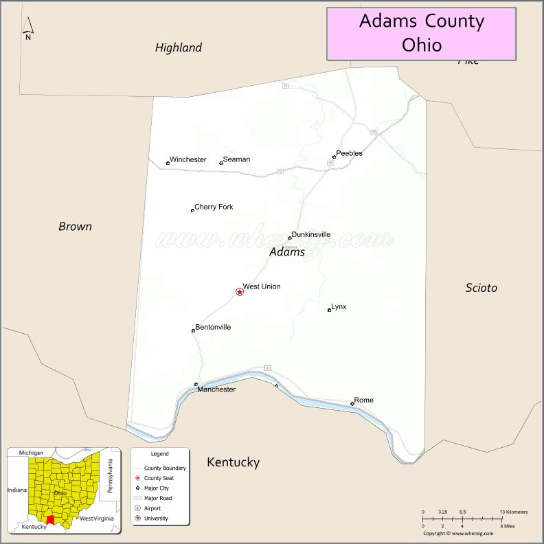
About Adams County Map, Ohio: The map showing the county boundary, county seat, major cities, highways, water bodies and neighbouring counties.
Ohio More Maps & Info
About Adams County, Ohio
Adams County is a county located in the U.S. state of Ohio. It's county seat is West Union. As per 2020 census, the population of Adams County is 27542 people and population density is square miles. According to the United States Census Bureau, the county has a total area of 583.91 sq mi (1,512 km2). Adams County was established on -37427.
Adams County Facts
| Continent | North America |
| Country | United States |
| State | Ohio |
| County Seat | West Union |
| Largest City/Town | West Union |
| Established | 1797 |
| Total Area | 584 sq mi |
| Land Area | 584 sq mi |
| Water Area | 0.5 sq mi |
| Population | 27,477 (Census 2020) |
| Population Density | 47 people per sq mi |
| Time Zone | Eastern (EST) |
| Major Highways | US-52, SR-32, SR-41 |
| Neighboring Counties | Brown County, Highland County, Pike County (OH), Scioto County (OH), Lewis County (KY) |
| Famous For | Ohio River scenery, rural landscapes, Serpent Mound nearby region |
| Top Attractions | Shawnee State Park (nearby), Serpent Mound, Ohio River Scenic Byway |
| Official Website | https://www.adamscountyoh.gov |
Cities and Towns in Adams County, Ohio
- West Union (county seat) – 3,264 (Census 2020)
- Manchester – 2,023 (Census 2020)
- Peebles – 1,773 (Census 2020)
- Seaman – 1,025 (Census 2020)
Roads and Highways in Adams County, Ohio
Adams County is served by several highways that connect southern Ohio communities and provide access to Kentucky and major Ohio cities.
- US Route 52 (US-52) – Runs along the Ohio River connecting Cincinnati and Portsmouth
- State Route 32 (SR-32) – Major east-west route linking the county to Cincinnati and eastern Ohio
- State Route 41 (SR-41) – Connects local towns and neighboring counties
Neighboring Counties of Adams County
- Brown County (north)
- Highland County (northeast)
- Pike County (west)
- Scioto County (northwest)
- Lewis County, Kentucky (south, across Ohio River)
Top Attractions in Adams County, Ohio
Adams County is known for its scenic hills, river views, and unique prehistoric sites.
- Serpent Mound – Famous ancient Native American effigy mound
- Ohio River Scenic Byway – Scenic drive along the river
- Adams Lake State Park – Fishing, boating, and camping destination
- Shawnee State Forest (nearby) – Large forest with hiking trails and wildlife
- West Union Historic District – Local shops and historic architecture
- Rocky Fork State Park (nearby region) – Outdoor recreation area
- Brush Creek area – Popular for kayaking and nature viewing
Distance from Adams County to Nearby Cities
- West Union to Cincinnati – 70 mi (113 km)
- West Union to Columbus – 105 mi (169 km)
- West Union to Portsmouth – 35 mi (56 km)
- West Union to Chillicothe – 60 mi (97 km)
- West Union to Lexington, KY – 120 mi (193 km)
FAQs about Adams County
Adams County is known for the Serpent Mound, scenic Ohio River views, and rural landscapes.
West Union is the county seat of Adams County.
Yes, Adams County is a largely rural area with small towns and farmland.
Visitors enjoy Serpent Mound, river scenery, parks, and outdoor recreation areas.
The Ohio River forms the southern border of Adams County.
- Adams County Map
- Allen County Map
- Ashland County Map
- Ashtabula County Map
- Athens County Map
- Auglaize County Map
- Belmont County Map
- Brown County Map
- Butler County Map
- Carroll County Map
- Champaign County Map
- Clark County Map
- Clermont County Map
- Clinton County Map
- Columbiana County Map
- Coshocton County Map
- Crawford County Map
- Cuyahoga County Map
- Darke County Map
- Defiance County Map
- Delaware County Map
- Erie County Map
- Fairfield County Map
- Fayette County Map
- Franklin County Map
- Fulton County Map
- Gallia County Map
- Geauga County Map
- Greene County Map
- Guernsey County Map
- Hamilton County Map
- Hancock County Map
- Hardin County Map
- Harrison County Map
- Henry County Map
- Highland County Map
- Hocking County Map
- Holmes County Map
- Huron County Map
- Jackson County Map
- Jefferson County Map
- Knox County Map
- Lake County Map
- Lawrence County Map
- Licking County Map
- Logan County Map
- Lorain County Map
- Lucas County Map
- Madison County Map
- Mahoning County Map
- Marion County Map
- Medina County Map
- Meigs County Map
- Mercer County Map
- Miami County Map
- Monroe County Map
- Montgomery County Map
- Morgan County Map
- Morrow County Map
- Muskingum County Map
- Noble County Map
- Ottawa County Map
- Paulding County Map
- Perry County Map
- Pickaway County Map
- Pike County Map
- Portage County Map
- Preble County Map
- Putnam County Map
- Richland County Map
- Ross County Map
- Sandusky County Map
- Scioto County Map
- Seneca County Map
- Shelby County Map
- Stark County Map
- Summit County Map
- Trumbull County Map
- Tuscarawas County Map
- Union County Map
- Van Wert County Map
- Vinton County Map
- Warren County Map
- Washington County Map
- Wayne County Map
- Williams County Map
- Wood County Map
- Wyandot County Map
- Alabama Counties
- Alaska boroughs
- Arizona Counties
- Arkansas Counties
- California County Map
- Colorado Counties
- Connecticut Counties
- Delaware Counties
- Florida County Map
- Georgia County Map
- Hawaii Counties
- Idaho Counties
- Illinois Counties
- Indiana Counties
- Iowa Counties
- Kansas Counties
- Kentucky Counties
- Louisiana Counties
- Maine Counties
- Maryland Counties
- Massachusetts Counties
- Michigan County Map
- Minnesota Counties
- Mississippi Counties
- Missouri Counties
- Montana Counties
- Nebraska Counties
- Nevada Counties
- New York Counties
- New Hampshire Counties
- New Jersey Counties
- New Mexico Counties
- North Carolina Counties
- North Dakota Counties
- Ohio County Map
- Oklahoma Counties
- Oregon Counties
- Pennsylvania Counties
- Rhode Island Counties
- South Carolina Counties
- South Dakota Counties
- Map of Tennessee
- Texas County Map
- Utah Counties
- Vermont Counties
- Virginia Counties
- Washington Counties
- West Virginia Counties
- Wisconsin Counties
- Wyoming Counties