Map of Fairfield County - Fairfield County is a county located in the U.S. state of Ohio. Fairfield County Map showing cities, highways, important places and water bodies. Get Where is Fairfield County located in the map, major cities in Fairfield county, population, areas, and places of interest.
Map of Fairfield County, Ohio
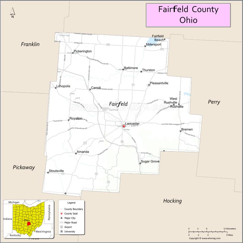
About Fairfield County Map, Ohio: The map showing the county boundary, county seat, major cities, highways, water bodies and neighbouring counties.
Ohio More Maps & Info
About Fairfield County, Ohio
Fairfield County is a county located in the U.S. state of Ohio. It's county seat is Lancaster. As per 2020 census, the population of Fairfield County is 161064 people and population density is square miles. According to the United States Census Bureau, the county has a total area of 505.11 sq mi (1,308 km2). Fairfield County was established on -36180.
Fairfield County Facts
| Continent | North America |
| Country | United States |
| State | Ohio |
| County Seat | Lancaster |
| Largest City/Town | Lancaster |
| Established | December 9, 1800 |
| Total Area | 509 sq mi (1,318 sq km) |
| Land Area | 504 sq mi (1,305 sq km) |
| Water Area | 5.1 sq mi (13.2 sq km) |
| Population | 158,921 (Census 2020) |
| Population Density | 315 people per sq mi |
| Time Zone | Eastern Time Zone (ET) |
| Major Highways | US-22, US-33, State Route 13, State Route 37, State Route 158, State Route 188 |
| Neighboring Counties | Licking County, Perry County, Hocking County, Pickaway County, Franklin County |
| Famous For | Historic Lancaster, covered bridges, outdoor parks, proximity to Columbus |
| Top Attractions | Hocking Hills access, Rising Park, Ohio Glass Museum, Alley Park |
| Official Website | https://www.co.fairfield.oh.us/ |
Cities and Towns in Fairfield County, Ohio
- Lancaster (county seat) – 40,183 (Census 2020)
- Pickerington (partly) – 23,094 (Census 2020)
- Baltimore – 3,051 (Census 2020)
- Canal Winchester (partly) – 9,107 (Census 2020)
Roads and Highways in Fairfield County, Ohio
Fairfield County has several major highways that connect it to Columbus and surrounding parts of central and southeastern Ohio.
- US-22 – east-west route connecting Lancaster to Circleville and Zanesville
- US-33 – major route linking Columbus to southeastern Ohio through the county
- State Route 13 – runs north-south connecting Newark to Athens
- State Route 37 – connects Lancaster to Delaware and other central Ohio areas
- State Route 158 – runs through Lancaster and connects nearby rural communities
- State Route 188 – links Lancaster to Circleville and surrounding towns
Neighboring Counties of Fairfield County
- Licking County (north)
- Perry County (east)
- Hocking County (south)
- Pickaway County (west)
- Franklin County (northwest)
Top Attractions in Fairfield County, Ohio
Fairfield County offers scenic parks, historic sites, and outdoor activities close to Columbus.
- Rising Park – popular park with hiking trails and views of Mount Pleasant
- Alley Park – large park with trails, historic buildings, and nature programs
- Ohio Glass Museum – showcases the region’s glassmaking history
- Rock Mill Park – features a historic mill and scenic gorge
- Hocking Hills region access – nearby natural area with cliffs, caves, and trails
- Fairfield County Covered Bridges – historic bridges scattered across the county
- Smeck Park – quiet park with wetlands, trails, and birdwatching
- Downtown Lancaster – charming area with shops, dining, and events
Distance from Fairfield County to Nearby Cities
- Fairfield County to Columbus – 30 mi (48 km)
- Fairfield County to Newark – 25 mi (40 km)
- Fairfield County to Zanesville – 45 mi (72 km)
- Fairfield County to Chillicothe – 40 mi (64 km)
- Fairfield County to Athens – 75 mi (121 km)
FAQs about Fairfield County
Fairfield County is located in central Ohio, southeast of Columbus.
It is known for its historic sites, covered bridges, and access to outdoor recreation areas.
The population was 158,921 according to the 2020 Census.
Lancaster is the largest city and also the county seat.
Yes, the county has many parks including Rising Park, Alley Park, and Rock Mill Park.
- Adams County Map
- Allen County Map
- Ashland County Map
- Ashtabula County Map
- Athens County Map
- Auglaize County Map
- Belmont County Map
- Brown County Map
- Butler County Map
- Carroll County Map
- Champaign County Map
- Clark County Map
- Clermont County Map
- Clinton County Map
- Columbiana County Map
- Coshocton County Map
- Crawford County Map
- Cuyahoga County Map
- Darke County Map
- Defiance County Map
- Delaware County Map
- Erie County Map
- Fairfield County Map
- Fayette County Map
- Franklin County Map
- Fulton County Map
- Gallia County Map
- Geauga County Map
- Greene County Map
- Guernsey County Map
- Hamilton County Map
- Hancock County Map
- Hardin County Map
- Harrison County Map
- Henry County Map
- Highland County Map
- Hocking County Map
- Holmes County Map
- Huron County Map
- Jackson County Map
- Jefferson County Map
- Knox County Map
- Lake County Map
- Lawrence County Map
- Licking County Map
- Logan County Map
- Lorain County Map
- Lucas County Map
- Madison County Map
- Mahoning County Map
- Marion County Map
- Medina County Map
- Meigs County Map
- Mercer County Map
- Miami County Map
- Monroe County Map
- Montgomery County Map
- Morgan County Map
- Morrow County Map
- Muskingum County Map
- Noble County Map
- Ottawa County Map
- Paulding County Map
- Perry County Map
- Pickaway County Map
- Pike County Map
- Portage County Map
- Preble County Map
- Putnam County Map
- Richland County Map
- Ross County Map
- Sandusky County Map
- Scioto County Map
- Seneca County Map
- Shelby County Map
- Stark County Map
- Summit County Map
- Trumbull County Map
- Tuscarawas County Map
- Union County Map
- Van Wert County Map
- Vinton County Map
- Warren County Map
- Washington County Map
- Wayne County Map
- Williams County Map
- Wood County Map
- Wyandot County Map
- Alabama Counties
- Alaska boroughs
- Arizona Counties
- Arkansas Counties
- California County Map
- Colorado Counties
- Connecticut Counties
- Delaware Counties
- Florida County Map
- Georgia County Map
- Hawaii Counties
- Idaho Counties
- Illinois Counties
- Indiana Counties
- Iowa Counties
- Kansas Counties
- Kentucky Counties
- Louisiana Counties
- Maine Counties
- Maryland Counties
- Massachusetts Counties
- Michigan County Map
- Minnesota Counties
- Mississippi Counties
- Missouri Counties
- Montana Counties
- Nebraska Counties
- Nevada Counties
- New York Counties
- New Hampshire Counties
- New Jersey Counties
- New Mexico Counties
- North Carolina Counties
- North Dakota Counties
- Ohio County Map
- Oklahoma Counties
- Oregon Counties
- Pennsylvania Counties
- Rhode Island Counties
- South Carolina Counties
- South Dakota Counties
- Map of Tennessee
- Texas County Map
- Utah Counties
- Vermont Counties
- Virginia Counties
- Washington Counties
- West Virginia Counties
- Wisconsin Counties
- Wyoming Counties