Map of Williams County - Williams County is a county located in the U.S. state of Ohio. Williams County Map showing cities, highways, important places and water bodies. Get Where is Williams County located in the map, major cities in Williams county, population, areas, and places of interest.
Map of Williams County, Ohio
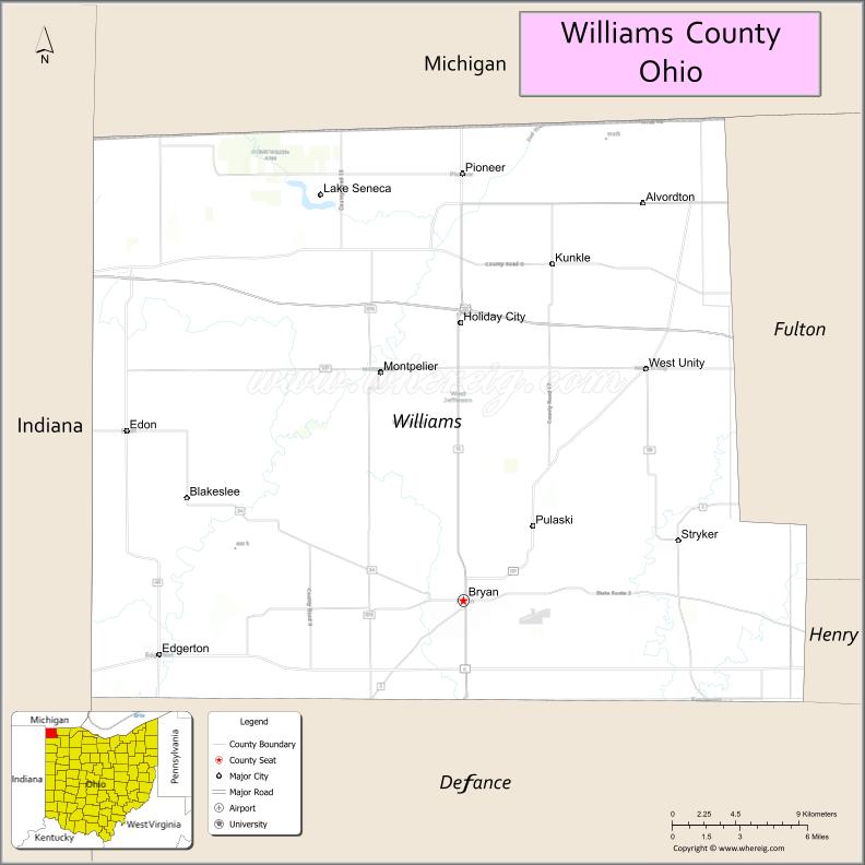
About Williams County Map, Ohio: The map showing the county boundary, county seat, major cities, highways, water bodies and neighbouring counties.
Ohio More Maps & Info
About Williams County, Ohio
Williams County is a county located in the U.S. state of Ohio. It's county seat is Bryan. As per 2020 census, the population of Williams County is 36716 people and population density is square miles. According to the United States Census Bureau, the county has a total area of 421.74 sq mi (1,092 km2). Williams County was established on -29127.
Williams County Facts
| Continent | North America |
| Country | United States |
| State | Ohio |
| County Seat | Bryan |
| Largest City/Town | Bryan |
| Established | April 1, 1824 |
| Total Area | 423 sq mi (1,096 sq km) |
| Land Area | 421 sq mi (1,091 sq km) |
| Water Area | 1.9 sq mi (4.9 sq km) |
| Population | 37,102 (Census 2020) |
| Population Density | 88 people per sq mi |
| Time Zone | Eastern Time Zone (ET) |
| Major Highways | US-20A, US-6, State Route 15, State Route 49, State Route 576 |
| Neighboring Counties | Defiance County, Henry County, Fulton County, Hillsdale County (MI), Lenawee County (MI), Steuben County (IN) |
| Famous For | Rural farming communities, Indiana/Michigan border location, quiet countryside |
| Top Attractions | Lake Seneca, Stoney Ridge Winery, Bryan Historic District, Harrison Lake State Park nearby |
| Official Website | https://www.williamscountyoh.gov/ |
Cities and Towns in Williams County, Ohio
- Bryan (county seat) – 8,729 (Census 2020)
- Montpelier – 4,072 (Census 2020)
- Edgerton – 1,920 (Census 2020)
- Stryker – 1,259 (Census 2020)
Roads and Highways in Williams County, Ohio
Williams County is located in far northwest Ohio and connects to Michigan and Indiana through key highways.
- US-6 – east-west route connecting Bryan to Indiana and Toledo region
- US-20A – alternate east-west highway through the county
- State Route 15 – north-south route connecting Bryan to Defiance and Michigan
- State Route 49 – links the county to Ohio’s western border and Indiana
- State Route 576 – local connector route in rural areas
Neighboring Counties of Williams County
- Fulton County (east)
- Henry County (southeast)
- Defiance County (south)
- Hillsdale County, Michigan (north)
- Lenawee County, Michigan (northeast)
- Steuben County, Indiana (west)
Top Attractions in Williams County, Ohio
Williams County offers rural recreation, small-town history, and outdoor activities.
- Lake Seneca – scenic lake for fishing and outdoor recreation
- Stoney Ridge Winery – local winery with tastings and events
- Bryan Historic District – downtown area with historic architecture and shops
- Harrison Lake State Park nearby – camping, hiking, and boating
- Fulton County Reservoir nearby – additional recreational opportunities
- Montpelier parks – community parks and local recreation
- Edgerton community area – small-town charm and events
- Rural farmland scenery – expansive agricultural landscapes
Distance from Williams County to Nearby Cities
- Williams County to Toledo – 60 mi (97 km)
- Williams County to Fort Wayne – 65 mi (105 km)
- Williams County to Detroit – 100 mi (161 km)
- Williams County to Columbus – 150 mi (241 km)
- Williams County to Indianapolis – 120 mi (193 km)
FAQs about Williams County
Williams County is located in far northwest Ohio along the Indiana and Michigan borders.
It is known for its rural farming communities and its location near Indiana and Michigan.
The population was 37,102 according to the 2020 Census.
The county seat is Bryan.
Yes, Williams County offers lakes, parks, wineries, and historic downtown areas.
- Adams County Map
- Allen County Map
- Ashland County Map
- Ashtabula County Map
- Athens County Map
- Auglaize County Map
- Belmont County Map
- Brown County Map
- Butler County Map
- Carroll County Map
- Champaign County Map
- Clark County Map
- Clermont County Map
- Clinton County Map
- Columbiana County Map
- Coshocton County Map
- Crawford County Map
- Cuyahoga County Map
- Darke County Map
- Defiance County Map
- Delaware County Map
- Erie County Map
- Fairfield County Map
- Fayette County Map
- Franklin County Map
- Fulton County Map
- Gallia County Map
- Geauga County Map
- Greene County Map
- Guernsey County Map
- Hamilton County Map
- Hancock County Map
- Hardin County Map
- Harrison County Map
- Henry County Map
- Highland County Map
- Hocking County Map
- Holmes County Map
- Huron County Map
- Jackson County Map
- Jefferson County Map
- Knox County Map
- Lake County Map
- Lawrence County Map
- Licking County Map
- Logan County Map
- Lorain County Map
- Lucas County Map
- Madison County Map
- Mahoning County Map
- Marion County Map
- Medina County Map
- Meigs County Map
- Mercer County Map
- Miami County Map
- Monroe County Map
- Montgomery County Map
- Morgan County Map
- Morrow County Map
- Muskingum County Map
- Noble County Map
- Ottawa County Map
- Paulding County Map
- Perry County Map
- Pickaway County Map
- Pike County Map
- Portage County Map
- Preble County Map
- Putnam County Map
- Richland County Map
- Ross County Map
- Sandusky County Map
- Scioto County Map
- Seneca County Map
- Shelby County Map
- Stark County Map
- Summit County Map
- Trumbull County Map
- Tuscarawas County Map
- Union County Map
- Van Wert County Map
- Vinton County Map
- Warren County Map
- Washington County Map
- Wayne County Map
- Williams County Map
- Wood County Map
- Wyandot County Map
- Alabama Counties
- Alaska boroughs
- Arizona Counties
- Arkansas Counties
- California County Map
- Colorado Counties
- Connecticut Counties
- Delaware Counties
- Florida County Map
- Georgia County Map
- Hawaii Counties
- Idaho Counties
- Illinois Counties
- Indiana Counties
- Iowa Counties
- Kansas Counties
- Kentucky Counties
- Louisiana Counties
- Maine Counties
- Maryland Counties
- Massachusetts Counties
- Michigan County Map
- Minnesota Counties
- Mississippi Counties
- Missouri Counties
- Montana Counties
- Nebraska Counties
- Nevada Counties
- New York Counties
- New Hampshire Counties
- New Jersey Counties
- New Mexico Counties
- North Carolina Counties
- North Dakota Counties
- Ohio County Map
- Oklahoma Counties
- Oregon Counties
- Pennsylvania Counties
- Rhode Island Counties
- South Carolina Counties
- South Dakota Counties
- Map of Tennessee
- Texas County Map
- Utah Counties
- Vermont Counties
- Virginia Counties
- Washington Counties
- West Virginia Counties
- Wisconsin Counties
- Wyoming Counties