Map of Richland County - Richland County is a county located in the U.S. state of Ohio. Richland County Map showing cities, highways, important places and water bodies. Get Where is Richland County located in the map, major cities in Richland county, population, areas, and places of interest.
Map of Richland County, Ohio
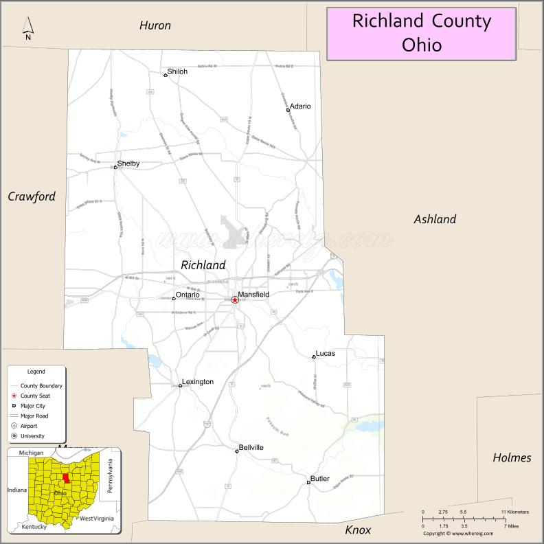
About Richland County Map, Ohio: The map showing the county boundary, county seat, major cities, highways, water bodies and neighbouring counties.
Ohio More Maps & Info
About Richland County, Ohio
Richland County is a county located in the U.S. state of Ohio. It's county seat is Mansfield. As per 2020 census, the population of Richland County is 125195 people and population density is square miles. According to the United States Census Bureau, the county has a total area of 496.88 sq mi (1,287 km2). Richland County was established on -33541.
Richland County Facts
| Continent | North America |
| Country | United States |
| State | Ohio |
| County Seat | Mansfield |
| Largest City/Town | Mansfield |
| Established | March 1, 1808 |
| Total Area | 500 sq mi (1,295 sq km) |
| Land Area | 496 sq mi (1,285 sq km) |
| Water Area | 4.2 sq mi (10.9 sq km) |
| Population | 124,936 (Census 2020) |
| Population Density | 252 people per sq mi |
| Time Zone | Eastern Time Zone (ET) |
| Major Highways | I-71, US-30, US-42, State Route 13, State Route 39 |
| Neighboring Counties | Huron County, Ashland County, Knox County, Morrow County, Crawford County |
| Famous For | Ohio State Reformatory, manufacturing, parks and trails |
| Top Attractions | Ohio State Reformatory, Malabar Farm State Park, Kingwood Center Gardens, Richland Carrousel Park |
| Official Website | https://www.richlandcountyoh.gov/ |
Cities and Towns in Richland County, Ohio
- Mansfield (county seat) – 47,534 (Census 2020)
- Shelby – 8,990 (Census 2020)
- Ontario – 6,433 (Census 2020)
- Bellville – 1,847 (Census 2020)
Roads and Highways in Richland County, Ohio
Richland County is well connected by highways that link it to central and northern Ohio.
- I-71 – major north-south interstate connecting Cleveland to Columbus
- US-30 – east-west highway linking Mansfield to Wooster and Bucyrus
- US-42 – connects Mansfield to Ashland and Delaware
- State Route 13 – runs north-south linking Mansfield to Mount Vernon and Bellville
- State Route 39 – connects Mansfield to Shelby and eastern communities
Neighboring Counties of Richland County
- Huron County (north)
- Crawford County (northwest)
- Ashland County (west)
- Morrow County (south)
- Knox County (southeast)
Top Attractions in Richland County, Ohio
Richland County offers historic sites, parks, and family-friendly attractions.
- Ohio State Reformatory – historic prison featured in films and tours
- Malabar Farm State Park – scenic park with hiking, farming history, and events
- Kingwood Center Gardens – beautiful gardens with seasonal displays
- Richland Carrousel Park – unique indoor carousel attraction
- Snow Trails Ski Resort – winter sports destination near Mansfield
- Gorman Nature Center – outdoor education and nature trails
- Downtown Mansfield – historic area with shops and restaurants
- Charles Mill Lake Park – popular for boating and camping
Distance from Richland County to Nearby Cities
- Richland County to Columbus – 65 mi (105 km)
- Richland County to Cleveland – 70 mi (113 km)
- Richland County to Akron – 60 mi (97 km)
- Richland County to Toledo – 95 mi (153 km)
- Richland County to Mansfield – 0 mi (0 km)
FAQs about Richland County
Richland County is located in north-central Ohio.
It is known for the Ohio State Reformatory, parks, and manufacturing history.
The population was 124,936 according to the 2020 Census.
The county seat is Mansfield.
Yes, the county offers historic sites, parks, and recreational attractions.
- Adams County Map
- Allen County Map
- Ashland County Map
- Ashtabula County Map
- Athens County Map
- Auglaize County Map
- Belmont County Map
- Brown County Map
- Butler County Map
- Carroll County Map
- Champaign County Map
- Clark County Map
- Clermont County Map
- Clinton County Map
- Columbiana County Map
- Coshocton County Map
- Crawford County Map
- Cuyahoga County Map
- Darke County Map
- Defiance County Map
- Delaware County Map
- Erie County Map
- Fairfield County Map
- Fayette County Map
- Franklin County Map
- Fulton County Map
- Gallia County Map
- Geauga County Map
- Greene County Map
- Guernsey County Map
- Hamilton County Map
- Hancock County Map
- Hardin County Map
- Harrison County Map
- Henry County Map
- Highland County Map
- Hocking County Map
- Holmes County Map
- Huron County Map
- Jackson County Map
- Jefferson County Map
- Knox County Map
- Lake County Map
- Lawrence County Map
- Licking County Map
- Logan County Map
- Lorain County Map
- Lucas County Map
- Madison County Map
- Mahoning County Map
- Marion County Map
- Medina County Map
- Meigs County Map
- Mercer County Map
- Miami County Map
- Monroe County Map
- Montgomery County Map
- Morgan County Map
- Morrow County Map
- Muskingum County Map
- Noble County Map
- Ottawa County Map
- Paulding County Map
- Perry County Map
- Pickaway County Map
- Pike County Map
- Portage County Map
- Preble County Map
- Putnam County Map
- Richland County Map
- Ross County Map
- Sandusky County Map
- Scioto County Map
- Seneca County Map
- Shelby County Map
- Stark County Map
- Summit County Map
- Trumbull County Map
- Tuscarawas County Map
- Union County Map
- Van Wert County Map
- Vinton County Map
- Warren County Map
- Washington County Map
- Wayne County Map
- Williams County Map
- Wood County Map
- Wyandot County Map
- Alabama Counties
- Alaska boroughs
- Arizona Counties
- Arkansas Counties
- California County Map
- Colorado Counties
- Connecticut Counties
- Delaware Counties
- Florida County Map
- Georgia County Map
- Hawaii Counties
- Idaho Counties
- Illinois Counties
- Indiana Counties
- Iowa Counties
- Kansas Counties
- Kentucky Counties
- Louisiana Counties
- Maine Counties
- Maryland Counties
- Massachusetts Counties
- Michigan County Map
- Minnesota Counties
- Mississippi Counties
- Missouri Counties
- Montana Counties
- Nebraska Counties
- Nevada Counties
- New York Counties
- New Hampshire Counties
- New Jersey Counties
- New Mexico Counties
- North Carolina Counties
- North Dakota Counties
- Ohio County Map
- Oklahoma Counties
- Oregon Counties
- Pennsylvania Counties
- Rhode Island Counties
- South Carolina Counties
- South Dakota Counties
- Map of Tennessee
- Texas County Map
- Utah Counties
- Vermont Counties
- Virginia Counties
- Washington Counties
- West Virginia Counties
- Wisconsin Counties
- Wyoming Counties