Map of Huron County - Huron County is a county located in the U.S. state of Ohio. Huron County Map showing cities, highways, important places and water bodies. Get Where is Huron County located in the map, major cities in Huron county, population, areas, and places of interest.
Map of Huron County, Ohio
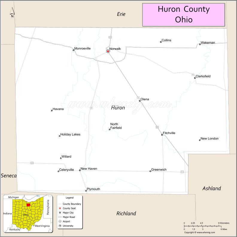
About Huron County Map, Ohio: The map showing the county boundary, county seat, major cities, highways, water bodies and neighbouring counties.
Ohio More Maps & Info
About Huron County, Ohio
Huron County is a county located in the U.S. state of Ohio. It's county seat is Norwalk. As per 2020 census, the population of Huron County is 58367 people and population density is square miles. According to the United States Census Bureau, the county has a total area of 492.69 sq mi (1,276 km2). Huron County was established on -33170.
Huron County Facts
| Continent | North America |
| Country | United States |
| State | Ohio |
| County Seat | Norwalk |
| Largest City/Town | Norwalk |
| Established | February 7, 1809 |
| Total Area | 495 sq mi (1,282 sq km) |
| Land Area | 492 sq mi (1,274 sq km) |
| Water Area | 3.3 sq mi (8.5 sq km) |
| Population | 58,565 (Census 2020) |
| Population Density | 119 people per sq mi |
| Time Zone | Eastern Time Zone (ET) |
| Major Highways | I-80/I-90 (Ohio Turnpike), US-20, US-250, State Route 18, State Route 61, State Route 103 |
| Neighboring Counties | Erie County, Lorain County, Ashland County, Richland County, Seneca County, Sandusky County |
| Famous For | Agriculture, Norwalk Raceway Park, rural landscapes |
| Top Attractions | Norwalk Raceway Park, Summit Motorsports Park, Veterans Memorial Lake Park, Huron County Historical Society |
| Official Website | https://huroncountyohio.gov/ |
Cities and Towns in Huron County, Ohio
- Norwalk (county seat) – 17,068 (Census 2020)
- Bellevue (partly) – 8,451 (Census 2020)
- Willard – 6,280 (Census 2020)
- Wakeman – 1,047 (Census 2020)
Roads and Highways in Huron County, Ohio
Huron County is connected by major highways that provide access across northern Ohio and to nearby regions.
- I-80/I-90 (Ohio Turnpike) – major east-west toll road connecting Cleveland to Toledo
- US-20 – runs east-west linking Norwalk to Sandusky and Lorain
- US-250 – connects Norwalk to Sandusky and southern Ohio
- State Route 18 – east-west route connecting Norwalk to Tiffin and Medina
- State Route 61 – north-south highway linking Norwalk to Ashland and Lake Erie
- State Route 103 – connects Willard to southern parts of the county
Neighboring Counties of Huron County
- Erie County (north)
- Lorain County (east)
- Ashland County (south)
- Richland County (southwest)
- Seneca County (west)
- Sandusky County (northwest)
Top Attractions in Huron County, Ohio
Huron County offers outdoor recreation, motorsports attractions, and local history sites.
- Summit Motorsports Park – well-known drag racing facility
- Norwalk Raceway Park – popular destination for racing events
- Veterans Memorial Lake Park – scenic park with a lake and trails
- Huron County Historical Society Museum – showcases local history
- Shady Lane Park – family-friendly park with recreational areas
- Willard Reservoir – quiet spot for fishing and relaxation
- Uptown Norwalk – historic downtown with shops and restaurants
- Maple Grove Park – community park with green space and activities
Distance from Huron County to Nearby Cities
- Huron County to Cleveland – 60 mi (97 km)
- Huron County to Toledo – 70 mi (113 km)
- Huron County to Columbus – 95 mi (153 km)
- Huron County to Mansfield – 35 mi (56 km)
- Huron County to Sandusky – 15 mi (24 km)
FAQs about Huron County
Huron County is located in north-central Ohio.
It is known for agriculture, motorsports parks, and rural landscapes.
The population was 58,565 according to the 2020 Census.
The county seat is Norwalk.
Yes, the county has parks, racing venues, and historical sites.
- Adams County Map
- Allen County Map
- Ashland County Map
- Ashtabula County Map
- Athens County Map
- Auglaize County Map
- Belmont County Map
- Brown County Map
- Butler County Map
- Carroll County Map
- Champaign County Map
- Clark County Map
- Clermont County Map
- Clinton County Map
- Columbiana County Map
- Coshocton County Map
- Crawford County Map
- Cuyahoga County Map
- Darke County Map
- Defiance County Map
- Delaware County Map
- Erie County Map
- Fairfield County Map
- Fayette County Map
- Franklin County Map
- Fulton County Map
- Gallia County Map
- Geauga County Map
- Greene County Map
- Guernsey County Map
- Hamilton County Map
- Hancock County Map
- Hardin County Map
- Harrison County Map
- Henry County Map
- Highland County Map
- Hocking County Map
- Holmes County Map
- Huron County Map
- Jackson County Map
- Jefferson County Map
- Knox County Map
- Lake County Map
- Lawrence County Map
- Licking County Map
- Logan County Map
- Lorain County Map
- Lucas County Map
- Madison County Map
- Mahoning County Map
- Marion County Map
- Medina County Map
- Meigs County Map
- Mercer County Map
- Miami County Map
- Monroe County Map
- Montgomery County Map
- Morgan County Map
- Morrow County Map
- Muskingum County Map
- Noble County Map
- Ottawa County Map
- Paulding County Map
- Perry County Map
- Pickaway County Map
- Pike County Map
- Portage County Map
- Preble County Map
- Putnam County Map
- Richland County Map
- Ross County Map
- Sandusky County Map
- Scioto County Map
- Seneca County Map
- Shelby County Map
- Stark County Map
- Summit County Map
- Trumbull County Map
- Tuscarawas County Map
- Union County Map
- Van Wert County Map
- Vinton County Map
- Warren County Map
- Washington County Map
- Wayne County Map
- Williams County Map
- Wood County Map
- Wyandot County Map
- Alabama Counties
- Alaska boroughs
- Arizona Counties
- Arkansas Counties
- California County Map
- Colorado Counties
- Connecticut Counties
- Delaware Counties
- Florida County Map
- Georgia County Map
- Hawaii Counties
- Idaho Counties
- Illinois Counties
- Indiana Counties
- Iowa Counties
- Kansas Counties
- Kentucky Counties
- Louisiana Counties
- Maine Counties
- Maryland Counties
- Massachusetts Counties
- Michigan County Map
- Minnesota Counties
- Mississippi Counties
- Missouri Counties
- Montana Counties
- Nebraska Counties
- Nevada Counties
- New York Counties
- New Hampshire Counties
- New Jersey Counties
- New Mexico Counties
- North Carolina Counties
- North Dakota Counties
- Ohio County Map
- Oklahoma Counties
- Oregon Counties
- Pennsylvania Counties
- Rhode Island Counties
- South Carolina Counties
- South Dakota Counties
- Map of Tennessee
- Texas County Map
- Utah Counties
- Vermont Counties
- Virginia Counties
- Washington Counties
- West Virginia Counties
- Wisconsin Counties
- Wyoming Counties