Map of Seneca County - Seneca County is a county located in the U.S. state of Ohio. Seneca County Map showing cities, highways, important places and water bodies. Get Where is Seneca County located in the map, major cities in Seneca county, population, areas, and places of interest.
Map of Seneca County, Ohio
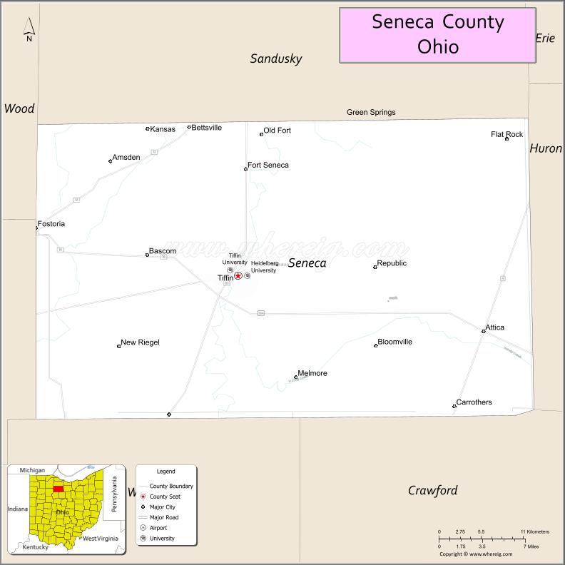
About Seneca County Map, Ohio: The map showing the county boundary, county seat, major cities, highways, water bodies and neighbouring counties.
Ohio More Maps & Info
About Seneca County, Ohio
Seneca County is a county located in the U.S. state of Ohio. It's county seat is Tiffin. As per 2020 census, the population of Seneca County is 54906 people and population density is square miles. According to the United States Census Bureau, the county has a total area of 550.59 sq mi (1,426 km2). Seneca County was established on -29127.
Seneca County Facts
| Continent | North America |
| Country | United States |
| State | Ohio |
| County Seat | Tiffin |
| Largest City/Town | Tiffin |
| Established | February 12, 1820 |
| Total Area | 553 sq mi (1,432 sq km) |
| Land Area | 551 sq mi (1,427 sq km) |
| Water Area | 2.1 sq mi (5.4 sq km) |
| Population | 55,069 (Census 2020) |
| Population Density | 100 people per sq mi |
| Time Zone | Eastern Time Zone (ET) |
| Major Highways | US-224, US-23, State Route 18, State Route 53, State Route 4 |
| Neighboring Counties | Sandusky County, Huron County, Crawford County, Wyandot County, Hancock County, Wood County |
| Famous For | Tiffin University, Heidelberg University, agriculture |
| Top Attractions | Hedges-Boyer Park, Seneca Caverns, Tiffin Glass Museum, Sandusky River |
| Official Website | https://senecacountyohio.gov/ |
Cities and Towns in Seneca County, Ohio
- Tiffin (county seat) – 17,963 (Census 2020)
- Fostoria (partly) – 13,046 (Census 2020)
- Attica – 899 (Census 2020)
- Bloomville – 967 (Census 2020)
Roads and Highways in Seneca County, Ohio
Seneca County is connected by highways that link it to north-central and northwest Ohio.
- US-224 – major east-west route connecting Tiffin to Findlay and Bucyrus
- US-23 – runs north-south linking the county to Toledo and Columbus
- State Route 18 – connects Tiffin to Norwalk and Fostoria
- State Route 53 – runs north-south connecting Tiffin to Fremont and Upper Sandusky
- State Route 4 – links the county to Bucyrus and Sandusky
Neighboring Counties of Seneca County
- Sandusky County (north)
- Huron County (northeast)
- Crawford County (east)
- Wyandot County (south)
- Hancock County (west)
- Wood County (northwest)
Top Attractions in Seneca County, Ohio
Seneca County offers a mix of educational, historical, and outdoor attractions.
- Seneca Caverns – underground caves with guided tours
- Hedges-Boyer Park – popular park with trails and sports facilities
- Tiffin Glass Museum – showcases historic glassmaking
- Heidelberg University campus – scenic grounds and cultural events
- Tiffin University – educational institution with local events
- Sandusky River – scenic waterway for outdoor recreation
- Fort Ball Historic Site nearby – historic military site
- Downtown Tiffin – charming area with shops and restaurants
Distance from Seneca County to Nearby Cities
- Seneca County to Toledo – 50 mi (80 km)
- Seneca County to Columbus – 100 mi (161 km)
- Seneca County to Cleveland – 90 mi (145 km)
- Seneca County to Findlay – 25 mi (40 km)
- Seneca County to Mansfield – 50 mi (80 km)
FAQs about Seneca County
Seneca County is located in north-central Ohio.
It is known for its universities, agriculture, and historic attractions.
The population was 55,069 according to the 2020 Census.
The county seat is Tiffin.
Yes, the county offers parks, museums, and natural attractions.
- Adams County Map
- Allen County Map
- Ashland County Map
- Ashtabula County Map
- Athens County Map
- Auglaize County Map
- Belmont County Map
- Brown County Map
- Butler County Map
- Carroll County Map
- Champaign County Map
- Clark County Map
- Clermont County Map
- Clinton County Map
- Columbiana County Map
- Coshocton County Map
- Crawford County Map
- Cuyahoga County Map
- Darke County Map
- Defiance County Map
- Delaware County Map
- Erie County Map
- Fairfield County Map
- Fayette County Map
- Franklin County Map
- Fulton County Map
- Gallia County Map
- Geauga County Map
- Greene County Map
- Guernsey County Map
- Hamilton County Map
- Hancock County Map
- Hardin County Map
- Harrison County Map
- Henry County Map
- Highland County Map
- Hocking County Map
- Holmes County Map
- Huron County Map
- Jackson County Map
- Jefferson County Map
- Knox County Map
- Lake County Map
- Lawrence County Map
- Licking County Map
- Logan County Map
- Lorain County Map
- Lucas County Map
- Madison County Map
- Mahoning County Map
- Marion County Map
- Medina County Map
- Meigs County Map
- Mercer County Map
- Miami County Map
- Monroe County Map
- Montgomery County Map
- Morgan County Map
- Morrow County Map
- Muskingum County Map
- Noble County Map
- Ottawa County Map
- Paulding County Map
- Perry County Map
- Pickaway County Map
- Pike County Map
- Portage County Map
- Preble County Map
- Putnam County Map
- Richland County Map
- Ross County Map
- Sandusky County Map
- Scioto County Map
- Seneca County Map
- Shelby County Map
- Stark County Map
- Summit County Map
- Trumbull County Map
- Tuscarawas County Map
- Union County Map
- Van Wert County Map
- Vinton County Map
- Warren County Map
- Washington County Map
- Wayne County Map
- Williams County Map
- Wood County Map
- Wyandot County Map
- Alabama Counties
- Alaska boroughs
- Arizona Counties
- Arkansas Counties
- California County Map
- Colorado Counties
- Connecticut Counties
- Delaware Counties
- Florida County Map
- Georgia County Map
- Hawaii Counties
- Idaho Counties
- Illinois Counties
- Indiana Counties
- Iowa Counties
- Kansas Counties
- Kentucky Counties
- Louisiana Counties
- Maine Counties
- Maryland Counties
- Massachusetts Counties
- Michigan County Map
- Minnesota Counties
- Mississippi Counties
- Missouri Counties
- Montana Counties
- Nebraska Counties
- Nevada Counties
- New York Counties
- New Hampshire Counties
- New Jersey Counties
- New Mexico Counties
- North Carolina Counties
- North Dakota Counties
- Ohio County Map
- Oklahoma Counties
- Oregon Counties
- Pennsylvania Counties
- Rhode Island Counties
- South Carolina Counties
- South Dakota Counties
- Map of Tennessee
- Texas County Map
- Utah Counties
- Vermont Counties
- Virginia Counties
- Washington Counties
- West Virginia Counties
- Wisconsin Counties
- Wyoming Counties