Map of Medina County - Medina County is a county located in the U.S. state of Ohio. Medina County Map showing cities, highways, important places and water bodies. Get Where is Medina County located in the map, major cities in Medina county, population, areas, and places of interest.
Map of Medina County, Ohio
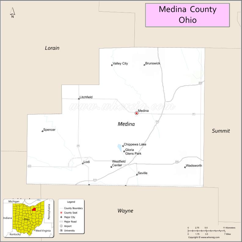
About Medina County Map, Ohio: The map showing the county boundary, county seat, major cities, highways, water bodies and neighbouring counties.
Ohio More Maps & Info
About Medina County, Ohio
Medina County is a county located in the U.S. state of Ohio. It's county seat is Medina. As per 2020 census, the population of Medina County is 183092 people and population density is square miles. According to the United States Census Bureau, the county has a total area of 423 sq mi (1,096 km2). Medina County was established on -32092.
Medina County Facts
| Continent | North America |
| Country | United States |
| State | Ohio |
| County Seat | Medina |
| Largest City/Town | Brunswick |
| Established | February 18, 1812 |
| Total Area | 423 sq mi (1,096 sq km) |
| Land Area | 421 sq mi (1,091 sq km) |
| Water Area | 1.9 sq mi (4.9 sq km) |
| Population | 182,470 (Census 2020) |
| Population Density | 433 people per sq mi |
| Time Zone | Eastern Time Zone (ET) |
| Major Highways | I-71, I-76, US-42, US-224, State Route 3, State Route 18 |
| Neighboring Counties | Cuyahoga County, Summit County, Wayne County, Lorain County, Ashland County |
| Famous For | Suburban Cleveland growth, Medina Square, parks and farmland |
| Top Attractions | Medina Public Square, Castle Noel, Allardale Park, Buckeye Woods Park |
| Official Website | https://www.co.medina.oh.us/ |
Cities and Towns in Medina County, Ohio
- Medina (county seat) – 26,678 (Census 2020)
- Brunswick – 34,255 (Census 2020)
- Wadsworth – 24,007 (Census 2020)
- Lodi – 2,746 (Census 2020)
Roads and Highways in Medina County, Ohio
Medina County is well connected by highways that link it to Cleveland, Akron, and surrounding regions.
- I-71 – major north-south interstate connecting Cleveland to Columbus
- I-76 – runs east-west linking Akron to Youngstown and beyond
- US-42 – connects Medina to Cleveland and Cincinnati
- US-224 – east-west route linking the county to Akron and western Ohio
- State Route 3 – runs north-south connecting Medina to Cleveland and Wooster
- State Route 18 – connects Medina to Akron and surrounding communities
Neighboring Counties of Medina County
- Cuyahoga County (north)
- Lorain County (west)
- Wayne County (southwest)
- Ashland County (south)
- Summit County (east)
Top Attractions in Medina County, Ohio
Medina County offers a mix of historic charm, parks, and family-friendly attractions.
- Medina Public Square – historic town center with shops and events
- Castle Noel – unique Christmas-themed museum
- Allardale Park – scenic park with trails and wildlife
- Buckeye Woods Park – nature park with walking trails
- Medina Toy and Train Museum – collection of vintage toys and trains
- Hinckley Reservation nearby – popular park with trails and overlooks
- Wadsworth Historic District – charming downtown with shops and dining
- Chippewa Lake area – scenic lake and recreational spot
Distance from Medina County to Nearby Cities
- Medina County to Cleveland – 30 mi (48 km)
- Medina County to Akron – 20 mi (32 km)
- Medina County to Columbus – 110 mi (177 km)
- Medina County to Toledo – 100 mi (161 km)
- Medina County to Canton – 40 mi (64 km)
FAQs about Medina County
Medina County is located in northeastern Ohio, south of Cleveland.
It is known for Medina Square, suburban growth, and parks.
The population was 182,470 according to the 2020 Census.
The county seat is Medina.
Yes, the county has parks, museums, and historic downtown areas.
- Adams County Map
- Allen County Map
- Ashland County Map
- Ashtabula County Map
- Athens County Map
- Auglaize County Map
- Belmont County Map
- Brown County Map
- Butler County Map
- Carroll County Map
- Champaign County Map
- Clark County Map
- Clermont County Map
- Clinton County Map
- Columbiana County Map
- Coshocton County Map
- Crawford County Map
- Cuyahoga County Map
- Darke County Map
- Defiance County Map
- Delaware County Map
- Erie County Map
- Fairfield County Map
- Fayette County Map
- Franklin County Map
- Fulton County Map
- Gallia County Map
- Geauga County Map
- Greene County Map
- Guernsey County Map
- Hamilton County Map
- Hancock County Map
- Hardin County Map
- Harrison County Map
- Henry County Map
- Highland County Map
- Hocking County Map
- Holmes County Map
- Huron County Map
- Jackson County Map
- Jefferson County Map
- Knox County Map
- Lake County Map
- Lawrence County Map
- Licking County Map
- Logan County Map
- Lorain County Map
- Lucas County Map
- Madison County Map
- Mahoning County Map
- Marion County Map
- Medina County Map
- Meigs County Map
- Mercer County Map
- Miami County Map
- Monroe County Map
- Montgomery County Map
- Morgan County Map
- Morrow County Map
- Muskingum County Map
- Noble County Map
- Ottawa County Map
- Paulding County Map
- Perry County Map
- Pickaway County Map
- Pike County Map
- Portage County Map
- Preble County Map
- Putnam County Map
- Richland County Map
- Ross County Map
- Sandusky County Map
- Scioto County Map
- Seneca County Map
- Shelby County Map
- Stark County Map
- Summit County Map
- Trumbull County Map
- Tuscarawas County Map
- Union County Map
- Van Wert County Map
- Vinton County Map
- Warren County Map
- Washington County Map
- Wayne County Map
- Williams County Map
- Wood County Map
- Wyandot County Map
- Alabama Counties
- Alaska boroughs
- Arizona Counties
- Arkansas Counties
- California County Map
- Colorado Counties
- Connecticut Counties
- Delaware Counties
- Florida County Map
- Georgia County Map
- Hawaii Counties
- Idaho Counties
- Illinois Counties
- Indiana Counties
- Iowa Counties
- Kansas Counties
- Kentucky Counties
- Louisiana Counties
- Maine Counties
- Maryland Counties
- Massachusetts Counties
- Michigan County Map
- Minnesota Counties
- Mississippi Counties
- Missouri Counties
- Montana Counties
- Nebraska Counties
- Nevada Counties
- New York Counties
- New Hampshire Counties
- New Jersey Counties
- New Mexico Counties
- North Carolina Counties
- North Dakota Counties
- Ohio County Map
- Oklahoma Counties
- Oregon Counties
- Pennsylvania Counties
- Rhode Island Counties
- South Carolina Counties
- South Dakota Counties
- Map of Tennessee
- Texas County Map
- Utah Counties
- Vermont Counties
- Virginia Counties
- Washington Counties
- West Virginia Counties
- Wisconsin Counties
- Wyoming Counties