Map of Ashtabula County - Ashtabula County is a county located in the U.S. state of Ohio. Ashtabula County Map showing cities, highways, important places and water bodies. Get Where is Ashtabula County located in the map, major cities in Ashtabula county, population, areas, and places of interest.
Map of Ashtabula County, Ohio
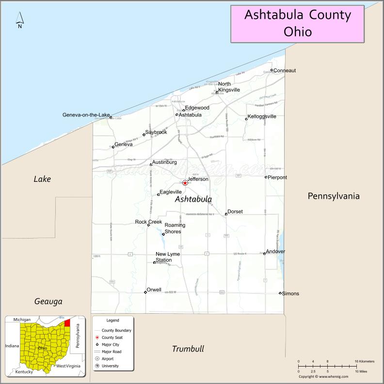
About Ashtabula County Map, Ohio: The map showing the county boundary, county seat, major cities, highways, water bodies and neighbouring counties.
Ohio More Maps & Info
About Ashtabula County, Ohio
Ashtabula County is a county located in the U.S. state of Ohio. It's county seat is Jefferson. As per 2020 census, the population of Ashtabula County is 97337 people and population density is square miles. According to the United States Census Bureau, the county has a total area of 702.44 sq mi (1,819 km2). Ashtabula County was established on -33809.
Ashtabula County Facts
| Continent | North America |
| Country | United States |
| State | Ohio |
| County Seat | Jefferson |
| Largest City/Town | Ashtabula |
| Established | 1807 |
| Total Area | 1,368 sq mi |
| Land Area | 702 sq mi |
| Water Area | 666 sq mi |
| Population | 97,574 (Census 2020) |
| Population Density | 139 people per sq mi |
| Time Zone | Eastern (EST) |
| Major Highways | I-90, US-20, SR-11, SR-45 |
| Neighboring Counties | Lake County (OH), Geauga County (OH), Trumbull County (OH), Crawford County (PA) |
| Famous For | Lake Erie shoreline, covered bridges, wineries |
| Top Attractions | Geneva-on-the-Lake, Ashtabula Harbor, Covered Bridges, Lake Erie coastline |
| Official Website | https://www.ashtabulacounty.us |
Cities and Towns in Ashtabula County, Ohio
- Jefferson (county seat) – 3,211 (Census 2020)
- Ashtabula – 17,975 (Census 2020)
- Geneva – 5,923 (Census 2020)
- Conneaut – 12,318 (Census 2020)
Roads and Highways in Ashtabula County, Ohio
Ashtabula County is located in northeastern Ohio and is well connected by interstate and state highways.
- Interstate 90 (I-90) – Major east-west route along Lake Erie connecting Cleveland and Pennsylvania
- U.S. Route 20 (US-20) – Runs parallel to Lake Erie through the county
- State Route 11 (SR-11) – North-south route connecting the county to Youngstown and southern Ohio
- State Route 45 (SR-45) – Connects Jefferson with surrounding communities
Neighboring Counties of Ashtabula County
- Lake County (west)
- Geauga County (southwest)
- Trumbull County (south)
- Crawford County, Pennsylvania (east)
Top Attractions in Ashtabula County, Ohio
Ashtabula County is known for its scenic Lake Erie shoreline, wineries, and historic covered bridges.
- Geneva-on-the-Lake – Popular lakeside resort town with entertainment and beaches
- Ashtabula Harbor – Historic waterfront district with shops and dining
- Ashtabula County Covered Bridges – Ohio’s largest collection of covered bridges
- Lake Erie shoreline – Beaches, fishing, and boating opportunities
- Ferrante Winery & Ristorante – Well-known local winery
- Harpersfield Covered Bridge Metropark – Scenic park with historic bridge
- Spire Institute – Sports training and competition facility
Distance from Ashtabula County to Nearby Cities
- Jefferson to Cleveland – 60 mi (97 km)
- Jefferson to Erie, PA – 40 mi (64 km)
- Jefferson to Youngstown – 65 mi (105 km)
- Jefferson to Buffalo, NY – 110 mi (177 km)
- Jefferson to Pittsburgh, PA – 150 mi (241 km)
FAQs about Ashtabula County
Ashtabula County is known for Lake Erie shoreline, covered bridges, and wineries.
Jefferson is the county seat of Ashtabula County.
Yes, it has a long shoreline along Lake Erie in northeastern Ohio.
Visitors enjoy Geneva-on-the-Lake, covered bridges, wineries, and the Lake Erie coast.
It is known for having the largest collection of covered bridges in Ohio.
- Adams County Map
- Allen County Map
- Ashland County Map
- Ashtabula County Map
- Athens County Map
- Auglaize County Map
- Belmont County Map
- Brown County Map
- Butler County Map
- Carroll County Map
- Champaign County Map
- Clark County Map
- Clermont County Map
- Clinton County Map
- Columbiana County Map
- Coshocton County Map
- Crawford County Map
- Cuyahoga County Map
- Darke County Map
- Defiance County Map
- Delaware County Map
- Erie County Map
- Fairfield County Map
- Fayette County Map
- Franklin County Map
- Fulton County Map
- Gallia County Map
- Geauga County Map
- Greene County Map
- Guernsey County Map
- Hamilton County Map
- Hancock County Map
- Hardin County Map
- Harrison County Map
- Henry County Map
- Highland County Map
- Hocking County Map
- Holmes County Map
- Huron County Map
- Jackson County Map
- Jefferson County Map
- Knox County Map
- Lake County Map
- Lawrence County Map
- Licking County Map
- Logan County Map
- Lorain County Map
- Lucas County Map
- Madison County Map
- Mahoning County Map
- Marion County Map
- Medina County Map
- Meigs County Map
- Mercer County Map
- Miami County Map
- Monroe County Map
- Montgomery County Map
- Morgan County Map
- Morrow County Map
- Muskingum County Map
- Noble County Map
- Ottawa County Map
- Paulding County Map
- Perry County Map
- Pickaway County Map
- Pike County Map
- Portage County Map
- Preble County Map
- Putnam County Map
- Richland County Map
- Ross County Map
- Sandusky County Map
- Scioto County Map
- Seneca County Map
- Shelby County Map
- Stark County Map
- Summit County Map
- Trumbull County Map
- Tuscarawas County Map
- Union County Map
- Van Wert County Map
- Vinton County Map
- Warren County Map
- Washington County Map
- Wayne County Map
- Williams County Map
- Wood County Map
- Wyandot County Map
- Alabama Counties
- Alaska boroughs
- Arizona Counties
- Arkansas Counties
- California County Map
- Colorado Counties
- Connecticut Counties
- Delaware Counties
- Florida County Map
- Georgia County Map
- Hawaii Counties
- Idaho Counties
- Illinois Counties
- Indiana Counties
- Iowa Counties
- Kansas Counties
- Kentucky Counties
- Louisiana Counties
- Maine Counties
- Maryland Counties
- Massachusetts Counties
- Michigan County Map
- Minnesota Counties
- Mississippi Counties
- Missouri Counties
- Montana Counties
- Nebraska Counties
- Nevada Counties
- New York Counties
- New Hampshire Counties
- New Jersey Counties
- New Mexico Counties
- North Carolina Counties
- North Dakota Counties
- Ohio County Map
- Oklahoma Counties
- Oregon Counties
- Pennsylvania Counties
- Rhode Island Counties
- South Carolina Counties
- South Dakota Counties
- Map of Tennessee
- Texas County Map
- Utah Counties
- Vermont Counties
- Virginia Counties
- Washington Counties
- West Virginia Counties
- Wisconsin Counties
- Wyoming Counties