Map of Lorain County - Lorain County is a county located in the U.S. state of Ohio. Lorain County Map showing cities, highways, important places and water bodies. Get Where is Lorain County located in the map, major cities in Lorain county, population, areas, and places of interest.
Map of Lorain County, Ohio
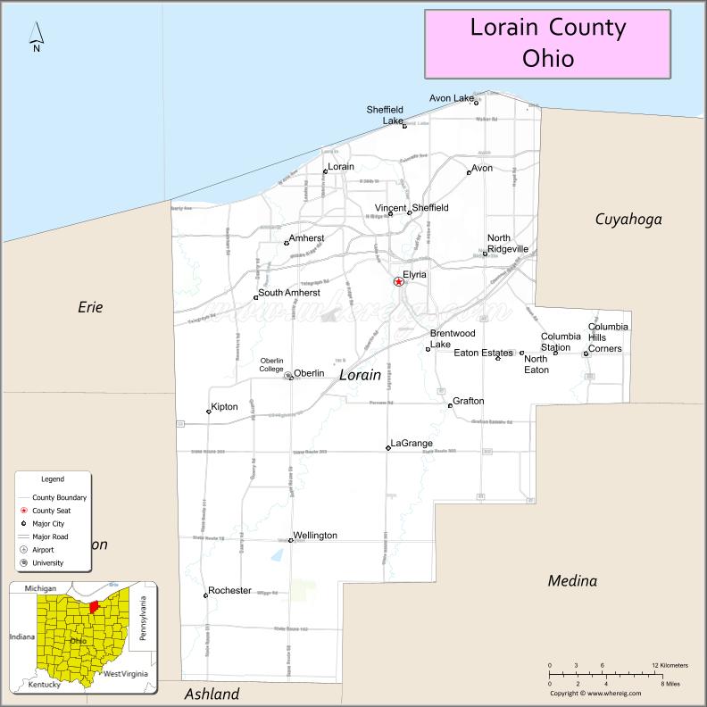
About Lorain County Map, Ohio: The map showing the county boundary, county seat, major cities, highways, water bodies and neighbouring counties.
Ohio More Maps & Info
About Lorain County, Ohio
Lorain County is a county located in the U.S. state of Ohio. It's county seat is Elyria. As per 2020 census, the population of Lorain County is 315595 people and population density is square miles. According to the United States Census Bureau, the county has a total area of 492.50 sq mi (1,276 km2). Lorain County was established on -28128.
Lorain County Facts
| Continent | North America |
| Country | United States |
| State | Ohio |
| County Seat | Elyria |
| Largest City/Town | Lorain |
| Established | December 26, 1822 |
| Total Area | 923 sq mi (2,390 sq km) |
| Land Area | 492 sq mi (1,274 sq km) |
| Water Area | 431 sq mi (1,116 sq km) |
| Population | 312,964 (Census 2020) |
| Population Density | 636 people per sq mi |
| Time Zone | Eastern Time Zone (ET) |
| Major Highways | I-90, I-80 (Ohio Turnpike), US-20, State Route 2, State Route 57, State Route 58 |
| Neighboring Counties | Cuyahoga County, Medina County, Ashland County, Huron County, Erie County |
| Famous For | Lake Erie shoreline, steel industry, parks and beaches |
| Top Attractions | Lakeview Park, Lorain Lighthouse, Black River Reservation, Oberlin College |
| Official Website | https://www.loraincounty.us/ |
Cities and Towns in Lorain County, Ohio
- Elyria (county seat) – 52,656 (Census 2020)
- Lorain – 65,211 (Census 2020)
- Avon – 25,206 (Census 2020)
- North Ridgeville – 35,280 (Census 2020)
Roads and Highways in Lorain County, Ohio
Lorain County is well connected by major highways that link it to Cleveland, Toledo, and other parts of northern Ohio.
- I-90 – major east-west interstate connecting Cleveland to Toledo
- I-80 (Ohio Turnpike) – toll road providing fast east-west travel across the state
- US-20 – historic route running through Elyria and surrounding areas
- State Route 2 – highway along Lake Erie connecting coastal communities
- State Route 57 – north-south route linking Elyria to Medina County
- State Route 58 – connects Amherst to Wellington and southern areas
Neighboring Counties of Lorain County
- Cuyahoga County (east)
- Medina County (south)
- Ashland County (southwest)
- Huron County (west)
- Erie County (northwest)
Top Attractions in Lorain County, Ohio
Lorain County offers lakeside attractions, parks, and cultural sites along Lake Erie.
- Lakeview Park – popular park with beach access and lake views
- Lorain Lighthouse – historic lighthouse known as the “Jewel of the Port”
- Black River Reservation – large park with trails and waterfalls
- Oberlin College – historic college with cultural events and museums
- Findley State Park – offers camping, boating, and hiking
- French Creek Reservation – nature preserve with scenic trails
- Downtown Elyria – historic area with shops and restaurants
- Amherst Sandstone Village – historic site showcasing local heritage
Distance from Lorain County to Nearby Cities
- Lorain County to Cleveland – 30 mi (48 km)
- Lorain County to Toledo – 90 mi (145 km)
- Lorain County to Akron – 40 mi (64 km)
- Lorain County to Sandusky – 40 mi (64 km)
- Lorain County to Columbus – 120 mi (193 km)
FAQs about Lorain County
Lorain County is located in northern Ohio along the southern shore of Lake Erie.
It is known for its Lake Erie shoreline, steel industry history, and parks.
The population was 312,964 according to the 2020 Census.
The county seat is Elyria.
Lorain is the largest city in the county.
- Adams County Map
- Allen County Map
- Ashland County Map
- Ashtabula County Map
- Athens County Map
- Auglaize County Map
- Belmont County Map
- Brown County Map
- Butler County Map
- Carroll County Map
- Champaign County Map
- Clark County Map
- Clermont County Map
- Clinton County Map
- Columbiana County Map
- Coshocton County Map
- Crawford County Map
- Cuyahoga County Map
- Darke County Map
- Defiance County Map
- Delaware County Map
- Erie County Map
- Fairfield County Map
- Fayette County Map
- Franklin County Map
- Fulton County Map
- Gallia County Map
- Geauga County Map
- Greene County Map
- Guernsey County Map
- Hamilton County Map
- Hancock County Map
- Hardin County Map
- Harrison County Map
- Henry County Map
- Highland County Map
- Hocking County Map
- Holmes County Map
- Huron County Map
- Jackson County Map
- Jefferson County Map
- Knox County Map
- Lake County Map
- Lawrence County Map
- Licking County Map
- Logan County Map
- Lorain County Map
- Lucas County Map
- Madison County Map
- Mahoning County Map
- Marion County Map
- Medina County Map
- Meigs County Map
- Mercer County Map
- Miami County Map
- Monroe County Map
- Montgomery County Map
- Morgan County Map
- Morrow County Map
- Muskingum County Map
- Noble County Map
- Ottawa County Map
- Paulding County Map
- Perry County Map
- Pickaway County Map
- Pike County Map
- Portage County Map
- Preble County Map
- Putnam County Map
- Richland County Map
- Ross County Map
- Sandusky County Map
- Scioto County Map
- Seneca County Map
- Shelby County Map
- Stark County Map
- Summit County Map
- Trumbull County Map
- Tuscarawas County Map
- Union County Map
- Van Wert County Map
- Vinton County Map
- Warren County Map
- Washington County Map
- Wayne County Map
- Williams County Map
- Wood County Map
- Wyandot County Map
- Alabama Counties
- Alaska boroughs
- Arizona Counties
- Arkansas Counties
- California County Map
- Colorado Counties
- Connecticut Counties
- Delaware Counties
- Florida County Map
- Georgia County Map
- Hawaii Counties
- Idaho Counties
- Illinois Counties
- Indiana Counties
- Iowa Counties
- Kansas Counties
- Kentucky Counties
- Louisiana Counties
- Maine Counties
- Maryland Counties
- Massachusetts Counties
- Michigan County Map
- Minnesota Counties
- Mississippi Counties
- Missouri Counties
- Montana Counties
- Nebraska Counties
- Nevada Counties
- New York Counties
- New Hampshire Counties
- New Jersey Counties
- New Mexico Counties
- North Carolina Counties
- North Dakota Counties
- Ohio County Map
- Oklahoma Counties
- Oregon Counties
- Pennsylvania Counties
- Rhode Island Counties
- South Carolina Counties
- South Dakota Counties
- Map of Tennessee
- Texas County Map
- Utah Counties
- Vermont Counties
- Virginia Counties
- Washington Counties
- West Virginia Counties
- Wisconsin Counties
- Wyoming Counties