Map of Columbiana County - Columbiana County is a county located in the U.S. state of Ohio. Columbiana County Map showing cities, highways, important places and water bodies. Get Where is Columbiana County located in the map, major cities in Columbiana county, population, areas, and places of interest.
Map of Columbiana County, Ohio
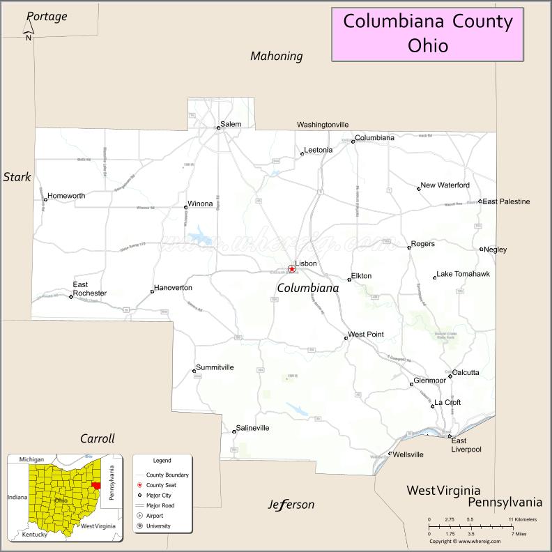
About Columbiana County Map, Ohio: The map showing the county boundary, county seat, major cities, highways, water bodies and neighbouring counties.
Ohio More Maps & Info
About Columbiana County, Ohio
Columbiana County is a county located in the U.S. state of Ohio. It's county seat is Lisbon. As per 2020 census, the population of Columbiana County is 101310 people and population density is square miles. According to the United States Census Bureau, the county has a total area of 532.46 sq mi (1,379 km2). Columbiana County was established on -35307.
Columbiana County Facts
| Continent | North America |
| Country | United States |
| State | Ohio |
| County Seat | Lisbon |
| Largest City/Town | Salem |
| Established | 1803 |
| Total Area | 538 sq mi |
| Land Area | 532 sq mi |
| Water Area | 6 sq mi |
| Population | 101,877 (Census 2020) |
| Population Density | 191 people per sq mi |
| Time Zone | Eastern Time Zone (ET) |
| Major Highways | US-30, US-62, SR-7, SR-11, SR-39 |
| Neighboring Counties | Mahoning County, Stark County, Carroll County, Jefferson County, Beaver County (PA), Lawrence County (PA), Washington County (PA) |
| Famous For | Pottery industry, historic towns, Ohio River access |
| Top Attractions | Beaver Creek State Park, Museum of Ceramics, The Links at Firestone Farms |
| Official Website | https://www.columbianacountyohio.gov |
Cities and Towns in Columbiana County, Ohio
- Lisbon (county seat) – 2,759 (Census 2020)
- Salem – 11,915 (Census 2020)
- East Liverpool – 9,958 (Census 2020)
- Columbiana – 6,559 (Census 2020)
Roads and Highways in Columbiana County, Ohio
Columbiana County is served by several major highways that connect it to neighboring Ohio counties and Pennsylvania.
- US Highway 30 – runs east-west connecting the county to Canton (west) and Pittsburgh, Pennsylvania (east)
- US Highway 62 – runs northwest-southeast connecting Salem to Alliance and Youngstown
- State Route 7 – follows the Ohio River connecting East Liverpool to Steubenville (south) and Youngstown (north)
- State Route 11 – north-south highway connecting the county to Youngstown (north) and East Liverpool (south)
- State Route 39 – connects Lisbon to New Philadelphia (west) and Wellsville (east)
Neighboring Counties of Columbiana County
- Mahoning County (north)
- Stark County (west)
- Carroll County (southwest)
- Jefferson County (south)
- Beaver County, Pennsylvania (east)
- Lawrence County, Pennsylvania (northeast)
- Washington County, Pennsylvania (east)
Top Attractions in Columbiana County, Ohio
Columbiana County offers historic sites, outdoor recreation, and a strong connection to its pottery heritage.
- Beaver Creek State Park – scenic park with trails, camping, and historic structures
- Museum of Ceramics – highlights the county’s rich pottery and industrial history
- The Links at Firestone Farms – popular golf course with dining and shopping nearby
- East Liverpool Downtown – historic district known for its pottery past
- Little Beaver Creek Greenway Trail – great for biking and walking
- Guilford Lake State Park – offers boating, fishing, and picnicking
- Spread Eagle Tavern & Inn – historic tavern dating back to the early 1800s
- Salem Historical Society Museum – features local artifacts and exhibits
Distance from Columbiana County to Nearby Cities
- Lisbon to Youngstown – 25 mi (40 km)
- Lisbon to Canton – 50 mi (80 km)
- Lisbon to Pittsburgh – 40 mi (64 km)
- Lisbon to Cleveland – 95 mi (153 km)
- Lisbon to Columbus – 150 mi (241 km)
FAQs about Columbiana County
Columbiana County is located in eastern Ohio along the Pennsylvania border.
It is known for its pottery industry, historic towns, and access to the Ohio River.
The population was 101,877 according to the 2020 Census.
The county seat is Lisbon.
Top attractions include Beaver Creek State Park, the Museum of Ceramics, and The Links at Firestone Farms.
- Adams County Map
- Allen County Map
- Ashland County Map
- Ashtabula County Map
- Athens County Map
- Auglaize County Map
- Belmont County Map
- Brown County Map
- Butler County Map
- Carroll County Map
- Champaign County Map
- Clark County Map
- Clermont County Map
- Clinton County Map
- Columbiana County Map
- Coshocton County Map
- Crawford County Map
- Cuyahoga County Map
- Darke County Map
- Defiance County Map
- Delaware County Map
- Erie County Map
- Fairfield County Map
- Fayette County Map
- Franklin County Map
- Fulton County Map
- Gallia County Map
- Geauga County Map
- Greene County Map
- Guernsey County Map
- Hamilton County Map
- Hancock County Map
- Hardin County Map
- Harrison County Map
- Henry County Map
- Highland County Map
- Hocking County Map
- Holmes County Map
- Huron County Map
- Jackson County Map
- Jefferson County Map
- Knox County Map
- Lake County Map
- Lawrence County Map
- Licking County Map
- Logan County Map
- Lorain County Map
- Lucas County Map
- Madison County Map
- Mahoning County Map
- Marion County Map
- Medina County Map
- Meigs County Map
- Mercer County Map
- Miami County Map
- Monroe County Map
- Montgomery County Map
- Morgan County Map
- Morrow County Map
- Muskingum County Map
- Noble County Map
- Ottawa County Map
- Paulding County Map
- Perry County Map
- Pickaway County Map
- Pike County Map
- Portage County Map
- Preble County Map
- Putnam County Map
- Richland County Map
- Ross County Map
- Sandusky County Map
- Scioto County Map
- Seneca County Map
- Shelby County Map
- Stark County Map
- Summit County Map
- Trumbull County Map
- Tuscarawas County Map
- Union County Map
- Van Wert County Map
- Vinton County Map
- Warren County Map
- Washington County Map
- Wayne County Map
- Williams County Map
- Wood County Map
- Wyandot County Map
- Alabama Counties
- Alaska boroughs
- Arizona Counties
- Arkansas Counties
- California County Map
- Colorado Counties
- Connecticut Counties
- Delaware Counties
- Florida County Map
- Georgia County Map
- Hawaii Counties
- Idaho Counties
- Illinois Counties
- Indiana Counties
- Iowa Counties
- Kansas Counties
- Kentucky Counties
- Louisiana Counties
- Maine Counties
- Maryland Counties
- Massachusetts Counties
- Michigan County Map
- Minnesota Counties
- Mississippi Counties
- Missouri Counties
- Montana Counties
- Nebraska Counties
- Nevada Counties
- New York Counties
- New Hampshire Counties
- New Jersey Counties
- New Mexico Counties
- North Carolina Counties
- North Dakota Counties
- Ohio County Map
- Oklahoma Counties
- Oregon Counties
- Pennsylvania Counties
- Rhode Island Counties
- South Carolina Counties
- South Dakota Counties
- Map of Tennessee
- Texas County Map
- Utah Counties
- Vermont Counties
- Virginia Counties
- Washington Counties
- West Virginia Counties
- Wisconsin Counties
- Wyoming Counties