Map of Fayette County - Fayette County is a county located in the U.S. state of Ohio. Fayette County Map showing cities, highways, important places and water bodies. Get Where is Fayette County located in the map, major cities in Fayette county, population, areas, and places of interest.
Map of Fayette County, Ohio
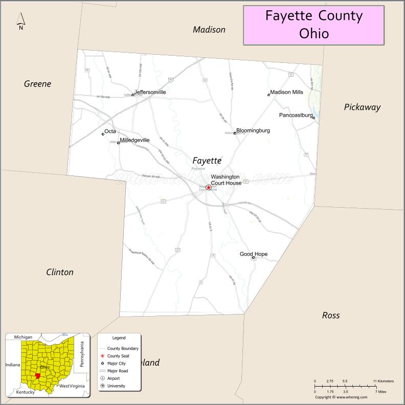
About Fayette County Map, Ohio: The map showing the county boundary, county seat, major cities, highways, water bodies and neighbouring counties.
Ohio More Maps & Info
About Fayette County, Ohio
Fayette County is a county located in the U.S. state of Ohio. It's county seat is Washington Court House. As per 2020 census, the population of Fayette County is 28906 people and population density is square miles. According to the United States Census Bureau, the county has a total area of 406.58 sq mi (1,053 km2). Fayette County was established on -32811.
Fayette County Facts
| Continent | North America |
| Country | United States |
| State | Ohio |
| County Seat | Washington Court House |
| Largest City/Town | Washington Court House |
| Established | May 1, 1810 |
| Total Area | 408 sq mi (1,057 sq km) |
| Land Area | 407 sq mi (1,054 sq km) |
| Water Area | 1.2 sq mi (3.1 sq km) |
| Population | 28,433 (Census 2020) |
| Population Density | 70 people per sq mi |
| Time Zone | Eastern Time Zone (ET) |
| Major Highways | US-22, US-35, State Route 41, State Route 38, State Route 734 |
| Neighboring Counties | Madison County, Pickaway County, Ross County, Highland County, Clinton County, Greene County |
| Famous For | Agriculture, rural landscapes, Washington Court House history |
| Top Attractions | Fayette County Fairgrounds, Carnegie Public Library, local parks and trails |
| Official Website | https://www.fayette-co-oh.com/ |
Cities and Towns in Fayette County, Ohio
- Washington Court House (county seat) – 14,995 (Census 2020)
- Jeffersonville – 1,258 (Census 2020)
- Bloomingburg – 938 (Census 2020)
- Octa – 77 (Census 2020)
Roads and Highways in Fayette County, Ohio
Fayette County is connected by several highways that support travel between central and southern Ohio.
- US-22 – east-west route connecting Washington Court House to Circleville and Wilmington
- US-35 – major route linking Dayton to Chillicothe through the county
- State Route 41 – runs north-south connecting Jeffersonville to Springfield
- State Route 38 – connects Washington Court House to London and Wilmington
- State Route 734 – links the county to Jeffersonville and nearby rural areas
Neighboring Counties of Fayette County
- Madison County (north)
- Pickaway County (northeast)
- Ross County (southeast)
- Highland County (southwest)
- Clinton County (west)
- Greene County (northwest)
Top Attractions in Fayette County, Ohio
Fayette County offers small-town charm with local events, parks, and historic spots to explore.
- Fayette County Fairgrounds – hosts one of the county’s biggest annual events
- Carnegie Public Library – historic building with local significance
- Washington Court House City Park – community park with walking paths and playgrounds
- Paint Creek – scenic waterway for fishing and relaxing
- Jeffersonville Outlet Area – nearby shopping and dining options
- Local historic downtown – small shops and local restaurants
- Bloomingburg Park – quiet place for outdoor activities
- Fayette County Museum – showcases local history and artifacts
Distance from Fayette County to Nearby Cities
- Fayette County to Columbus – 45 mi (72 km)
- Fayette County to Dayton – 55 mi (89 km)
- Fayette County to Chillicothe – 40 mi (64 km)
- Fayette County to Cincinnati – 70 mi (113 km)
- Fayette County to Springfield – 45 mi (72 km)
FAQs about Fayette County
Fayette County is located in southwestern Ohio between Columbus and Cincinnati.
It is known for its agricultural economy and small-town communities.
The population was 28,433 according to the 2020 Census.
The county seat is Washington Court House.
Yes, the Fayette County Fair is a major annual event along with other community gatherings.
- Adams County Map
- Allen County Map
- Ashland County Map
- Ashtabula County Map
- Athens County Map
- Auglaize County Map
- Belmont County Map
- Brown County Map
- Butler County Map
- Carroll County Map
- Champaign County Map
- Clark County Map
- Clermont County Map
- Clinton County Map
- Columbiana County Map
- Coshocton County Map
- Crawford County Map
- Cuyahoga County Map
- Darke County Map
- Defiance County Map
- Delaware County Map
- Erie County Map
- Fairfield County Map
- Fayette County Map
- Franklin County Map
- Fulton County Map
- Gallia County Map
- Geauga County Map
- Greene County Map
- Guernsey County Map
- Hamilton County Map
- Hancock County Map
- Hardin County Map
- Harrison County Map
- Henry County Map
- Highland County Map
- Hocking County Map
- Holmes County Map
- Huron County Map
- Jackson County Map
- Jefferson County Map
- Knox County Map
- Lake County Map
- Lawrence County Map
- Licking County Map
- Logan County Map
- Lorain County Map
- Lucas County Map
- Madison County Map
- Mahoning County Map
- Marion County Map
- Medina County Map
- Meigs County Map
- Mercer County Map
- Miami County Map
- Monroe County Map
- Montgomery County Map
- Morgan County Map
- Morrow County Map
- Muskingum County Map
- Noble County Map
- Ottawa County Map
- Paulding County Map
- Perry County Map
- Pickaway County Map
- Pike County Map
- Portage County Map
- Preble County Map
- Putnam County Map
- Richland County Map
- Ross County Map
- Sandusky County Map
- Scioto County Map
- Seneca County Map
- Shelby County Map
- Stark County Map
- Summit County Map
- Trumbull County Map
- Tuscarawas County Map
- Union County Map
- Van Wert County Map
- Vinton County Map
- Warren County Map
- Washington County Map
- Wayne County Map
- Williams County Map
- Wood County Map
- Wyandot County Map
- Alabama Counties
- Alaska boroughs
- Arizona Counties
- Arkansas Counties
- California County Map
- Colorado Counties
- Connecticut Counties
- Delaware Counties
- Florida County Map
- Georgia County Map
- Hawaii Counties
- Idaho Counties
- Illinois Counties
- Indiana Counties
- Iowa Counties
- Kansas Counties
- Kentucky Counties
- Louisiana Counties
- Maine Counties
- Maryland Counties
- Massachusetts Counties
- Michigan County Map
- Minnesota Counties
- Mississippi Counties
- Missouri Counties
- Montana Counties
- Nebraska Counties
- Nevada Counties
- New York Counties
- New Hampshire Counties
- New Jersey Counties
- New Mexico Counties
- North Carolina Counties
- North Dakota Counties
- Ohio County Map
- Oklahoma Counties
- Oregon Counties
- Pennsylvania Counties
- Rhode Island Counties
- South Carolina Counties
- South Dakota Counties
- Map of Tennessee
- Texas County Map
- Utah Counties
- Vermont Counties
- Virginia Counties
- Washington Counties
- West Virginia Counties
- Wisconsin Counties
- Wyoming Counties