Map of Tuscarawas County - Tuscarawas County is a county located in the U.S. state of Ohio. Tuscarawas County Map showing cities, highways, important places and water bodies. Get Where is Tuscarawas County located in the map, major cities in Tuscarawas county, population, areas, and places of interest.
Map of Tuscarawas County, Ohio
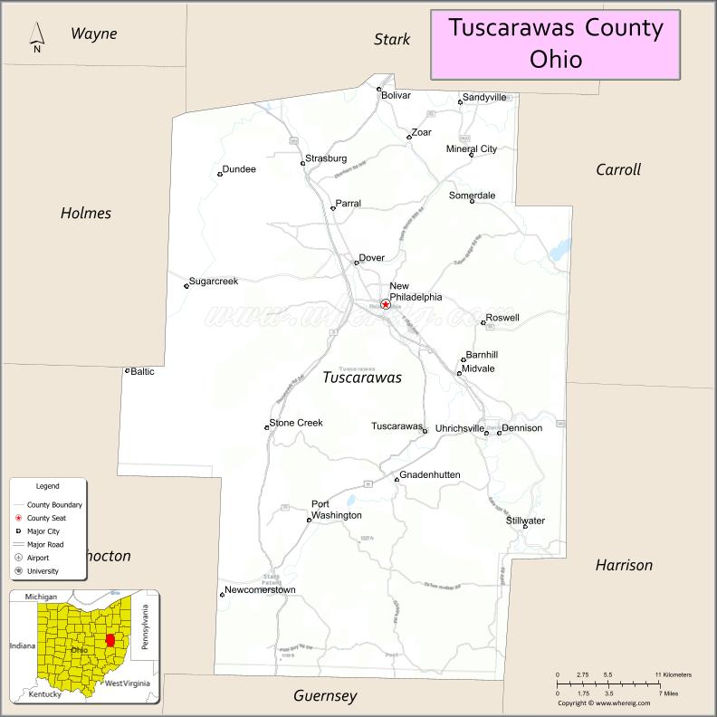
About Tuscarawas County Map, Ohio: The map showing the county boundary, county seat, major cities, highways, water bodies and neighbouring counties.
Ohio More Maps & Info
About Tuscarawas County, Ohio
Tuscarawas County is a county located in the U.S. state of Ohio. It's county seat is New Philadelphia. As per 2020 census, the population of Tuscarawas County is 92500 people and population density is square miles. According to the United States Census Bureau, the county has a total area of 567.58 sq mi (1,470 km2). Tuscarawas County was established on -33527.
Tuscarawas County Facts
| Continent | North America |
| Country | United States |
| State | Ohio |
| County Seat | New Philadelphia |
| Largest City/Town | New Philadelphia |
| Established | March 15, 1808 |
| Total Area | 571 sq mi (1,479 sq km) |
| Land Area | 568 sq mi (1,471 sq km) |
| Water Area | 3.8 sq mi (9.8 sq km) |
| Population | 93,263 (Census 2020) |
| Population Density | 164 people per sq mi |
| Time Zone | Eastern Time Zone (ET) |
| Major Highways | I-77, US-250, State Route 39, State Route 21, State Route 416 |
| Neighboring Counties | Stark County, Carroll County, Harrison County, Guernsey County, Coshocton County, Holmes County |
| Famous For | Historic canal system, Amish country, Schoenbrunn Village |
| Top Attractions | Schoenbrunn Village, Dennison Railroad Depot Museum, Tuscarawas River, Atwood Lake Park |
| Official Website | https://www.co.tuscarawas.oh.us/ |
Cities and Towns in Tuscarawas County, Ohio
- New Philadelphia (county seat) – 17,677 (Census 2020)
- Dover – 12,660 (Census 2020)
- Uhrichsville – 5,385 (Census 2020)
- Dennison – 2,655 (Census 2020)
Roads and Highways in Tuscarawas County, Ohio
Tuscarawas County is connected by highways that provide access to northeastern and southeastern Ohio.
- I-77 – major north-south interstate connecting Cleveland to Canton and beyond
- US-250 – east-west highway linking the county to Wooster and Wheeling, West Virginia
- State Route 39 – connects New Philadelphia to Millersburg and Carrollton
- State Route 21 – runs north-south linking the county to Akron and Massillon
- State Route 416 – connects local communities within the county
Neighboring Counties of Tuscarawas County
- Stark County (north)
- Carroll County (northeast)
- Harrison County (east)
- Guernsey County (south)
- Coshocton County (west)
- Holmes County (northwest)
Top Attractions in Tuscarawas County, Ohio
Tuscarawas County offers historic sites, outdoor recreation, and cultural attractions.
- Schoenbrunn Village – historic reconstructed Moravian settlement
- Dennison Railroad Depot Museum – museum showcasing railroad history
- Atwood Lake Park – popular for boating, fishing, and camping
- Tuscarawas River – scenic river for outdoor activities
- Warther Museum – displays carvings and trains created by Ernest Warther
- Dover Historic District – downtown area with shops and restaurants
- Zoar Village nearby – historic community with preserved buildings
- New Philadelphia parks – recreational spaces and community events
Distance from Tuscarawas County to Nearby Cities
- Tuscarawas County to Canton – 25 mi (40 km)
- Tuscarawas County to Akron – 50 mi (80 km)
- Tuscarawas County to Columbus – 100 mi (161 km)
- Tuscarawas County to Cleveland – 80 mi (129 km)
- Tuscarawas County to Pittsburgh – 90 mi (145 km)
FAQs about Tuscarawas County
Tuscarawas County is located in east-central Ohio.
It is known for its historic canal system, Amish country, and Schoenbrunn Village.
The population was 93,263 according to the 2020 Census.
The county seat is New Philadelphia.
Yes, the county offers historic sites, parks, and cultural attractions.
- Adams County Map
- Allen County Map
- Ashland County Map
- Ashtabula County Map
- Athens County Map
- Auglaize County Map
- Belmont County Map
- Brown County Map
- Butler County Map
- Carroll County Map
- Champaign County Map
- Clark County Map
- Clermont County Map
- Clinton County Map
- Columbiana County Map
- Coshocton County Map
- Crawford County Map
- Cuyahoga County Map
- Darke County Map
- Defiance County Map
- Delaware County Map
- Erie County Map
- Fairfield County Map
- Fayette County Map
- Franklin County Map
- Fulton County Map
- Gallia County Map
- Geauga County Map
- Greene County Map
- Guernsey County Map
- Hamilton County Map
- Hancock County Map
- Hardin County Map
- Harrison County Map
- Henry County Map
- Highland County Map
- Hocking County Map
- Holmes County Map
- Huron County Map
- Jackson County Map
- Jefferson County Map
- Knox County Map
- Lake County Map
- Lawrence County Map
- Licking County Map
- Logan County Map
- Lorain County Map
- Lucas County Map
- Madison County Map
- Mahoning County Map
- Marion County Map
- Medina County Map
- Meigs County Map
- Mercer County Map
- Miami County Map
- Monroe County Map
- Montgomery County Map
- Morgan County Map
- Morrow County Map
- Muskingum County Map
- Noble County Map
- Ottawa County Map
- Paulding County Map
- Perry County Map
- Pickaway County Map
- Pike County Map
- Portage County Map
- Preble County Map
- Putnam County Map
- Richland County Map
- Ross County Map
- Sandusky County Map
- Scioto County Map
- Seneca County Map
- Shelby County Map
- Stark County Map
- Summit County Map
- Trumbull County Map
- Tuscarawas County Map
- Union County Map
- Van Wert County Map
- Vinton County Map
- Warren County Map
- Washington County Map
- Wayne County Map
- Williams County Map
- Wood County Map
- Wyandot County Map
- Alabama Counties
- Alaska boroughs
- Arizona Counties
- Arkansas Counties
- California County Map
- Colorado Counties
- Connecticut Counties
- Delaware Counties
- Florida County Map
- Georgia County Map
- Hawaii Counties
- Idaho Counties
- Illinois Counties
- Indiana Counties
- Iowa Counties
- Kansas Counties
- Kentucky Counties
- Louisiana Counties
- Maine Counties
- Maryland Counties
- Massachusetts Counties
- Michigan County Map
- Minnesota Counties
- Mississippi Counties
- Missouri Counties
- Montana Counties
- Nebraska Counties
- Nevada Counties
- New York Counties
- New Hampshire Counties
- New Jersey Counties
- New Mexico Counties
- North Carolina Counties
- North Dakota Counties
- Ohio County Map
- Oklahoma Counties
- Oregon Counties
- Pennsylvania Counties
- Rhode Island Counties
- South Carolina Counties
- South Dakota Counties
- Map of Tennessee
- Texas County Map
- Utah Counties
- Vermont Counties
- Virginia Counties
- Washington Counties
- West Virginia Counties
- Wisconsin Counties
- Wyoming Counties