Map of Lake County - Lake County is a county located in the U.S. state of Ohio. Lake County Map showing cities, highways, important places and water bodies. Get Where is Lake County located in the map, major cities in Lake county, population, areas, and places of interest.
Map of Lake County, Ohio
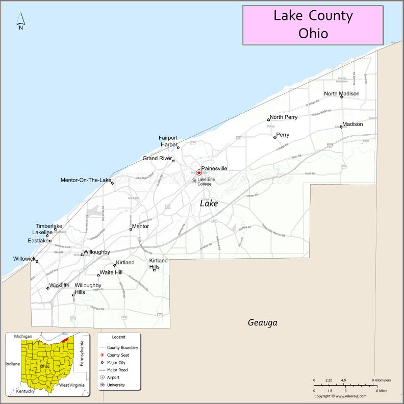
About Lake County Map, Ohio: The map showing the county boundary, county seat, major cities, highways, water bodies and neighbouring counties.
Ohio More Maps & Info
About Lake County, Ohio
Lake County is a county located in the U.S. state of Ohio. It's county seat is Painesville. As per 2020 census, the population of Lake County is 232023 people and population density is square miles. According to the United States Census Bureau, the county has a total area of 228.21 sq mi (591 km2). Lake County was established on -21848.
Lake County Facts
| Continent | North America |
| Country | United States |
| State | Ohio |
| County Seat | Painesville |
| Largest City/Town | Mentor |
| Established | March 6, 1840 |
| Total Area | 979 sq mi (2,536 sq km) |
| Land Area | 227 sq mi (588 sq km) |
| Water Area | 752 sq mi (1,948 sq km) |
| Population | 232,603 (Census 2020) |
| Population Density | 1,025 people per sq mi |
| Time Zone | Eastern Time Zone (ET) |
| Major Highways | I-90, State Route 2, US-20, State Route 44, State Route 84 |
| Neighboring Counties | Cuyahoga County, Geauga County, Ashtabula County |
| Famous For | Lake Erie shoreline, beaches, parks, suburban Cleveland area |
| Top Attractions | Headlands Beach State Park, Fairport Harbor Lighthouse, Mentor Lagoons, Holden Arboretum |
| Official Website | https://www.lakecountyohio.gov/ |
Cities and Towns in Lake County, Ohio
- Painesville (county seat) – 20,312 (Census 2020)
- Mentor – 47,450 (Census 2020)
- Willoughby – 23,959 (Census 2020)
- Eastlake – 17,670 (Census 2020)
Roads and Highways in Lake County, Ohio
Lake County is well connected by highways that run along Lake Erie and link it to Cleveland and northeastern Ohio.
- I-90 – major east-west interstate connecting Cleveland to Erie, Pennsylvania
- State Route 2 – runs along the Lake Erie shoreline connecting cities in the county
- US-20 – historic east-west route passing through several communities
- State Route 44 – north-south highway connecting Painesville to Geauga County
- State Route 84 – connects Mentor to inland communities
Neighboring Counties of Lake County
- Cuyahoga County (west)
- Geauga County (south)
- Ashtabula County (east)
Top Attractions in Lake County, Ohio
Lake County offers lakeside recreation, parks, and cultural attractions along the shores of Lake Erie.
- Headlands Beach State Park – largest natural beach in Ohio
- Fairport Harbor Lighthouse – historic lighthouse with museum
- Mentor Lagoons Nature Preserve – scenic area with trails and wetlands
- Holden Arboretum – one of the largest arboretums in the United States
- Lake Metroparks – system of parks with trails and nature centers
- Historic Kirtland – area known for religious and historical sites
- Indian Point Park – lakeside park with scenic views
- Grand River – popular for fishing and boating
Distance from Lake County to Nearby Cities
- Lake County to Cleveland – 25 mi (40 km)
- Lake County to Akron – 50 mi (80 km)
- Lake County to Erie – 70 mi (113 km)
- Lake County to Youngstown – 60 mi (97 km)
- Lake County to Columbus – 170 mi (274 km)
FAQs about Lake County
Lake County is located in northeastern Ohio along the southern shore of Lake Erie.
It is known for its Lake Erie shoreline, beaches, and parks.
The population was 232,603 according to the 2020 Census.
The county seat is Painesville.
Mentor is the largest city in the county.
- Adams County Map
- Allen County Map
- Ashland County Map
- Ashtabula County Map
- Athens County Map
- Auglaize County Map
- Belmont County Map
- Brown County Map
- Butler County Map
- Carroll County Map
- Champaign County Map
- Clark County Map
- Clermont County Map
- Clinton County Map
- Columbiana County Map
- Coshocton County Map
- Crawford County Map
- Cuyahoga County Map
- Darke County Map
- Defiance County Map
- Delaware County Map
- Erie County Map
- Fairfield County Map
- Fayette County Map
- Franklin County Map
- Fulton County Map
- Gallia County Map
- Geauga County Map
- Greene County Map
- Guernsey County Map
- Hamilton County Map
- Hancock County Map
- Hardin County Map
- Harrison County Map
- Henry County Map
- Highland County Map
- Hocking County Map
- Holmes County Map
- Huron County Map
- Jackson County Map
- Jefferson County Map
- Knox County Map
- Lake County Map
- Lawrence County Map
- Licking County Map
- Logan County Map
- Lorain County Map
- Lucas County Map
- Madison County Map
- Mahoning County Map
- Marion County Map
- Medina County Map
- Meigs County Map
- Mercer County Map
- Miami County Map
- Monroe County Map
- Montgomery County Map
- Morgan County Map
- Morrow County Map
- Muskingum County Map
- Noble County Map
- Ottawa County Map
- Paulding County Map
- Perry County Map
- Pickaway County Map
- Pike County Map
- Portage County Map
- Preble County Map
- Putnam County Map
- Richland County Map
- Ross County Map
- Sandusky County Map
- Scioto County Map
- Seneca County Map
- Shelby County Map
- Stark County Map
- Summit County Map
- Trumbull County Map
- Tuscarawas County Map
- Union County Map
- Van Wert County Map
- Vinton County Map
- Warren County Map
- Washington County Map
- Wayne County Map
- Williams County Map
- Wood County Map
- Wyandot County Map
- Alabama Counties
- Alaska boroughs
- Arizona Counties
- Arkansas Counties
- California County Map
- Colorado Counties
- Connecticut Counties
- Delaware Counties
- Florida County Map
- Georgia County Map
- Hawaii Counties
- Idaho Counties
- Illinois Counties
- Indiana Counties
- Iowa Counties
- Kansas Counties
- Kentucky Counties
- Louisiana Counties
- Maine Counties
- Maryland Counties
- Massachusetts Counties
- Michigan County Map
- Minnesota Counties
- Mississippi Counties
- Missouri Counties
- Montana Counties
- Nebraska Counties
- Nevada Counties
- New York Counties
- New Hampshire Counties
- New Jersey Counties
- New Mexico Counties
- North Carolina Counties
- North Dakota Counties
- Ohio County Map
- Oklahoma Counties
- Oregon Counties
- Pennsylvania Counties
- Rhode Island Counties
- South Carolina Counties
- South Dakota Counties
- Map of Tennessee
- Texas County Map
- Utah Counties
- Vermont Counties
- Virginia Counties
- Washington Counties
- West Virginia Counties
- Wisconsin Counties
- Wyoming Counties