Map of Wood County - Wood County is a county located in the U.S. state of Ohio. Wood County Map showing cities, highways, important places and water bodies. Get Where is Wood County located in the map, major cities in Wood county, population, areas, and places of interest.
Map of Wood County, Ohio
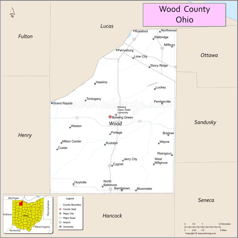
About Wood County Map, Ohio: The map showing the county boundary, county seat, major cities, highways, water bodies and neighbouring counties.
Ohio More Maps & Info
About Wood County, Ohio
Wood County is a county located in the U.S. state of Ohio. It's county seat is Bowling Green. As per 2020 census, the population of Wood County is 132472 people and population density is square miles. According to the United States Census Bureau, the county has a total area of 617.32 sq mi (1,599 km2). Wood County was established on -29127.
Wood County Facts
| Continent | North America |
| Country | United States |
| State | Ohio |
| County Seat | Bowling Green |
| Largest City/Town | Bowling Green |
| Established | February 12, 1820 |
| Total Area | 620 sq mi (1,606 sq km) |
| Land Area | 617 sq mi (1,598 sq km) |
| Water Area | 2.9 sq mi (7.5 sq km) |
| Population | 132,248 (Census 2020) |
| Population Density | 214 people per sq mi |
| Time Zone | Eastern Time Zone (ET) |
| Major Highways | I-75, US-6, US-20, State Route 25, State Route 199 |
| Neighboring Counties | Lucas County, Ottawa County, Sandusky County, Seneca County, Hancock County, Henry County |
| Famous For | Bowling Green State University, agriculture, Maumee River valley |
| Top Attractions | Bowling Green State University, Wood County Historical Center & Museum, Slippery Elm Trail, Bowling Green Wind Farm |
| Official Website | https://www.co.wood.oh.us/ |
Cities and Towns in Wood County, Ohio
- Bowling Green (county seat) – 30,028 (Census 2020)
- Rossford – 6,293 (Census 2020)
- North Baltimore – 3,432 (Census 2020)
- Perrysburg – 25,228 (Census 2020)
Roads and Highways in Wood County, Ohio
Wood County is a major transportation hub in northwest Ohio with strong interstate access.
- I-75 – major north-south interstate connecting Toledo to Cincinnati
- US-6 – east-west route connecting Toledo area to Sandusky and Cleveland region
- US-20 – major east-west highway across northern Ohio
- State Route 25 – connects Toledo to Bowling Green and further south
- State Route 199 – links Bowling Green to nearby rural communities
Neighboring Counties of Wood County
- Lucas County (north)
- Ottawa County (northeast)
- Sandusky County (east)
- Seneca County (southeast)
- Hancock County (south)
- Henry County (west)
Top Attractions in Wood County, Ohio
Wood County offers universities, trails, and cultural attractions.
- Bowling Green State University – major public university with cultural and sporting events
- Wood County Historical Center & Museum – local history exhibits and tours
- Slippery Elm Trail – scenic biking and walking trail
- Bowling Green Wind Farm – renewable energy site with wind turbines
- Perrysburg Historic District nearby – historic downtown area with shops
- Maumee River access – recreational fishing and boating
- Wintergarden/St. John’s Nature Preserve nearby – outdoor trails and nature
- Downtown Bowling Green – shops, dining, and local events
Distance from Wood County to Nearby Cities
- Wood County to Toledo – 25 mi (40 km)
- Wood County to Cleveland – 115 mi (185 km)
- Wood County to Detroit – 70 mi (113 km)
- Wood County to Columbus – 130 mi (209 km)
- Wood County to Fort Wayne – 110 mi (177 km)
FAQs about Wood County
Wood County is located in northwest Ohio.
It is known for Bowling Green State University, agriculture, and its location in the Maumee River valley.
The population was 132,248 according to the 2020 Census.
The county seat is Bowling Green.
Yes, Wood County offers universities, museums, trails, and historic districts.
- Adams County Map
- Allen County Map
- Ashland County Map
- Ashtabula County Map
- Athens County Map
- Auglaize County Map
- Belmont County Map
- Brown County Map
- Butler County Map
- Carroll County Map
- Champaign County Map
- Clark County Map
- Clermont County Map
- Clinton County Map
- Columbiana County Map
- Coshocton County Map
- Crawford County Map
- Cuyahoga County Map
- Darke County Map
- Defiance County Map
- Delaware County Map
- Erie County Map
- Fairfield County Map
- Fayette County Map
- Franklin County Map
- Fulton County Map
- Gallia County Map
- Geauga County Map
- Greene County Map
- Guernsey County Map
- Hamilton County Map
- Hancock County Map
- Hardin County Map
- Harrison County Map
- Henry County Map
- Highland County Map
- Hocking County Map
- Holmes County Map
- Huron County Map
- Jackson County Map
- Jefferson County Map
- Knox County Map
- Lake County Map
- Lawrence County Map
- Licking County Map
- Logan County Map
- Lorain County Map
- Lucas County Map
- Madison County Map
- Mahoning County Map
- Marion County Map
- Medina County Map
- Meigs County Map
- Mercer County Map
- Miami County Map
- Monroe County Map
- Montgomery County Map
- Morgan County Map
- Morrow County Map
- Muskingum County Map
- Noble County Map
- Ottawa County Map
- Paulding County Map
- Perry County Map
- Pickaway County Map
- Pike County Map
- Portage County Map
- Preble County Map
- Putnam County Map
- Richland County Map
- Ross County Map
- Sandusky County Map
- Scioto County Map
- Seneca County Map
- Shelby County Map
- Stark County Map
- Summit County Map
- Trumbull County Map
- Tuscarawas County Map
- Union County Map
- Van Wert County Map
- Vinton County Map
- Warren County Map
- Washington County Map
- Wayne County Map
- Williams County Map
- Wood County Map
- Wyandot County Map
- Alabama Counties
- Alaska boroughs
- Arizona Counties
- Arkansas Counties
- California County Map
- Colorado Counties
- Connecticut Counties
- Delaware Counties
- Florida County Map
- Georgia County Map
- Hawaii Counties
- Idaho Counties
- Illinois Counties
- Indiana Counties
- Iowa Counties
- Kansas Counties
- Kentucky Counties
- Louisiana Counties
- Maine Counties
- Maryland Counties
- Massachusetts Counties
- Michigan County Map
- Minnesota Counties
- Mississippi Counties
- Missouri Counties
- Montana Counties
- Nebraska Counties
- Nevada Counties
- New York Counties
- New Hampshire Counties
- New Jersey Counties
- New Mexico Counties
- North Carolina Counties
- North Dakota Counties
- Ohio County Map
- Oklahoma Counties
- Oregon Counties
- Pennsylvania Counties
- Rhode Island Counties
- South Carolina Counties
- South Dakota Counties
- Map of Tennessee
- Texas County Map
- Utah Counties
- Vermont Counties
- Virginia Counties
- Washington Counties
- West Virginia Counties
- Wisconsin Counties
- Wyoming Counties