Map of Warren County - Warren County is a county located in the U.S. state of Ohio. Warren County Map showing cities, highways, important places and water bodies. Get Where is Warren County located in the map, major cities in Warren county, population, areas, and places of interest.
Map of Warren County, Ohio
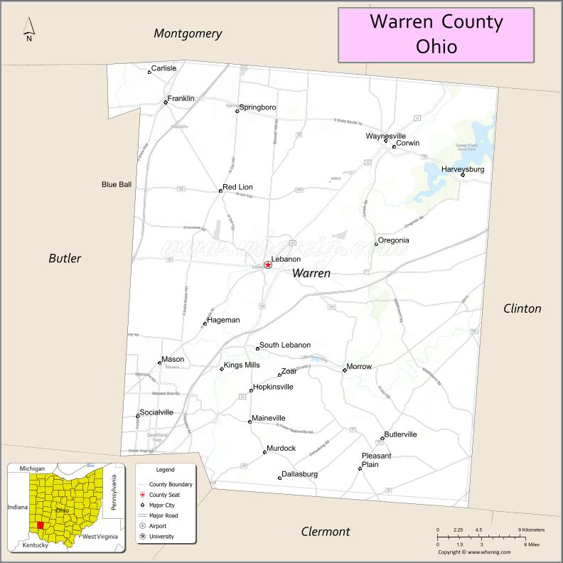
About Warren County Map, Ohio: The map showing the county boundary, county seat, major cities, highways, water bodies and neighbouring counties.
Ohio More Maps & Info
About Warren County, Ohio
Warren County is a county located in the U.S. state of Ohio. It's county seat is Lebanon. As per 2020 census, the population of Warren County is 246553 people and population density is square miles. According to the United States Census Bureau, the county has a total area of 399.63 sq mi (1,035 km2). Warren County was established on -35307.
Warren County Facts
| Continent | North America |
| Country | United States |
| State | Ohio |
| County Seat | Lebanon |
| Largest City/Town | Springboro |
| Established | May 1, 1803 |
| Total Area | 407 sq mi (1,054 sq km) |
| Land Area | 402 sq mi (1,041 sq km) |
| Water Area | 5.2 sq mi (13.5 sq km) |
| Population | 242,337 (Census 2020) |
| Population Density | 603 people per sq mi |
| Time Zone | Eastern Time Zone (ET) |
| Major Highways | I-71, I-75, US-42, US-22, State Route 48 |
| Neighboring Counties | Montgomery County, Butler County, Clermont County, Clinton County, Greene County, Hamilton County |
| Famous For | Amusement parks nearby, Kings Island, rapid suburban growth |
| Top Attractions | Kings Island, Lebanon Mason Monroe Railroad, Caesar Creek State Park, Warren County Historical Society |
| Official Website | https://www.co.warren.oh.us/ |
Cities and Towns in Warren County, Ohio
- Lebanon (county seat) – 20,841 (Census 2020)
- Springboro – 19,062 (Census 2020)
- Mason – 36,841 (Census 2020)
- Franklin – 12,786 (Census 2020)
Roads and Highways in Warren County, Ohio
Warren County is a major transportation hub in southwestern Ohio with strong interstate access.
- I-71 – connects Cincinnati to Columbus, passing through the county
- I-75 – major north-south interstate near the western edge of the county
- US-42 – runs through Lebanon and connects to Cincinnati and Xenia
- US-22 – east-west route linking Lebanon to Columbus region
- State Route 48 – connects Lebanon to Dayton and surrounding areas
Neighboring Counties of Warren County
- Clinton County (east)
- Greene County (northeast)
- Montgomery County (north)
- Butler County (west)
- Hamilton County (southwest)
- Clermont County (south)
Top Attractions in Warren County, Ohio
Warren County offers major attractions, parks, and historic sites.
- Kings Island – large amusement park with roller coasters and entertainment
- Caesar Creek State Park – popular for boating, hiking, and camping
- Lebanon Mason Monroe Railroad – historic scenic train rides
- Warren County Historical Society – museum showcasing local history
- Armco Park – recreational park with lake and trails
- Downtown Lebanon – historic district with shops and restaurants
- Little Miami Scenic Trail – biking and walking trail
- Fort Ancient Earthworks nearby – UNESCO World Heritage site
Distance from Warren County to Nearby Cities
- Warren County to Cincinnati – 30 mi (48 km)
- Warren County to Dayton – 25 mi (40 km)
- Warren County to Columbus – 75 mi (121 km)
- Warren County to Springfield – 35 mi (56 km)
- Warren County to Lexington, KY – 90 mi (145 km)
FAQs about Warren County
Warren County is located in southwestern Ohio between Cincinnati and Dayton.
It is known for Kings Island, rapid suburban growth, and major transportation routes.
The population was 242,337 according to the 2020 Census.
The county seat is Lebanon.
Yes, the county offers amusement parks, state parks, trails, and historic sites.
- Adams County Map
- Allen County Map
- Ashland County Map
- Ashtabula County Map
- Athens County Map
- Auglaize County Map
- Belmont County Map
- Brown County Map
- Butler County Map
- Carroll County Map
- Champaign County Map
- Clark County Map
- Clermont County Map
- Clinton County Map
- Columbiana County Map
- Coshocton County Map
- Crawford County Map
- Cuyahoga County Map
- Darke County Map
- Defiance County Map
- Delaware County Map
- Erie County Map
- Fairfield County Map
- Fayette County Map
- Franklin County Map
- Fulton County Map
- Gallia County Map
- Geauga County Map
- Greene County Map
- Guernsey County Map
- Hamilton County Map
- Hancock County Map
- Hardin County Map
- Harrison County Map
- Henry County Map
- Highland County Map
- Hocking County Map
- Holmes County Map
- Huron County Map
- Jackson County Map
- Jefferson County Map
- Knox County Map
- Lake County Map
- Lawrence County Map
- Licking County Map
- Logan County Map
- Lorain County Map
- Lucas County Map
- Madison County Map
- Mahoning County Map
- Marion County Map
- Medina County Map
- Meigs County Map
- Mercer County Map
- Miami County Map
- Monroe County Map
- Montgomery County Map
- Morgan County Map
- Morrow County Map
- Muskingum County Map
- Noble County Map
- Ottawa County Map
- Paulding County Map
- Perry County Map
- Pickaway County Map
- Pike County Map
- Portage County Map
- Preble County Map
- Putnam County Map
- Richland County Map
- Ross County Map
- Sandusky County Map
- Scioto County Map
- Seneca County Map
- Shelby County Map
- Stark County Map
- Summit County Map
- Trumbull County Map
- Tuscarawas County Map
- Union County Map
- Van Wert County Map
- Vinton County Map
- Warren County Map
- Washington County Map
- Wayne County Map
- Williams County Map
- Wood County Map
- Wyandot County Map
- Alabama Counties
- Alaska boroughs
- Arizona Counties
- Arkansas Counties
- California County Map
- Colorado Counties
- Connecticut Counties
- Delaware Counties
- Florida County Map
- Georgia County Map
- Hawaii Counties
- Idaho Counties
- Illinois Counties
- Indiana Counties
- Iowa Counties
- Kansas Counties
- Kentucky Counties
- Louisiana Counties
- Maine Counties
- Maryland Counties
- Massachusetts Counties
- Michigan County Map
- Minnesota Counties
- Mississippi Counties
- Missouri Counties
- Montana Counties
- Nebraska Counties
- Nevada Counties
- New York Counties
- New Hampshire Counties
- New Jersey Counties
- New Mexico Counties
- North Carolina Counties
- North Dakota Counties
- Ohio County Map
- Oklahoma Counties
- Oregon Counties
- Pennsylvania Counties
- Rhode Island Counties
- South Carolina Counties
- South Dakota Counties
- Map of Tennessee
- Texas County Map
- Utah Counties
- Vermont Counties
- Virginia Counties
- Washington Counties
- West Virginia Counties
- Wisconsin Counties
- Wyoming Counties