Map of Marion County - Marion County is a county located in the U.S. state of Ohio. Marion County Map showing cities, highways, important places and water bodies. Get Where is Marion County located in the map, major cities in Marion county, population, areas, and places of interest.
Map of Marion County, Ohio
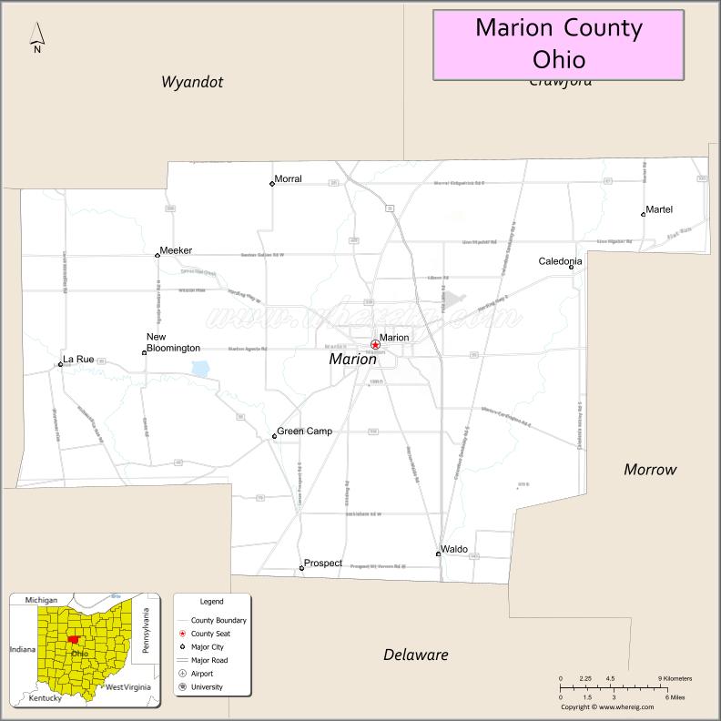
About Marion County Map, Ohio: The map showing the county boundary, county seat, major cities, highways, water bodies and neighbouring counties.
Ohio More Maps & Info
About Marion County, Ohio
Marion County is a county located in the U.S. state of Ohio. It's county seat is Marion. As per 2020 census, the population of Marion County is 65291 people and population density is square miles. According to the United States Census Bureau, the county has a total area of 403.84 sq mi (1,046 km2). Marion County was established on -29127.
Marion County Facts
| Continent | North America |
| Country | United States |
| State | Ohio |
| County Seat | Marion |
| Largest City/Town | Marion |
| Established | February 20, 1820 |
| Total Area | 404 sq mi (1,047 sq km) |
| Land Area | 403 sq mi (1,044 sq km) |
| Water Area | 1.5 sq mi (3.9 sq km) |
| Population | 65,359 (Census 2020) |
| Population Density | 162 people per sq mi |
| Time Zone | Eastern Time Zone (ET) |
| Major Highways | US-23, State Route 4, State Route 95, State Route 98, State Route 309 |
| Neighboring Counties | Hardin County, Wyandot County, Crawford County, Morrow County, Delaware County, Union County |
| Famous For | President Warren G. Harding, agriculture, rail history |
| Top Attractions | Harding Home and Memorial, Marion Tallgrass Trail, Wyandot Popcorn Museum, Quarry Park |
| Official Website | https://www.co.marion.oh.us/ |
Cities and Towns in Marion County, Ohio
- Marion (county seat) – 36,837 (Census 2020)
- Caledonia – 490 (Census 2020)
- La Rue – 735 (Census 2020)
- Prospect – 1,025 (Census 2020)
Roads and Highways in Marion County, Ohio
Marion County is served by several highways that connect it to central and northern Ohio.
- US-23 – major north-south route linking Marion to Columbus and Toledo
- State Route 4 – connects Marion to Bucyrus and Sandusky
- State Route 95 – east-west route connecting Marion to Mount Gilead and Kenton
- State Route 98 – runs north-south linking Marion to Bucyrus and Richwood
- State Route 309 – connects Marion to Kenton and Ontario
Neighboring Counties of Marion County
- Hardin County (northwest)
- Wyandot County (north)
- Crawford County (northeast)
- Morrow County (east)
- Delaware County (south)
- Union County (southwest)
Top Attractions in Marion County, Ohio
Marion County offers historic sites, parks, and local attractions centered around its rich heritage.
- Harding Home and Memorial – historic site of President Warren G. Harding
- Marion Tallgrass Trail – scenic trail for walking and biking
- Wyandot Popcorn Museum – unique museum dedicated to popcorn history
- Quarry Park – popular park with trails, lake, and climbing areas
- Marion Palace Theatre – historic theater with events and performances
- Lincoln Park – community park with recreational facilities
- Heritage Hall – museum showcasing local history
- Downtown Marion – historic area with shops and dining
Distance from Marion County to Nearby Cities
- Marion County to Columbus – 50 mi (80 km)
- Marion County to Toledo – 85 mi (137 km)
- Marion County to Mansfield – 30 mi (48 km)
- Marion County to Lima – 60 mi (97 km)
- Marion County to Cleveland – 100 mi (161 km)
FAQs about Marion County
Marion County is located in north-central Ohio.
It is known for President Warren G. Harding, agriculture, and local history.
The population was 65,359 according to the 2020 Census.
The county seat is Marion.
Yes, the county has historic sites, museums, and parks.
- Adams County Map
- Allen County Map
- Ashland County Map
- Ashtabula County Map
- Athens County Map
- Auglaize County Map
- Belmont County Map
- Brown County Map
- Butler County Map
- Carroll County Map
- Champaign County Map
- Clark County Map
- Clermont County Map
- Clinton County Map
- Columbiana County Map
- Coshocton County Map
- Crawford County Map
- Cuyahoga County Map
- Darke County Map
- Defiance County Map
- Delaware County Map
- Erie County Map
- Fairfield County Map
- Fayette County Map
- Franklin County Map
- Fulton County Map
- Gallia County Map
- Geauga County Map
- Greene County Map
- Guernsey County Map
- Hamilton County Map
- Hancock County Map
- Hardin County Map
- Harrison County Map
- Henry County Map
- Highland County Map
- Hocking County Map
- Holmes County Map
- Huron County Map
- Jackson County Map
- Jefferson County Map
- Knox County Map
- Lake County Map
- Lawrence County Map
- Licking County Map
- Logan County Map
- Lorain County Map
- Lucas County Map
- Madison County Map
- Mahoning County Map
- Marion County Map
- Medina County Map
- Meigs County Map
- Mercer County Map
- Miami County Map
- Monroe County Map
- Montgomery County Map
- Morgan County Map
- Morrow County Map
- Muskingum County Map
- Noble County Map
- Ottawa County Map
- Paulding County Map
- Perry County Map
- Pickaway County Map
- Pike County Map
- Portage County Map
- Preble County Map
- Putnam County Map
- Richland County Map
- Ross County Map
- Sandusky County Map
- Scioto County Map
- Seneca County Map
- Shelby County Map
- Stark County Map
- Summit County Map
- Trumbull County Map
- Tuscarawas County Map
- Union County Map
- Van Wert County Map
- Vinton County Map
- Warren County Map
- Washington County Map
- Wayne County Map
- Williams County Map
- Wood County Map
- Wyandot County Map
- Alabama Counties
- Alaska boroughs
- Arizona Counties
- Arkansas Counties
- California County Map
- Colorado Counties
- Connecticut Counties
- Delaware Counties
- Florida County Map
- Georgia County Map
- Hawaii Counties
- Idaho Counties
- Illinois Counties
- Indiana Counties
- Iowa Counties
- Kansas Counties
- Kentucky Counties
- Louisiana Counties
- Maine Counties
- Maryland Counties
- Massachusetts Counties
- Michigan County Map
- Minnesota Counties
- Mississippi Counties
- Missouri Counties
- Montana Counties
- Nebraska Counties
- Nevada Counties
- New York Counties
- New Hampshire Counties
- New Jersey Counties
- New Mexico Counties
- North Carolina Counties
- North Dakota Counties
- Ohio County Map
- Oklahoma Counties
- Oregon Counties
- Pennsylvania Counties
- Rhode Island Counties
- South Carolina Counties
- South Dakota Counties
- Map of Tennessee
- Texas County Map
- Utah Counties
- Vermont Counties
- Virginia Counties
- Washington Counties
- West Virginia Counties
- Wisconsin Counties
- Wyoming Counties