Map of Delaware County - Delaware County is a county located in the U.S. state of Ohio. Delaware County Map showing cities, highways, important places and water bodies. Get Where is Delaware County located in the map, major cities in Delaware county, population, areas, and places of interest.
Map of Delaware County, Ohio
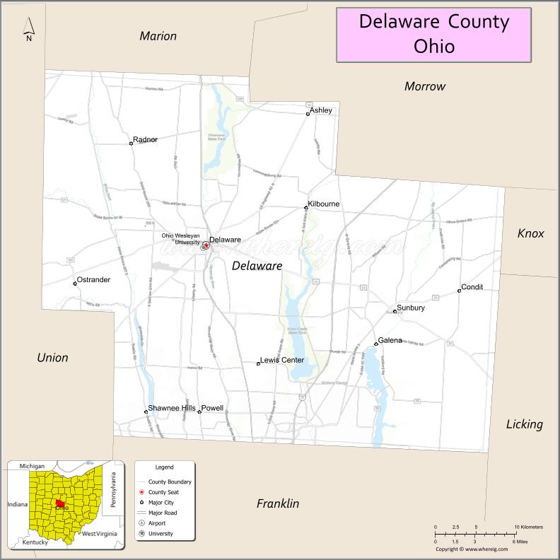
About Delaware County Map, Ohio: The map showing the county boundary, county seat, major cities, highways, water bodies and neighbouring counties.
Ohio More Maps & Info
About Delaware County, Ohio
Delaware County is a county located in the U.S. state of Ohio. It's county seat is Delaware. As per 2020 census, the population of Delaware County is 220740 people and population density is square miles. According to the United States Census Bureau, the county has a total area of 442.41 sq mi (1,146 km2). Delaware County was established on -33510.
Delaware County Facts
| Continent | North America |
| Country | United States |
| State | Ohio |
| County Seat | Delaware |
| Largest City/Town | Delaware |
| Established | February 10, 1808 |
| Total Area | 457 sq mi (1,184 sq km) |
| Land Area | 443 sq mi (1,147 sq km) |
| Water Area | 14 sq mi (36 sq km) |
| Population | 214,124 (Census 2020) |
| Population Density | 483 people per sq mi |
| Time Zone | Eastern Time Zone (ET) |
| Major Highways | I-71, US-23, US-36, State Route 37, State Route 61, State Route 521 |
| Neighboring Counties | Morrow County, Knox County, Licking County, Franklin County, Union County, Marion County |
| Famous For | Alum Creek State Park, rapid growth, historic downtown Delaware |
| Top Attractions | Alum Creek State Park, Delaware State Park, Olentangy Caverns, Stratford Ecological Center |
| Official Website | https://co.delaware.oh.us/ |
Cities and Towns in Delaware County, Ohio
- Delaware (county seat) – 41,302 (Census 2020)
- Powell – 13,204 (Census 2020)
- Sunbury – 6,614 (Census 2020)
- Westerville (partly) – 39,190 (Census 2020)
Roads and Highways in Delaware County, Ohio
Delaware County has a well-developed road system that connects it directly to Columbus and other parts of central Ohio.
- I-71 – major north-south interstate connecting Columbus to Cleveland through the county
- US-23 – runs north-south linking Delaware to Columbus and northern Ohio
- US-36 – east-west route connecting Delaware to Newark and Marysville
- State Route 37 – connects Delaware to Granville and other nearby towns
- State Route 61 – north-south route linking Sunbury to Mount Gilead
- State Route 521 – connects Delaware to eastern rural communities
Neighboring Counties of Delaware County
- Marion County (north)
- Morrow County (northeast)
- Knox County (east)
- Licking County (southeast)
- Franklin County (south)
- Union County (west)
Top Attractions in Delaware County, Ohio
Delaware County offers a mix of outdoor recreation, natural attractions, and family-friendly destinations.
- Alum Creek State Park – large park with boating, beaches, and camping areas
- Delaware State Park – peaceful spot for fishing, hiking, and picnicking
- Olentangy Caverns – unique cave system with tours and outdoor activities
- Stratford Ecological Center – working farm and nature education center
- Historic Downtown Delaware – charming area with shops, dining, and events
- Alum Creek Beach – one of the largest inland beaches in Ohio
- Highbanks Metro Park – scenic park with trails and river overlooks
- Gallant Woods Park – nature preserve with trails and wildlife viewing
Distance from Delaware County to Nearby Cities
- Delaware County to Columbus – 25 mi (40 km)
- Delaware County to Newark – 35 mi (56 km)
- Delaware County to Mansfield – 45 mi (72 km)
- Delaware County to Dayton – 80 mi (129 km)
- Delaware County to Cleveland – 115 mi (185 km)
FAQs about Delaware County
Delaware County is located in central Ohio, just north of Columbus.
It is known for rapid growth, outdoor parks, and a historic downtown area.
The population was 214,124 in the 2020 Census.
Delaware is the largest city and also the county seat.
Yes, the county offers parks, lakes, trails, and nature centers.
- Adams County Map
- Allen County Map
- Ashland County Map
- Ashtabula County Map
- Athens County Map
- Auglaize County Map
- Belmont County Map
- Brown County Map
- Butler County Map
- Carroll County Map
- Champaign County Map
- Clark County Map
- Clermont County Map
- Clinton County Map
- Columbiana County Map
- Coshocton County Map
- Crawford County Map
- Cuyahoga County Map
- Darke County Map
- Defiance County Map
- Delaware County Map
- Erie County Map
- Fairfield County Map
- Fayette County Map
- Franklin County Map
- Fulton County Map
- Gallia County Map
- Geauga County Map
- Greene County Map
- Guernsey County Map
- Hamilton County Map
- Hancock County Map
- Hardin County Map
- Harrison County Map
- Henry County Map
- Highland County Map
- Hocking County Map
- Holmes County Map
- Huron County Map
- Jackson County Map
- Jefferson County Map
- Knox County Map
- Lake County Map
- Lawrence County Map
- Licking County Map
- Logan County Map
- Lorain County Map
- Lucas County Map
- Madison County Map
- Mahoning County Map
- Marion County Map
- Medina County Map
- Meigs County Map
- Mercer County Map
- Miami County Map
- Monroe County Map
- Montgomery County Map
- Morgan County Map
- Morrow County Map
- Muskingum County Map
- Noble County Map
- Ottawa County Map
- Paulding County Map
- Perry County Map
- Pickaway County Map
- Pike County Map
- Portage County Map
- Preble County Map
- Putnam County Map
- Richland County Map
- Ross County Map
- Sandusky County Map
- Scioto County Map
- Seneca County Map
- Shelby County Map
- Stark County Map
- Summit County Map
- Trumbull County Map
- Tuscarawas County Map
- Union County Map
- Van Wert County Map
- Vinton County Map
- Warren County Map
- Washington County Map
- Wayne County Map
- Williams County Map
- Wood County Map
- Wyandot County Map
- Alabama Counties
- Alaska boroughs
- Arizona Counties
- Arkansas Counties
- California County Map
- Colorado Counties
- Connecticut Counties
- Delaware Counties
- Florida County Map
- Georgia County Map
- Hawaii Counties
- Idaho Counties
- Illinois Counties
- Indiana Counties
- Iowa Counties
- Kansas Counties
- Kentucky Counties
- Louisiana Counties
- Maine Counties
- Maryland Counties
- Massachusetts Counties
- Michigan County Map
- Minnesota Counties
- Mississippi Counties
- Missouri Counties
- Montana Counties
- Nebraska Counties
- Nevada Counties
- New York Counties
- New Hampshire Counties
- New Jersey Counties
- New Mexico Counties
- North Carolina Counties
- North Dakota Counties
- Ohio County Map
- Oklahoma Counties
- Oregon Counties
- Pennsylvania Counties
- Rhode Island Counties
- South Carolina Counties
- South Dakota Counties
- Map of Tennessee
- Texas County Map
- Utah Counties
- Vermont Counties
- Virginia Counties
- Washington Counties
- West Virginia Counties
- Wisconsin Counties
- Wyoming Counties