Map of Lucas County - Lucas County is a county located in the U.S. state of Ohio. Lucas County Map showing cities, highways, important places and water bodies. Get Where is Lucas County located in the map, major cities in Lucas county, population, areas, and places of interest.
Map of Lucas County, Ohio
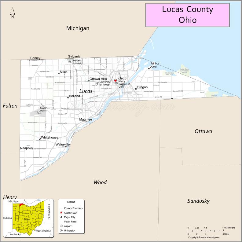
About Lucas County Map, Ohio: The map showing the county boundary, county seat, major cities, highways, water bodies and neighbouring counties.
Ohio More Maps & Info
About Lucas County, Ohio
Lucas County is a county located in the U.S. state of Ohio. It's county seat is Toledo. As per 2020 census, the population of Lucas County is 429191 people and population density is square miles. According to the United States Census Bureau, the county has a total area of 340.46 sq mi (882 km2). Lucas County was established on -23569.
Lucas County Facts
| Continent | North America |
| Country | United States |
| State | Ohio |
| County Seat | Toledo |
| Largest City/Town | Toledo |
| Established | June 20, 1835 |
| Total Area | 596 sq mi (1,543 sq km) |
| Land Area | 341 sq mi (883 sq km) |
| Water Area | 255 sq mi (660 sq km) |
| Population | 431,279 (Census 2020) |
| Population Density | 1,264 people per sq mi |
| Time Zone | Eastern Time Zone (ET) |
| Major Highways | I-75, I-80/I-90 (Ohio Turnpike), I-280, I-475, US-23, US-24 |
| Neighboring Counties | Monroe County (MI), Lenawee County (MI), Fulton County, Wood County, Ottawa County |
| Famous For | Toledo, Lake Erie, glass industry, port and manufacturing |
| Top Attractions | Toledo Zoo, Toledo Museum of Art, Maumee Bay State Park, National Museum of the Great Lakes |
| Official Website | https://co.lucas.oh.us/ |
Cities and Towns in Lucas County, Ohio
- Toledo (county seat) – 270,871 (Census 2020)
- Oregon – 20,291 (Census 2020)
- Sylvania – 19,011 (Census 2020)
- Maumee – 14,424 (Census 2020)
Roads and Highways in Lucas County, Ohio
Lucas County is a major transportation hub in northwest Ohio with extensive highway connections.
- I-75 – major north-south interstate connecting Toledo to Detroit and Cincinnati
- I-80/I-90 (Ohio Turnpike) – major east-west toll road across northern Ohio
- I-280 – connects Toledo to southeastern suburbs and Lake Erie shoreline
- I-475 – bypass loop around Toledo connecting suburbs
- US-23 – north-south route linking Toledo to Columbus and Michigan
- US-24 – connects Toledo to Fort Wayne and western Ohio
Neighboring Counties of Lucas County
- Monroe County, Michigan (north)
- Lenawee County, Michigan (northwest)
- Fulton County (west)
- Wood County (south)
- Ottawa County (east)
Top Attractions in Lucas County, Ohio
Lucas County offers major cultural institutions, parks, and attractions along Lake Erie and the Maumee River.
- Toledo Zoo – one of the top zoos in the United States
- Toledo Museum of Art – renowned museum with extensive collections
- Maumee Bay State Park – popular for beaches, camping, and birdwatching
- National Museum of the Great Lakes – highlights maritime history
- Fifth Third Field – home of the Toledo Mud Hens baseball team
- Toledo Botanical Garden – peaceful garden with walking paths
- Wildwood Preserve Metropark – large park with trails and historic manor
- Imagination Station – hands-on science museum for all ages
Distance from Lucas County to Nearby Cities
- Lucas County to Detroit – 60 mi (97 km)
- Lucas County to Cleveland – 115 mi (185 km)
- Lucas County to Columbus – 140 mi (225 km)
- Lucas County to Fort Wayne – 95 mi (153 km)
- Lucas County to Chicago – 240 mi (386 km)
FAQs about Lucas County
Lucas County is located in northwestern Ohio along Lake Erie.
It is known for Toledo, its port, glass industry, and cultural attractions.
The population was 431,279 according to the 2020 Census.
The county seat is Toledo.
Yes, the county offers zoos, museums, parks, and waterfront attractions.
- Adams County Map
- Allen County Map
- Ashland County Map
- Ashtabula County Map
- Athens County Map
- Auglaize County Map
- Belmont County Map
- Brown County Map
- Butler County Map
- Carroll County Map
- Champaign County Map
- Clark County Map
- Clermont County Map
- Clinton County Map
- Columbiana County Map
- Coshocton County Map
- Crawford County Map
- Cuyahoga County Map
- Darke County Map
- Defiance County Map
- Delaware County Map
- Erie County Map
- Fairfield County Map
- Fayette County Map
- Franklin County Map
- Fulton County Map
- Gallia County Map
- Geauga County Map
- Greene County Map
- Guernsey County Map
- Hamilton County Map
- Hancock County Map
- Hardin County Map
- Harrison County Map
- Henry County Map
- Highland County Map
- Hocking County Map
- Holmes County Map
- Huron County Map
- Jackson County Map
- Jefferson County Map
- Knox County Map
- Lake County Map
- Lawrence County Map
- Licking County Map
- Logan County Map
- Lorain County Map
- Lucas County Map
- Madison County Map
- Mahoning County Map
- Marion County Map
- Medina County Map
- Meigs County Map
- Mercer County Map
- Miami County Map
- Monroe County Map
- Montgomery County Map
- Morgan County Map
- Morrow County Map
- Muskingum County Map
- Noble County Map
- Ottawa County Map
- Paulding County Map
- Perry County Map
- Pickaway County Map
- Pike County Map
- Portage County Map
- Preble County Map
- Putnam County Map
- Richland County Map
- Ross County Map
- Sandusky County Map
- Scioto County Map
- Seneca County Map
- Shelby County Map
- Stark County Map
- Summit County Map
- Trumbull County Map
- Tuscarawas County Map
- Union County Map
- Van Wert County Map
- Vinton County Map
- Warren County Map
- Washington County Map
- Wayne County Map
- Williams County Map
- Wood County Map
- Wyandot County Map
- Alabama Counties
- Alaska boroughs
- Arizona Counties
- Arkansas Counties
- California County Map
- Colorado Counties
- Connecticut Counties
- Delaware Counties
- Florida County Map
- Georgia County Map
- Hawaii Counties
- Idaho Counties
- Illinois Counties
- Indiana Counties
- Iowa Counties
- Kansas Counties
- Kentucky Counties
- Louisiana Counties
- Maine Counties
- Maryland Counties
- Massachusetts Counties
- Michigan County Map
- Minnesota Counties
- Mississippi Counties
- Missouri Counties
- Montana Counties
- Nebraska Counties
- Nevada Counties
- New York Counties
- New Hampshire Counties
- New Jersey Counties
- New Mexico Counties
- North Carolina Counties
- North Dakota Counties
- Ohio County Map
- Oklahoma Counties
- Oregon Counties
- Pennsylvania Counties
- Rhode Island Counties
- South Carolina Counties
- South Dakota Counties
- Map of Tennessee
- Texas County Map
- Utah Counties
- Vermont Counties
- Virginia Counties
- Washington Counties
- West Virginia Counties
- Wisconsin Counties
- Wyoming Counties