Map of Wyandot County - Wyandot County is a county located in the U.S. state of Ohio. Wyandot County Map showing cities, highways, important places and water bodies. Get Where is Wyandot County located in the map, major cities in Wyandot county, population, areas, and places of interest.
Map of Wyandot County, Ohio
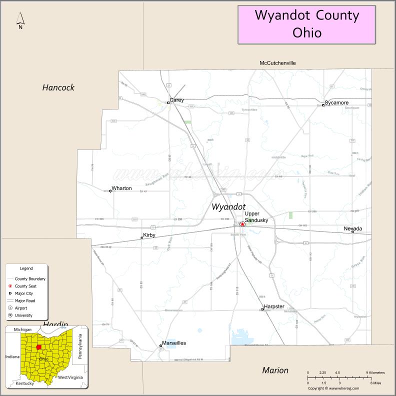
About Wyandot County Map, Ohio: The map showing the county boundary, county seat, major cities, highways, water bodies and neighbouring counties.
Ohio More Maps & Info
About Wyandot County, Ohio
Wyandot County is a county located in the U.S. state of Ohio. It's county seat is Upper Sandusky. As per 2020 census, the population of Wyandot County is 21708 people and population density is square miles. According to the United States Census Bureau, the county has a total area of 405.61 sq mi (1,051 km2). Wyandot County was established on -20053.
Wyandot County Facts
| Continent | North America |
| Country | United States |
| State | Ohio |
| County Seat | Upper Sandusky |
| Largest City/Town | Upper Sandusky |
| Established | February 3, 1845 |
| Total Area | 407 sq mi (1,054 sq km) |
| Land Area | 406 sq mi (1,052 sq km) |
| Water Area | 1.2 sq mi (3.1 sq km) |
| Population | 21,900 (Census 2020) |
| Population Density | 54 people per sq mi |
| Time Zone | Eastern Time Zone (ET) |
| Major Highways | US-23, US-30, State Route 53, State Route 67, State Route 199 |
| Neighboring Counties | Hancock County, Hardin County, Marion County, Crawford County, Seneca County, Wood County |
| Famous For | Rural farmland, Native American history, quiet countryside |
| Top Attractions | Indian Mill Museum, Harrison Smith Park, Upper Sandusky Historic District, Wyandot County Museum |
| Official Website | https://wyandotcountyohio.gov/ |
Cities and Towns in Wyandot County, Ohio
- Upper Sandusky (county seat) – 6,698 (Census 2020)
- Sycamore – 800 (approx.)
- Carey (partly in county) – 3,565 (Census 2020, shared)
- Wharton – small unincorporated community
Roads and Highways in Wyandot County, Ohio
Wyandot County is served by major highways connecting northwest and north-central Ohio.
- US-23 – major north-south route connecting Toledo to Columbus
- US-30 – east-west highway crossing northern Ohio
- State Route 53 – connects the county to Tiffin and Lake Erie region
- State Route 67 – runs through rural parts of the county
- State Route 199 – links Upper Sandusky to surrounding communities
Neighboring Counties of Wyandot County
- Hancock County (north)
- Seneca County (northeast)
- Wood County (northwest)
- Hardin County (west)
- Marion County (south)
- Crawford County (east)
Top Attractions in Wyandot County, Ohio
Wyandot County offers historic sites, museums, and peaceful rural landscapes.
- Indian Mill Museum – historic water-powered mill and local history exhibits
- Wyandot County Museum – preserves regional heritage and artifacts
- Harrison Smith Park – community park with recreation areas
- Upper Sandusky Historic District – downtown area with historic architecture
- Big Darby Plains area nearby – natural scenery and wildlife
- Local Amish countryside – rural farms and scenic drives
- Marion and Tiffin nearby attractions – regional access to larger cities
- Sandusky River nearby – fishing and outdoor recreation
Distance from Wyandot County to Nearby Cities
- Wyandot County to Toledo – 80 mi (129 km)
- Wyandot County to Columbus – 75 mi (121 km)
- Wyandot County to Cleveland – 110 mi (177 km)
- Wyandot County to Findlay – 25 mi (40 km)
- Wyandot County to Marion – 20 mi (32 km)
FAQs about Wyandot County
Wyandot County is located in north-central Ohio.
It is known for its rural farmland, Native American history, and quiet countryside.
The population was about 21,900 according to the 2020 Census.
The county seat is Upper Sandusky.
Yes, Wyandot County offers museums, historic districts, parks, and rural scenic areas.
- Adams County Map
- Allen County Map
- Ashland County Map
- Ashtabula County Map
- Athens County Map
- Auglaize County Map
- Belmont County Map
- Brown County Map
- Butler County Map
- Carroll County Map
- Champaign County Map
- Clark County Map
- Clermont County Map
- Clinton County Map
- Columbiana County Map
- Coshocton County Map
- Crawford County Map
- Cuyahoga County Map
- Darke County Map
- Defiance County Map
- Delaware County Map
- Erie County Map
- Fairfield County Map
- Fayette County Map
- Franklin County Map
- Fulton County Map
- Gallia County Map
- Geauga County Map
- Greene County Map
- Guernsey County Map
- Hamilton County Map
- Hancock County Map
- Hardin County Map
- Harrison County Map
- Henry County Map
- Highland County Map
- Hocking County Map
- Holmes County Map
- Huron County Map
- Jackson County Map
- Jefferson County Map
- Knox County Map
- Lake County Map
- Lawrence County Map
- Licking County Map
- Logan County Map
- Lorain County Map
- Lucas County Map
- Madison County Map
- Mahoning County Map
- Marion County Map
- Medina County Map
- Meigs County Map
- Mercer County Map
- Miami County Map
- Monroe County Map
- Montgomery County Map
- Morgan County Map
- Morrow County Map
- Muskingum County Map
- Noble County Map
- Ottawa County Map
- Paulding County Map
- Perry County Map
- Pickaway County Map
- Pike County Map
- Portage County Map
- Preble County Map
- Putnam County Map
- Richland County Map
- Ross County Map
- Sandusky County Map
- Scioto County Map
- Seneca County Map
- Shelby County Map
- Stark County Map
- Summit County Map
- Trumbull County Map
- Tuscarawas County Map
- Union County Map
- Van Wert County Map
- Vinton County Map
- Warren County Map
- Washington County Map
- Wayne County Map
- Williams County Map
- Wood County Map
- Wyandot County Map
- Alabama Counties
- Alaska boroughs
- Arizona Counties
- Arkansas Counties
- California County Map
- Colorado Counties
- Connecticut Counties
- Delaware Counties
- Florida County Map
- Georgia County Map
- Hawaii Counties
- Idaho Counties
- Illinois Counties
- Indiana Counties
- Iowa Counties
- Kansas Counties
- Kentucky Counties
- Louisiana Counties
- Maine Counties
- Maryland Counties
- Massachusetts Counties
- Michigan County Map
- Minnesota Counties
- Mississippi Counties
- Missouri Counties
- Montana Counties
- Nebraska Counties
- Nevada Counties
- New York Counties
- New Hampshire Counties
- New Jersey Counties
- New Mexico Counties
- North Carolina Counties
- North Dakota Counties
- Ohio County Map
- Oklahoma Counties
- Oregon Counties
- Pennsylvania Counties
- Rhode Island Counties
- South Carolina Counties
- South Dakota Counties
- Map of Tennessee
- Texas County Map
- Utah Counties
- Vermont Counties
- Virginia Counties
- Washington Counties
- West Virginia Counties
- Wisconsin Counties
- Wyoming Counties