Map of Gallia County - Gallia County is a county located in the U.S. state of Ohio. Gallia County Map showing cities, highways, important places and water bodies. Get Where is Gallia County located in the map, major cities in Gallia county, population, areas, and places of interest.
Map of Gallia County, Ohio
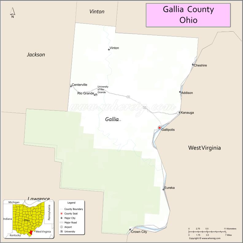
About Gallia County Map, Ohio: The map showing the county boundary, county seat, major cities, highways, water bodies and neighbouring counties.
Ohio More Maps & Info
About Gallia County, Ohio
Gallia County is a county located in the U.S. state of Ohio. It's county seat is Gallipolis. As per 2020 census, the population of Gallia County is 29158 people and population density is square miles. According to the United States Census Bureau, the county has a total area of 468.78 sq mi (1,214 km2). Gallia County was established on -35308.
Gallia County Facts
| Continent | North America |
| Country | United States |
| State | Ohio |
| County Seat | Gallipolis |
| Largest City/Town | Gallipolis |
| Established | April 30, 1803 |
| Total Area | 471 sq mi (1,220 sq km) |
| Land Area | 464 sq mi (1,202 sq km) |
| Water Area | 7.5 sq mi (19.4 sq km) |
| Population | 29,220 (Census 2020) |
| Population Density | 63 people per sq mi |
| Time Zone | Eastern Time Zone (ET) |
| Major Highways | US-35, State Route 7, State Route 141, State Route 160 |
| Neighboring Counties | Meigs County, Jackson County, Lawrence County, Mason County (WV) |
| Famous For | Ohio River views, French heritage, rural Appalachian landscapes |
| Top Attractions | Gallipolis City Park, Tu-Endie-Wei State Park, Rio Grande University, Ohio Riverfront |
| Official Website | https://www.galliacounty.org/ |
Cities and Towns in Gallia County, Ohio
- Gallipolis (county seat) – 3,313 (Census 2020)
- Rio Grande – 915 (Census 2020)
- Bidwell – 2,171 (Census 2020)
- Vinton – 323 (Census 2020)
Roads and Highways in Gallia County, Ohio
Gallia County is served by highways that connect it to southeastern Ohio and neighboring West Virginia.
- US-35 – major east-west route connecting Gallipolis to Jackson and Chillicothe
- State Route 7 – scenic highway running along the Ohio River
- State Route 141 – connects Gallipolis to Jackson County and surrounding areas
- State Route 160 – runs north-south linking rural communities within the county
Neighboring Counties of Gallia County
- Meigs County (north)
- Jackson County (northwest)
- Lawrence County (southwest)
- Mason County, West Virginia (south and east)
Top Attractions in Gallia County, Ohio
Gallia County offers scenic river views, historic parks, and a peaceful Appalachian setting.
- Gallipolis City Park – central park with monuments and river views
- Tu-Endie-Wei State Park – historic park along the Ohio River
- University of Rio Grande – small college with scenic surroundings
- Ohio Riverfront – ideal for walking, relaxing, and enjoying views
- Gallia County Fairgrounds – hosts local events and fairs
- Raccoon Creek region access – nearby outdoor area for hiking and nature
- Bossard Memorial Library – historic local landmark
- French Art Colony – cultural center with art exhibits and events
Distance from Gallia County to Nearby Cities
- Gallia County to Huntington – 35 mi (56 km)
- Gallia County to Charleston – 60 mi (97 km)
- Gallia County to Athens – 45 mi (72 km)
- Gallia County to Columbus – 110 mi (177 km)
- Gallia County to Cincinnati – 140 mi (225 km)
FAQs about Gallia County
Gallia County is located in southeastern Ohio along the Ohio River.
It is known for its French heritage, scenic river views, and Appalachian landscape.
The population was 29,220 according to the 2020 Census.
The county seat is Gallipolis.
Yes, the county offers parks, riverfront views, and nearby hiking areas.
- Adams County Map
- Allen County Map
- Ashland County Map
- Ashtabula County Map
- Athens County Map
- Auglaize County Map
- Belmont County Map
- Brown County Map
- Butler County Map
- Carroll County Map
- Champaign County Map
- Clark County Map
- Clermont County Map
- Clinton County Map
- Columbiana County Map
- Coshocton County Map
- Crawford County Map
- Cuyahoga County Map
- Darke County Map
- Defiance County Map
- Delaware County Map
- Erie County Map
- Fairfield County Map
- Fayette County Map
- Franklin County Map
- Fulton County Map
- Gallia County Map
- Geauga County Map
- Greene County Map
- Guernsey County Map
- Hamilton County Map
- Hancock County Map
- Hardin County Map
- Harrison County Map
- Henry County Map
- Highland County Map
- Hocking County Map
- Holmes County Map
- Huron County Map
- Jackson County Map
- Jefferson County Map
- Knox County Map
- Lake County Map
- Lawrence County Map
- Licking County Map
- Logan County Map
- Lorain County Map
- Lucas County Map
- Madison County Map
- Mahoning County Map
- Marion County Map
- Medina County Map
- Meigs County Map
- Mercer County Map
- Miami County Map
- Monroe County Map
- Montgomery County Map
- Morgan County Map
- Morrow County Map
- Muskingum County Map
- Noble County Map
- Ottawa County Map
- Paulding County Map
- Perry County Map
- Pickaway County Map
- Pike County Map
- Portage County Map
- Preble County Map
- Putnam County Map
- Richland County Map
- Ross County Map
- Sandusky County Map
- Scioto County Map
- Seneca County Map
- Shelby County Map
- Stark County Map
- Summit County Map
- Trumbull County Map
- Tuscarawas County Map
- Union County Map
- Van Wert County Map
- Vinton County Map
- Warren County Map
- Washington County Map
- Wayne County Map
- Williams County Map
- Wood County Map
- Wyandot County Map
- Alabama Counties
- Alaska boroughs
- Arizona Counties
- Arkansas Counties
- California County Map
- Colorado Counties
- Connecticut Counties
- Delaware Counties
- Florida County Map
- Georgia County Map
- Hawaii Counties
- Idaho Counties
- Illinois Counties
- Indiana Counties
- Iowa Counties
- Kansas Counties
- Kentucky Counties
- Louisiana Counties
- Maine Counties
- Maryland Counties
- Massachusetts Counties
- Michigan County Map
- Minnesota Counties
- Mississippi Counties
- Missouri Counties
- Montana Counties
- Nebraska Counties
- Nevada Counties
- New York Counties
- New Hampshire Counties
- New Jersey Counties
- New Mexico Counties
- North Carolina Counties
- North Dakota Counties
- Ohio County Map
- Oklahoma Counties
- Oregon Counties
- Pennsylvania Counties
- Rhode Island Counties
- South Carolina Counties
- South Dakota Counties
- Map of Tennessee
- Texas County Map
- Utah Counties
- Vermont Counties
- Virginia Counties
- Washington Counties
- West Virginia Counties
- Wisconsin Counties
- Wyoming Counties