Map of Greene County - Greene County is a county located in the U.S. state of Ohio. Greene County Map showing cities, highways, important places and water bodies. Get Where is Greene County located in the map, major cities in Greene county, population, areas, and places of interest.
Map of Greene County, Ohio
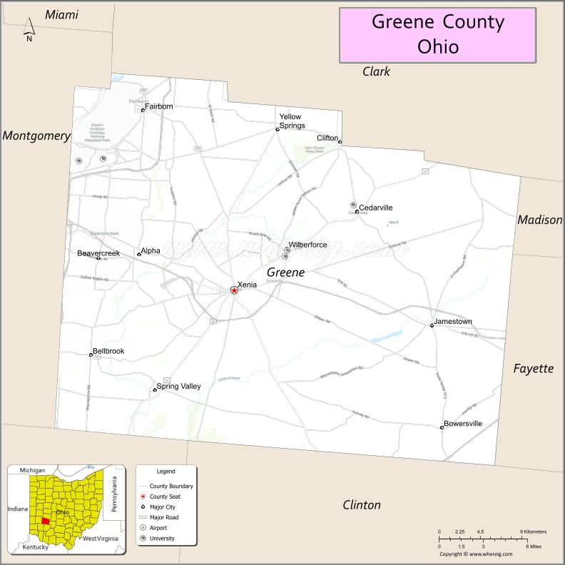
About Greene County Map, Ohio: The map showing the county boundary, county seat, major cities, highways, water bodies and neighbouring counties.
Ohio More Maps & Info
About Greene County, Ohio
Greene County is a county located in the U.S. state of Ohio. It's county seat is Xenia. As per 2020 census, the population of Greene County is 168412 people and population density is square miles. According to the United States Census Bureau, the county has a total area of 414.88 sq mi (1,075 km2). Greene County was established on -35307.
Greene County Facts
| Continent | North America |
| Country | United States |
| State | Ohio |
| County Seat | Xenia |
| Largest City/Town | Beavercreek |
| Established | March 24, 1803 |
| Total Area | 416 sq mi (1,077 sq km) |
| Land Area | 414 sq mi (1,072 sq km) |
| Water Area | 1.9 sq mi (4.9 sq km) |
| Population | 168,937 (Census 2020) |
| Population Density | 408 people per sq mi |
| Time Zone | Eastern Time Zone (ET) |
| Major Highways | I-675, US-35, US-42, State Route 4, State Route 68, State Route 72 |
| Neighboring Counties | Clark County, Madison County, Fayette County, Clinton County, Warren County, Montgomery County |
| Famous For | Wright-Patterson Air Force Base, bike trails, Xenia Tornado history |
| Top Attractions | John Bryan State Park, Clifton Gorge, National Museum of the U.S. Air Force, Greene Trails |
| Official Website | https://www.greenecountyohio.gov/ |
Cities and Towns in Greene County, Ohio
- Xenia (county seat) – 25,719 (Census 2020)
- Beavercreek – 46,549 (Census 2020)
- Fairborn – 34,510 (Census 2020)
- Yellow Springs – 3,697 (Census 2020)
Roads and Highways in Greene County, Ohio
Greene County is well connected with major highways that link it to Dayton and other parts of southwestern Ohio.
- I-675 – bypass route connecting Dayton suburbs including Beavercreek and Fairborn
- US-35 – major east-west highway connecting Dayton to Chillicothe
- US-42 – runs north-south linking Xenia to Cincinnati and Columbus
- State Route 4 – connects the county to Dayton and Springfield
- State Route 68 – runs north-south through Xenia and Yellow Springs
- State Route 72 – links Cedarville to Springfield and surrounding areas
Neighboring Counties of Greene County
- Clark County (north)
- Madison County (northeast)
- Fayette County (east)
- Clinton County (south)
- Warren County (southwest)
- Montgomery County (west)
Top Attractions in Greene County, Ohio
Greene County offers a mix of natural beauty, aviation history, and outdoor recreation.
- John Bryan State Park – scenic park with cliffs, trails, and river views
- Clifton Gorge State Nature Preserve – dramatic gorge with hiking paths
- National Museum of the U.S. Air Force – one of the largest aviation museums in the world
- Yellow Springs – vibrant village known for arts, shops, and culture
- Greene County Trails – extensive network of bike and walking trails
- Caesar Creek State Park – nearby park with lake activities and camping
- Historic Xenia – downtown area with local shops and history
- Wright-Patterson Air Force Base area – key military and aviation site
Distance from Greene County to Nearby Cities
- Greene County to Dayton – 10 mi (16 km)
- Greene County to Columbus – 70 mi (113 km)
- Greene County to Cincinnati – 55 mi (89 km)
- Greene County to Springfield – 25 mi (40 km)
- Greene County to Chillicothe – 65 mi (105 km)
FAQs about Greene County
Greene County is located in southwestern Ohio near Dayton.
It is known for Wright-Patterson Air Force Base, bike trails, and natural parks.
The population was 168,937 according to the 2020 Census.
Beavercreek is the largest city, while Xenia is the county seat.
Yes, the county has parks, trails, and scenic areas like John Bryan State Park and Clifton Gorge.
- Adams County Map
- Allen County Map
- Ashland County Map
- Ashtabula County Map
- Athens County Map
- Auglaize County Map
- Belmont County Map
- Brown County Map
- Butler County Map
- Carroll County Map
- Champaign County Map
- Clark County Map
- Clermont County Map
- Clinton County Map
- Columbiana County Map
- Coshocton County Map
- Crawford County Map
- Cuyahoga County Map
- Darke County Map
- Defiance County Map
- Delaware County Map
- Erie County Map
- Fairfield County Map
- Fayette County Map
- Franklin County Map
- Fulton County Map
- Gallia County Map
- Geauga County Map
- Greene County Map
- Guernsey County Map
- Hamilton County Map
- Hancock County Map
- Hardin County Map
- Harrison County Map
- Henry County Map
- Highland County Map
- Hocking County Map
- Holmes County Map
- Huron County Map
- Jackson County Map
- Jefferson County Map
- Knox County Map
- Lake County Map
- Lawrence County Map
- Licking County Map
- Logan County Map
- Lorain County Map
- Lucas County Map
- Madison County Map
- Mahoning County Map
- Marion County Map
- Medina County Map
- Meigs County Map
- Mercer County Map
- Miami County Map
- Monroe County Map
- Montgomery County Map
- Morgan County Map
- Morrow County Map
- Muskingum County Map
- Noble County Map
- Ottawa County Map
- Paulding County Map
- Perry County Map
- Pickaway County Map
- Pike County Map
- Portage County Map
- Preble County Map
- Putnam County Map
- Richland County Map
- Ross County Map
- Sandusky County Map
- Scioto County Map
- Seneca County Map
- Shelby County Map
- Stark County Map
- Summit County Map
- Trumbull County Map
- Tuscarawas County Map
- Union County Map
- Van Wert County Map
- Vinton County Map
- Warren County Map
- Washington County Map
- Wayne County Map
- Williams County Map
- Wood County Map
- Wyandot County Map
- Alabama Counties
- Alaska boroughs
- Arizona Counties
- Arkansas Counties
- California County Map
- Colorado Counties
- Connecticut Counties
- Delaware Counties
- Florida County Map
- Georgia County Map
- Hawaii Counties
- Idaho Counties
- Illinois Counties
- Indiana Counties
- Iowa Counties
- Kansas Counties
- Kentucky Counties
- Louisiana Counties
- Maine Counties
- Maryland Counties
- Massachusetts Counties
- Michigan County Map
- Minnesota Counties
- Mississippi Counties
- Missouri Counties
- Montana Counties
- Nebraska Counties
- Nevada Counties
- New York Counties
- New Hampshire Counties
- New Jersey Counties
- New Mexico Counties
- North Carolina Counties
- North Dakota Counties
- Ohio County Map
- Oklahoma Counties
- Oregon Counties
- Pennsylvania Counties
- Rhode Island Counties
- South Carolina Counties
- South Dakota Counties
- Map of Tennessee
- Texas County Map
- Utah Counties
- Vermont Counties
- Virginia Counties
- Washington Counties
- West Virginia Counties
- Wisconsin Counties
- Wyoming Counties