Map of Ottawa County - Ottawa County is a county located in the U.S. state of Ohio. Ottawa County Map showing cities, highways, important places and water bodies. Get Where is Ottawa County located in the map, major cities in Ottawa county, population, areas, and places of interest.
Map of Ottawa County, Ohio
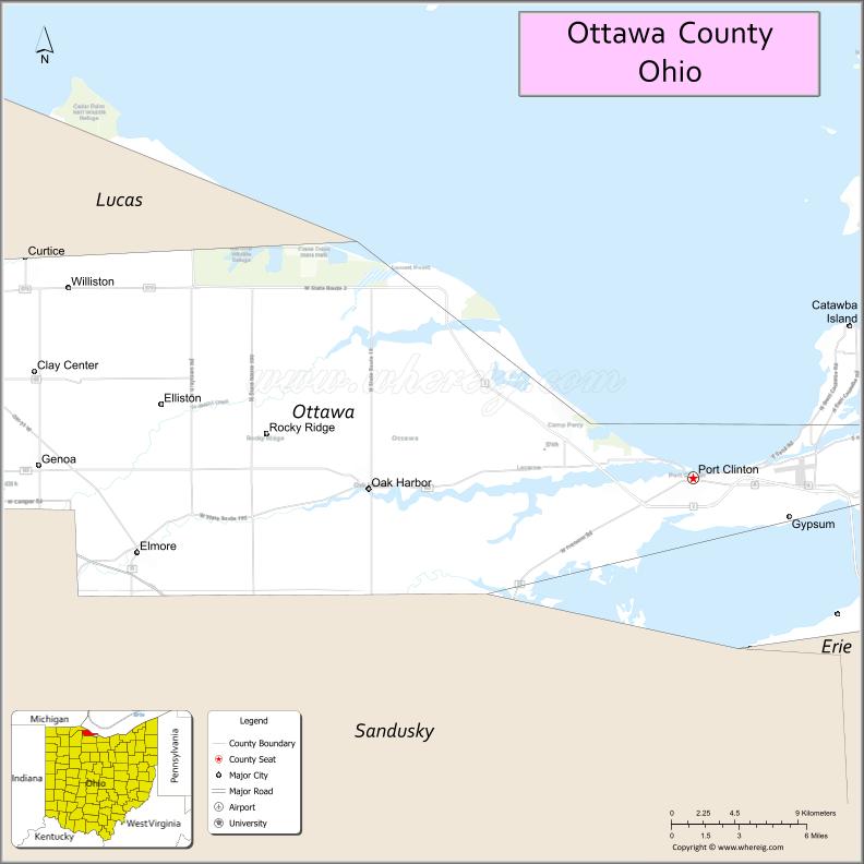
About Ottawa County Map, Ohio: The map showing the county boundary, county seat, major cities, highways, water bodies and neighbouring counties.
Ohio More Maps & Info
About Ottawa County, Ohio
Ottawa County is a county located in the U.S. state of Ohio. It's county seat is Port Clinton. As per 2020 census, the population of Ottawa County is 40104 people and population density is square miles. According to the United States Census Bureau, the county has a total area of 254.95 sq mi (660 km2). Ottawa County was established on -21848.
Ottawa County Facts
| Continent | North America |
| Country | United States |
| State | Ohio |
| County Seat | Port Clinton |
| Largest City/Town | Port Clinton |
| Established | March 6, 1840 |
| Total Area | 584 sq mi (1,512 sq km) |
| Land Area | 255 sq mi (661 sq km) |
| Water Area | 329 sq mi (852 sq km) |
| Population | 40,364 (Census 2020) |
| Population Density | 158 people per sq mi |
| Time Zone | Eastern Time Zone (ET) |
| Major Highways | State Route 2, State Route 53, State Route 163, State Route 19, State Route 269 |
| Neighboring Counties | Lucas County, Sandusky County, Erie County |
| Famous For | Lake Erie islands, fishing, tourism, Marblehead Lighthouse |
| Top Attractions | Put-in-Bay, Kelleys Island, Marblehead Lighthouse, Cedar Point nearby |
| Official Website | https://www.co.ottawa.oh.us/ |
Cities and Towns in Ottawa County, Ohio
- Port Clinton (county seat) – 6,056 (Census 2020)
- Oak Harbor – 2,728 (Census 2020)
- Genoa – 2,289 (Census 2020)
- Marblehead – 903 (Census 2020)
Roads and Highways in Ottawa County, Ohio
Ottawa County is connected by highways that run along Lake Erie and provide access to coastal communities and islands.
- State Route 2 – major east-west route along Lake Erie connecting Toledo to Sandusky
- State Route 53 – connects Port Clinton to Fremont and inland areas
- State Route 163 – links Oak Harbor to Port Clinton and the lakefront
- State Route 19 – runs north-south connecting the county to Fremont
- State Route 269 – provides access to Marblehead Peninsula and ferry terminals
Neighboring Counties of Ottawa County
- Lucas County (west)
- Sandusky County (south)
- Erie County (east)
Top Attractions in Ottawa County, Ohio
Ottawa County is a popular destination for lakeside recreation, island tourism, and outdoor activities.
- Put-in-Bay – lively island destination known for entertainment and waterfront views
- Kelleys Island – peaceful island with natural attractions and glacial grooves
- Marblehead Lighthouse – one of the oldest lighthouses on the Great Lakes
- East Harbor State Park – offers camping, beaches, and boating
- Port Clinton Waterfront – scenic area with restaurants and marinas
- African Safari Wildlife Park – drive-through safari park near Port Clinton
- Ottawa National Wildlife Refuge – great for birdwatching and nature trails
- Catawba Island area – popular for boating, wineries, and scenic views
Distance from Ottawa County to Nearby Cities
- Ottawa County to Toledo – 35 mi (56 km)
- Ottawa County to Sandusky – 20 mi (32 km)
- Ottawa County to Cleveland – 70 mi (113 km)
- Ottawa County to Detroit – 80 mi (129 km)
- Ottawa County to Columbus – 120 mi (193 km)
FAQs about Ottawa County
Ottawa County is located in northern Ohio along the southern shore of Lake Erie.
It is known for Lake Erie islands, fishing, tourism, and historic lighthouses.
The population was 40,364 according to the 2020 Census.
The county seat is Port Clinton.
Yes, the county offers islands, parks, beaches, and outdoor recreation.
- Adams County Map
- Allen County Map
- Ashland County Map
- Ashtabula County Map
- Athens County Map
- Auglaize County Map
- Belmont County Map
- Brown County Map
- Butler County Map
- Carroll County Map
- Champaign County Map
- Clark County Map
- Clermont County Map
- Clinton County Map
- Columbiana County Map
- Coshocton County Map
- Crawford County Map
- Cuyahoga County Map
- Darke County Map
- Defiance County Map
- Delaware County Map
- Erie County Map
- Fairfield County Map
- Fayette County Map
- Franklin County Map
- Fulton County Map
- Gallia County Map
- Geauga County Map
- Greene County Map
- Guernsey County Map
- Hamilton County Map
- Hancock County Map
- Hardin County Map
- Harrison County Map
- Henry County Map
- Highland County Map
- Hocking County Map
- Holmes County Map
- Huron County Map
- Jackson County Map
- Jefferson County Map
- Knox County Map
- Lake County Map
- Lawrence County Map
- Licking County Map
- Logan County Map
- Lorain County Map
- Lucas County Map
- Madison County Map
- Mahoning County Map
- Marion County Map
- Medina County Map
- Meigs County Map
- Mercer County Map
- Miami County Map
- Monroe County Map
- Montgomery County Map
- Morgan County Map
- Morrow County Map
- Muskingum County Map
- Noble County Map
- Ottawa County Map
- Paulding County Map
- Perry County Map
- Pickaway County Map
- Pike County Map
- Portage County Map
- Preble County Map
- Putnam County Map
- Richland County Map
- Ross County Map
- Sandusky County Map
- Scioto County Map
- Seneca County Map
- Shelby County Map
- Stark County Map
- Summit County Map
- Trumbull County Map
- Tuscarawas County Map
- Union County Map
- Van Wert County Map
- Vinton County Map
- Warren County Map
- Washington County Map
- Wayne County Map
- Williams County Map
- Wood County Map
- Wyandot County Map
- Alabama Counties
- Alaska boroughs
- Arizona Counties
- Arkansas Counties
- California County Map
- Colorado Counties
- Connecticut Counties
- Delaware Counties
- Florida County Map
- Georgia County Map
- Hawaii Counties
- Idaho Counties
- Illinois Counties
- Indiana Counties
- Iowa Counties
- Kansas Counties
- Kentucky Counties
- Louisiana Counties
- Maine Counties
- Maryland Counties
- Massachusetts Counties
- Michigan County Map
- Minnesota Counties
- Mississippi Counties
- Missouri Counties
- Montana Counties
- Nebraska Counties
- Nevada Counties
- New York Counties
- New Hampshire Counties
- New Jersey Counties
- New Mexico Counties
- North Carolina Counties
- North Dakota Counties
- Ohio County Map
- Oklahoma Counties
- Oregon Counties
- Pennsylvania Counties
- Rhode Island Counties
- South Carolina Counties
- South Dakota Counties
- Map of Tennessee
- Texas County Map
- Utah Counties
- Vermont Counties
- Virginia Counties
- Washington Counties
- West Virginia Counties
- Wisconsin Counties
- Wyoming Counties