Map of Allen County - Allen County is a county located in the U.S. state of Ohio. Allen County Map showing cities, highways, important places and water bodies. Get Where is Allen County located in the map, major cities in Allen county, population, areas, and places of interest.
Map of Allen County, Ohio
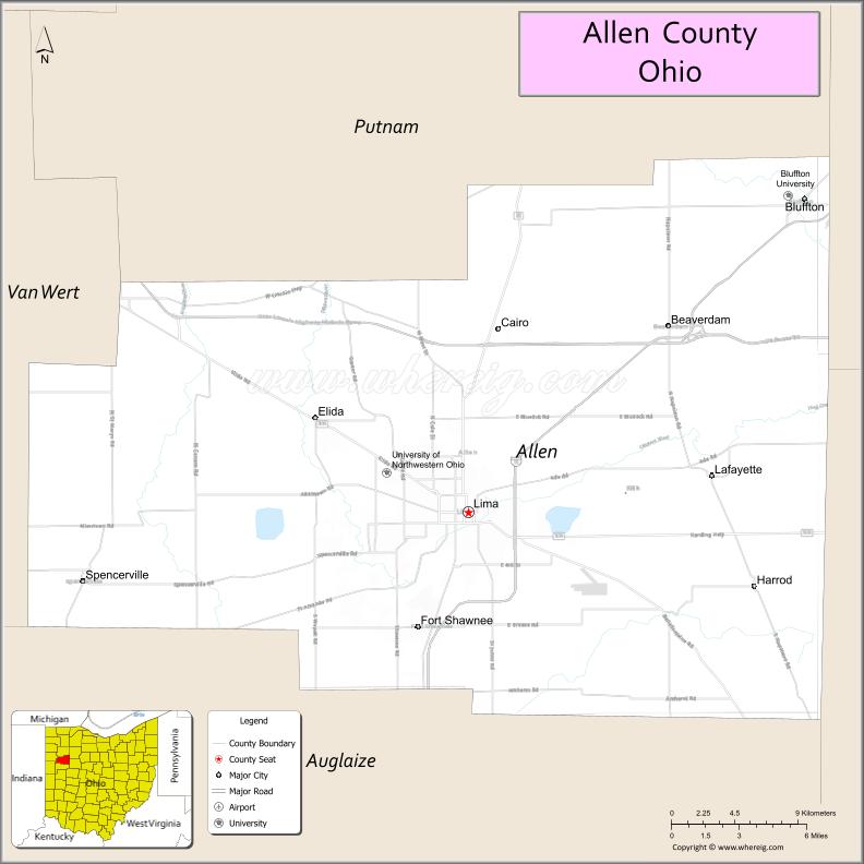
About Allen County Map, Ohio: The map showing the county boundary, county seat, major cities, highways, water bodies and neighbouring counties.
Ohio More Maps & Info
About Allen County, Ohio
Allen County is a county located in the U.S. state of Ohio. It's county seat is Lima. As per 2020 census, the population of Allen County is 101670 people and population density is square miles. According to the United States Census Bureau, the county has a total area of 404.43 sq mi (1,047 km2). Allen County was established on -29158.
Allen County Facts
| Continent | North America |
| Country | United States |
| State | Ohio |
| County Seat | Lima |
| Largest City/Town | Lima |
| Established | 1831 |
| Total Area | 407 sq mi |
| Land Area | 402 sq mi |
| Water Area | 5 sq mi |
| Population | 102,351 (Census 2020) |
| Population Density | 254 people per sq mi |
| Time Zone | Eastern (EST) |
| Major Highways | I-75, US-30, US-224, SR-117 |
| Neighboring Counties | Auglaize County, Hardin County, Putnam County, Hancock County, Van Wert County |
| Famous For | Lima petroleum history, manufacturing, agriculture |
| Top Attractions | Allen County Museum, Veterans Memorial Civic Center, Faurot Park |
| Official Website | https://www.allencountyohio.com |
Cities and Towns in Allen County, Ohio
- Lima (county seat) – 35,579 (Census 2020)
- Delphos – 6,698 (Census 2020)
- Spencerville – 2,261 (Census 2020)
- Lafayette – 406 (Census 2020)
Roads and Highways in Allen County, Ohio
Allen County is a transportation hub in northwest Ohio with major highways connecting it to regional cities and interstate routes.
- Interstate 75 (I-75) – Major north-south corridor connecting Lima to Toledo and Cincinnati
- U.S. Route 30 (US-30) – East-west route linking the county to Fort Wayne and Mansfield
- U.S. Route 224 (US-224) – Connects local communities across northwest Ohio
- State Route 117 (SR-117) – Links Lima with surrounding rural areas
Neighboring Counties of Allen County
- Auglaize County (east)
- Hardin County (southeast)
- Putnam County (north)
- Hancock County (northeast)
- Van Wert County (west)
Top Attractions in Allen County, Ohio
Allen County offers museums, parks, and cultural attractions centered around Lima.
- Allen County Museum – Local history museum with exhibits and artifacts
- Veterans Memorial Civic Center – Event venue for concerts and performances
- Faurot Park – Large city park with trails and recreation areas
- Lincoln Park Railway Exhibit – Historic railroad display
- Lima Stadium – Sports and community events venue
- Shawnee Country Club – Golf and recreational facility
- Johnny Appleseed Park (nearby region influence) – Popular outdoor space
Distance from Allen County to Nearby Cities
- Lima to Columbus – 80 mi (129 km)
- Lima to Toledo – 100 mi (161 km)
- Lima to Dayton – 75 mi (121 km)
- Lima to Fort Wayne, IN – 75 mi (121 km)
- Lima to Cincinnati – 130 mi (209 km)
FAQs about Allen County
Allen County is known for Lima’s industrial history, manufacturing, and agriculture.
Lima is the county seat of Allen County.
Yes, Allen County is located in northwest Ohio.
Visitors enjoy museums, parks, civic centers, and local history sites.
Interstate 75 runs through Allen County connecting it to major Ohio cities.
- Adams County Map
- Allen County Map
- Ashland County Map
- Ashtabula County Map
- Athens County Map
- Auglaize County Map
- Belmont County Map
- Brown County Map
- Butler County Map
- Carroll County Map
- Champaign County Map
- Clark County Map
- Clermont County Map
- Clinton County Map
- Columbiana County Map
- Coshocton County Map
- Crawford County Map
- Cuyahoga County Map
- Darke County Map
- Defiance County Map
- Delaware County Map
- Erie County Map
- Fairfield County Map
- Fayette County Map
- Franklin County Map
- Fulton County Map
- Gallia County Map
- Geauga County Map
- Greene County Map
- Guernsey County Map
- Hamilton County Map
- Hancock County Map
- Hardin County Map
- Harrison County Map
- Henry County Map
- Highland County Map
- Hocking County Map
- Holmes County Map
- Huron County Map
- Jackson County Map
- Jefferson County Map
- Knox County Map
- Lake County Map
- Lawrence County Map
- Licking County Map
- Logan County Map
- Lorain County Map
- Lucas County Map
- Madison County Map
- Mahoning County Map
- Marion County Map
- Medina County Map
- Meigs County Map
- Mercer County Map
- Miami County Map
- Monroe County Map
- Montgomery County Map
- Morgan County Map
- Morrow County Map
- Muskingum County Map
- Noble County Map
- Ottawa County Map
- Paulding County Map
- Perry County Map
- Pickaway County Map
- Pike County Map
- Portage County Map
- Preble County Map
- Putnam County Map
- Richland County Map
- Ross County Map
- Sandusky County Map
- Scioto County Map
- Seneca County Map
- Shelby County Map
- Stark County Map
- Summit County Map
- Trumbull County Map
- Tuscarawas County Map
- Union County Map
- Van Wert County Map
- Vinton County Map
- Warren County Map
- Washington County Map
- Wayne County Map
- Williams County Map
- Wood County Map
- Wyandot County Map
- Alabama Counties
- Alaska boroughs
- Arizona Counties
- Arkansas Counties
- California County Map
- Colorado Counties
- Connecticut Counties
- Delaware Counties
- Florida County Map
- Georgia County Map
- Hawaii Counties
- Idaho Counties
- Illinois Counties
- Indiana Counties
- Iowa Counties
- Kansas Counties
- Kentucky Counties
- Louisiana Counties
- Maine Counties
- Maryland Counties
- Massachusetts Counties
- Michigan County Map
- Minnesota Counties
- Mississippi Counties
- Missouri Counties
- Montana Counties
- Nebraska Counties
- Nevada Counties
- New York Counties
- New Hampshire Counties
- New Jersey Counties
- New Mexico Counties
- North Carolina Counties
- North Dakota Counties
- Ohio County Map
- Oklahoma Counties
- Oregon Counties
- Pennsylvania Counties
- Rhode Island Counties
- South Carolina Counties
- South Dakota Counties
- Map of Tennessee
- Texas County Map
- Utah Counties
- Vermont Counties
- Virginia Counties
- Washington Counties
- West Virginia Counties
- Wisconsin Counties
- Wyoming Counties