Map of Summit County - Summit County is a county located in the U.S. state of Ohio. Summit County Map showing cities, highways, important places and water bodies. Get Where is Summit County located in the map, major cities in Summit county, population, areas, and places of interest.
Map of Summit County, Ohio
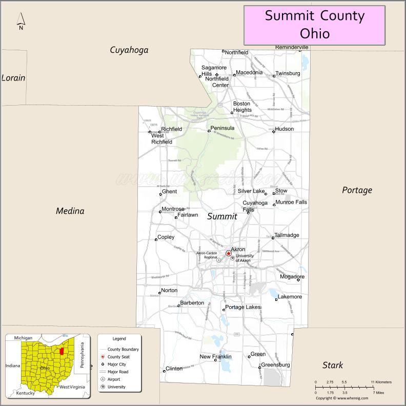
About Summit County Map, Ohio: The map showing the county boundary, county seat, major cities, highways, water bodies and neighbouring counties.
Ohio More Maps & Info
About Summit County, Ohio
Summit County is a county located in the U.S. state of Ohio. It's county seat is Akron. As per 2020 census, the population of Summit County is 537633 people and population density is square miles. According to the United States Census Bureau, the county has a total area of 419.38 sq mi (1,086 km2). Summit County was established on -21851.
Summit County Facts
| Continent | North America |
| Country | United States |
| State | Ohio |
| County Seat | Akron |
| Largest City/Town | Akron |
| Established | March 3, 1840 |
| Total Area | 419 sq mi (1,085 sq km) |
| Land Area | 412 sq mi (1,067 sq km) |
| Water Area | 7.3 sq mi (18.9 sq km) |
| Population | 540,428 (Census 2020) |
| Population Density | 1,312 people per sq mi |
| Time Zone | Eastern Time Zone (ET) |
| Major Highways | I-77, I-76, I-271, State Route 8, US-224 |
| Neighboring Counties | Cuyahoga County, Geauga County, Portage County, Stark County, Wayne County, Medina County |
| Famous For | Akron Rubber Industry, Cuyahoga Valley National Park, education |
| Top Attractions | Cuyahoga Valley National Park, Akron Zoo, Stan Hywet Hall & Gardens, Akron Art Museum |
| Official Website | https://www.summitoh.net/ |
Cities and Towns in Summit County, Ohio
- Akron (county seat) – 190,469 (Census 2020)
- Cuyahoga Falls – 51,114 (Census 2020)
- Stow – 34,483 (Census 2020)
- Tallmadge – 17,537 (Census 2020)
Roads and Highways in Summit County, Ohio
Summit County is a major transportation hub in northeastern Ohio with extensive highway connections.
- I-77 – major north-south interstate connecting Cleveland to Canton
- I-76 – east-west route linking Akron to Youngstown and Wooster
- I-271 – connects Summit County to suburban Cleveland areas
- State Route 8 – key north-south highway through Akron
- US-224 – connects Akron to surrounding communities and highways
Neighboring Counties of Summit County
- Cuyahoga County (north)
- Geauga County (northeast)
- Portage County (east)
- Stark County (south)
- Wayne County (southwest)
- Medina County (west)
Top Attractions in Summit County, Ohio
Summit County offers cultural attractions, parks, and outdoor recreation.
- Cuyahoga Valley National Park – scenic park with trails, waterfalls, and wildlife
- Stan Hywet Hall & Gardens – historic estate with gardens and tours
- Akron Zoo – family-friendly zoo with a variety of animals
- Akron Art Museum – modern and contemporary art exhibits
- Hale Farm & Village – living history museum showcasing 19th-century life
- Summit Metro Parks – network of parks and trails throughout the county
- Blossom Music Center – outdoor concert venue
- Lock 3 Park – downtown Akron park hosting events and festivals
Distance from Summit County to Nearby Cities
- Summit County to Cleveland – 35 mi (56 km)
- Summit County to Canton – 25 mi (40 km)
- Summit County to Youngstown – 55 mi (89 km)
- Summit County to Columbus – 125 mi (201 km)
- Summit County to Pittsburgh – 115 mi (185 km)
FAQs about Summit County
Summit County is located in northeastern Ohio.
It is known for Akron’s rubber industry and Cuyahoga Valley National Park.
The population was 540,428 according to the 2020 Census.
The county seat is Akron.
Yes, the county offers parks, museums, and cultural attractions.
- Adams County Map
- Allen County Map
- Ashland County Map
- Ashtabula County Map
- Athens County Map
- Auglaize County Map
- Belmont County Map
- Brown County Map
- Butler County Map
- Carroll County Map
- Champaign County Map
- Clark County Map
- Clermont County Map
- Clinton County Map
- Columbiana County Map
- Coshocton County Map
- Crawford County Map
- Cuyahoga County Map
- Darke County Map
- Defiance County Map
- Delaware County Map
- Erie County Map
- Fairfield County Map
- Fayette County Map
- Franklin County Map
- Fulton County Map
- Gallia County Map
- Geauga County Map
- Greene County Map
- Guernsey County Map
- Hamilton County Map
- Hancock County Map
- Hardin County Map
- Harrison County Map
- Henry County Map
- Highland County Map
- Hocking County Map
- Holmes County Map
- Huron County Map
- Jackson County Map
- Jefferson County Map
- Knox County Map
- Lake County Map
- Lawrence County Map
- Licking County Map
- Logan County Map
- Lorain County Map
- Lucas County Map
- Madison County Map
- Mahoning County Map
- Marion County Map
- Medina County Map
- Meigs County Map
- Mercer County Map
- Miami County Map
- Monroe County Map
- Montgomery County Map
- Morgan County Map
- Morrow County Map
- Muskingum County Map
- Noble County Map
- Ottawa County Map
- Paulding County Map
- Perry County Map
- Pickaway County Map
- Pike County Map
- Portage County Map
- Preble County Map
- Putnam County Map
- Richland County Map
- Ross County Map
- Sandusky County Map
- Scioto County Map
- Seneca County Map
- Shelby County Map
- Stark County Map
- Summit County Map
- Trumbull County Map
- Tuscarawas County Map
- Union County Map
- Van Wert County Map
- Vinton County Map
- Warren County Map
- Washington County Map
- Wayne County Map
- Williams County Map
- Wood County Map
- Wyandot County Map
- Alabama Counties
- Alaska boroughs
- Arizona Counties
- Arkansas Counties
- California County Map
- Colorado Counties
- Connecticut Counties
- Delaware Counties
- Florida County Map
- Georgia County Map
- Hawaii Counties
- Idaho Counties
- Illinois Counties
- Indiana Counties
- Iowa Counties
- Kansas Counties
- Kentucky Counties
- Louisiana Counties
- Maine Counties
- Maryland Counties
- Massachusetts Counties
- Michigan County Map
- Minnesota Counties
- Mississippi Counties
- Missouri Counties
- Montana Counties
- Nebraska Counties
- Nevada Counties
- New York Counties
- New Hampshire Counties
- New Jersey Counties
- New Mexico Counties
- North Carolina Counties
- North Dakota Counties
- Ohio County Map
- Oklahoma Counties
- Oregon Counties
- Pennsylvania Counties
- Rhode Island Counties
- South Carolina Counties
- South Dakota Counties
- Map of Tennessee
- Texas County Map
- Utah Counties
- Vermont Counties
- Virginia Counties
- Washington Counties
- West Virginia Counties
- Wisconsin Counties
- Wyoming Counties