
Where is Ewa Beach Located? - Ewa Beach is a city located in the Honolulu County of Hawaii, United States. Ewa Beach lies between 42.0883603 Degrees North latitudes and 87.9806265 Degrees West longitudes.
Location Map of Ewa Beach, Hawaii
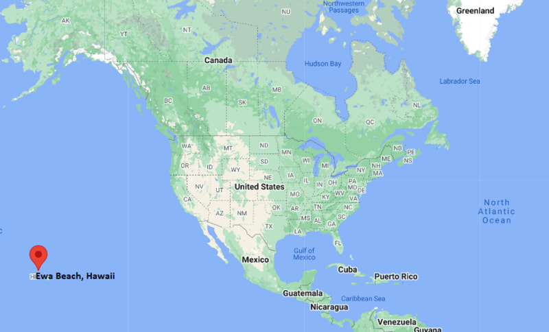
Ewa Beach Map, Hawaii, USA
Where is Ewa Beach?: The Google Map showing the location of Ewa Beach in the U.S. state of Hawaii.
Where is Ewa Beach Located?
Ewa Beach is a city located in the Honolulu County of Hawaii, United States. Ewa Beach lies between 42.0883603 Degrees North latitudes and 87.9806265 Degrees West longitudes. According to 2020 U.S.census, the population of Ewa Beach city is 16415 people and the city has a total area of 1.19 sq mi. The city has numerous parks and recreational facilities.
Most Viewed US Maps
| USA Sttae Map | USA Region Map | USA Road Map |
| USA County Map | Where is USA in World Map? | US ZIP Code Map |
| USA Time Zones Map | US State and Capitals Map | USA Physical Map |
Find 4,400+ U.S. Cities by State - Explore Their Locations and Get Detailed Information
Ewa Beach, Hawaii Quick Facts
| Property | Details |
|---|---|
| Community | Ewa Beach (CDP) |
| County | Honolulu County |
| State | Hawaii |
| State Capital | Honolulu |
| US Region | West |
| Latitude | 21.3156°N |
| Longitude | 158.0072°W |
| Elevation | ~10 ft (3 m) |
| Land Area | Approx. 4.9 sq mi |
| Water Area | Approx. 0.1 sq mi |
| Total Area | Approx. 5.0 sq mi |
| Population (2020 Census) | ~16,000 |
| Population Density | Approximately 3,000+ per sq mi |
| ZIP Codes | 96706 |
| Area Code | 808 |
| Time Zone Standard | Hawaii-Aleutian Standard Time (HST), UTC−10 |
| Time Zone Daylight | Not observed (no DST) |
| Currency | US Dollar (USD) |
| FIPS Code | 15-07000 (Honolulu County area) |
| Congressional District | Hawaii 1st Congressional District |
Nearby Cities to Ewa Beach, Hawaii
- Kapolei, Hawaii - Northwest - 5 mi
- Waipahu, Hawaii - Northeast - 6 mi
- Pearl City, Hawaii - Northeast - 10 mi
- Mililani, Hawaii - North - 15 mi
- Aiea, Hawaii - Northeast - 12 mi
- Honolulu, Hawaii - East - 18 mi
- Waianae, Hawaii - Northwest - 20 mi
- Hickam Housing, Hawaii - East - 14 mi
- Makakilo, Hawaii - North - 7 mi
- Wahiawa, Hawaii - North - 18 mi
Ewa Beach, Hawaii Climate and Weather Overview
| Month | Avg High (°F) | Avg Low (°F) | Avg Rainfall (in) |
|---|---|---|---|
| January | 80 | 65 | 2.1 |
| April | 82 | 68 | 0.9 |
| July | 88 | 73 | 0.5 |
| October | 86 | 71 | 1.3 |
| Annual | 84 | 69 | ~17.0 |
| Climate Attribute | Details |
|---|---|
| Climate Classification (Köppen) | Tropical savanna (Aw) |
| Annual Rainfall | About 15–20 inches |
| Summer Conditions | Hot, humid, and mostly dry |
| Winter Conditions | Mild and warm with trade winds |
| Severe Weather Risk | Occasional tropical storms, coastal flooding risk |
Driving Distances from Ewa Beach, Hawaii
| City | Island/State | Distance (mi) | Approx. Drive Time |
|---|---|---|---|
| Kapolei | Hawaii | 5 | 10–15 min |
| Waipahu | Hawaii | 6 | 15 min |
| Pearl City | Hawaii | 10 | 20–25 min |
| Aiea | Hawaii | 12 | 25 min |
| Honolulu | Hawaii | 18 | 30–45 min |
| Mililani | Hawaii | 15 | 25–30 min |
| Wahiawa | Hawaii | 18 | 30 min |
| Waianae | Hawaii | 20 | 35–40 min |
| Haleiwa | Hawaii | 30 | 50–60 min |
| Kailua | Hawaii | 25 | 45–55 min |
Transportation and Connectivity in Ewa Beach, Hawaii
| Transportation | Details |
|---|---|
| Airport Name | Daniel K. Inouye International Airport |
| IATA Code | HNL |
| Major Highways | H-1 Freeway, H-2 (access via interchange), Fort Weaver Road |
| Public Transit | TheBus (Oahu public bus system) |
| Rail Service | Honolulu Skyline Rail (partial service on Oahu) |
| Port Access | Honolulu Harbor (regional) |
- Ewa Beach is part of the rapidly growing Ewa Plain suburban region on Oahu.
- The area has expanded significantly due to planned residential development.
- It is a major commuter community for Honolulu and Kapolei.
- Proximity to beaches and resorts makes it both residential and tourism-adjacent.
Places to Visit in Ewa Beach, Hawaii
| Landmark Name | Type |
|---|---|
| Ewa Beach Park | Beach Park |
| Puʻuloa Beach Park | Coastal Park |
| Barbers Point Beach Park | Beach Park |
| Ka Makana Ali‘i (nearby Kapolei) | Shopping Mall |
| Hawaiian Railway Society | Historic Railway |
| Wet'n'Wild Hawaii (nearby) | Water Park |
| Ko Olina Lagoons | Resort Beach Area |
| Paradise Cove Luau | Cultural Attraction |
| White Plains Beach | Surf Beach |
| Honouliuli National Historic Site (nearby) | Historic Site |
Colleges and Universities in Ewa Beach, Hawaii
| Institution Name | Type | Level | Notable For |
|---|---|---|---|
| University of Hawaii – West Oahu | Public | University | Business, public administration, liberal arts |
| University of Hawaii at Manoa (regional access) | Public | University | Research, medicine, engineering |
| Hawaii Pacific University | Private | University | Business, nursing, marine science |
| Kapi‘olani Community College (regional access) | Public | Community College | Healthcare and technical training |
| Leeward Community College | Public | Community College | Career and transfer programs |
| Kapolei Charter Schools | Public | K–12 | Local education system |
| James Campbell High School | Public | High School | Large West Oahu public school |
| Oahu Educational Programs Network | Public | Education System | Island-wide academic support programs |
Waterbodies in Ewa Beach, Hawaii
Pacific Ocean, Pearl Harbor (nearby), Puʻuloa Lagoon, Barbers Point Harbor, West Loch of Pearl Harbor, Kalaeloa shoreline waters, Ewa Coastal Wetlands, Kapolei coastal inlets
Golf Courses in Ewa Beach, Hawaii
Hawaii Prince Golf Club, Coral Creek Golf Course, Hoakalei Country Club, Kapolei Golf Club, Ewa Beach Golf Club (area courses), Ko Olina Golf Club, Royal Kunia Country Club (nearby), Waikele Golf Club
Ewa Beach, Hawaii — Key Historical Facts
- Ewa Beach developed on former sugar plantation lands of the Ewa Plantation Company.
- The name “Ewa” is derived from a Hawaiian word meaning “stray” or “lost,” tied to local legends.
- The area was historically dominated by agriculture, especially sugarcane production.
- After plantation decline, the region transitioned into suburban residential development.
- Military presence nearby (Pearl Harbor and Barbers Point) influenced local growth.
- Today, Ewa Beach is one of Oahu’s fastest-growing residential communities.
References
Hawaii Related Maps and Info
- Where is East Honolulu
- Where is Waipahu
- Where is Pearl City
- Where is Hilo
- Where is Kailua
- Where is Kaneohe
- Where is Kahului
- Where is Mililani Town
- Where is Ewa Gentry
- Where is Kapolei
- Where is Kailua
- Where is Kihei
- Where is Mililani Mauka
- Where is Makakilo
- Where is Wahiawa
- Where is Wailuku
- Where is Ocean Pointe
- Where is Ewa Beach
- Where is Hawaiian Paradise Park
- Where is Halawa
- Where is Royal Kunia
- Where is Schofield Barracks
- Where is Waimalu
- Where is Waianae
- Where is Lahaina
- Where is Waipio
- Where is Maili
- Where is Nanakuli
- Where is Kapaa
- Where is Aiea
- Where is Makaha
- Where is Waimea
- Where is Waihee-Waiehu
- Where is Ahuimanu
- Where is Haiku-Pauwela
- Where is Pukalani
- Where is Lihue
- Where is Ewa Villages
- Where is Hickam Housing
- Where is Waikele
- Where is Makawao
- Where is Waikoloa Village
- Where is Kula
- Where is Napili-Honokowai
- Where is Waimanalo
- Where is Wailua Homesteads
- Where is Wailea
- Where is Laie
- Where is Waipio Acres