
Where is Waipio Located? - Waipio is a city located in the Honolulu County of Hawaii, United States. Waipio lies between 42.0664167 Degrees North latitudes and 87.9372908 Degrees West longitudes.
Location Map of Waipio, Hawaii
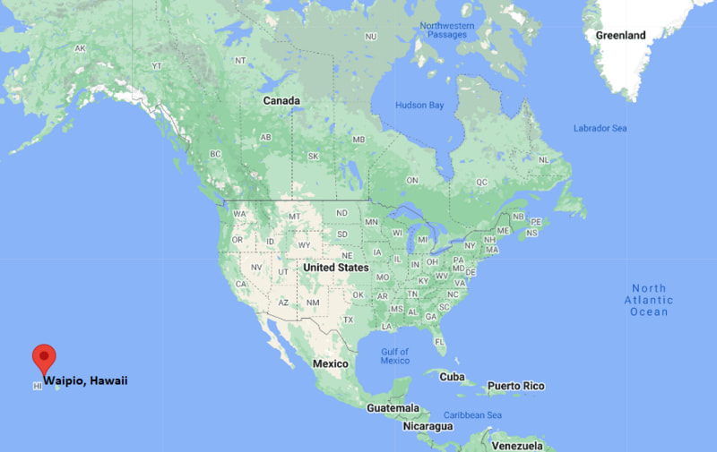
Waipio Map, Hawaii, USA
Where is Waipio?: The Google Map showing the location of Waipio in the U.S. state of Hawaii.
Where is Waipio Located?
Waipio is a city located in the Honolulu County of Hawaii, United States. Waipio lies between 42.0664167 Degrees North latitudes and 87.9372908 Degrees West longitudes. According to 2020 U.S.census, the population of Waipio city is 12082 people and the city has a total area of 1.25 sq mi. The city has numerous parks and recreational facilities.
Most Viewed US Maps
| USA Sttae Map | USA Region Map | USA Road Map |
| USA County Map | Where is USA in World Map? | US ZIP Code Map |
| USA Time Zones Map | US State and Capitals Map | USA Physical Map |
Find 4,400+ U.S. Cities by State - Explore Their Locations and Get Detailed Information
Waipio, Hawaii Quick Facts
| Attribute | Details |
|---|---|
| City | Waipio |
| County | Honolulu County |
| State | Hawaii |
| State Capital | Honolulu |
| US Region | Pacific Region |
| Island | Oahu |
| Latitude | 21.4180° N |
| Longitude | 157.9994° W |
| Elevation | Approximately 100 ft (30 m) |
| Land Area | 2.4 sq mi |
| Water Area | 0.0 sq mi |
| Total Area | 2.4 sq mi |
| Population (2020 Census) | 11,674 |
| Population Density | Approximately 4,860 per sq mi |
| ZIP Code | 96797 |
| Area Code | 808 |
| Time Zone Standard | Hawaii-Aleutian Standard Time (HST), UTC−10 |
| Time Zone Daylight | Hawaii does not observe Daylight Saving Time |
| Currency | United States Dollar (USD) |
| FIPS Code | 15-79700 |
| Community Type | Census-designated place (CDP) |
Transportation and Connectivity in Waipio, Hawaii
| Transportation | Details |
|---|---|
| Nearest Airport | Daniel K. Inouye International Airport (Honolulu) |
| IATA Code | HNL |
| Regional Airport | Daniel K. Inouye International Airport |
| Major Highways | Interstate H-1, Interstate H-2, Kamehameha Highway |
| Bus Service | TheBus provides public transportation throughout Oahu |
| Rail Service | Honolulu Skyline rail system serves nearby West Oahu communities |
| Local Connectivity | Central Oahu location with access to Mililani, Pearl City, Waipahu, and Honolulu |
- Interstate H-1 — Main freeway connecting Waipio with Honolulu, Pearl City, and West Oahu.
- Interstate H-2 — Provides access to Wahiawa, Mililani, and northern Oahu communities.
- Kamehameha Highway — Regional route connecting Central Oahu neighborhoods.
Top Places to Visit in Waipio, Hawaii
| Landmark Name | Type |
|---|---|
| Waikele Premium Outlets | Shopping Center |
| Hawaii's Plantation Village | Cultural Museum |
| Waipahu Cultural Garden Park | Cultural Park |
| Central Oahu Regional Park | Recreation Area |
| Pearl Harbor National Memorial | Historic Site |
| Wet'n'Wild Hawaii | Water Park |
| Waikele Golf Club | Golf Course |
| Pearl Ridge Center | Shopping Center |
| West Loch Shoreline Park | Waterfront Park |
| Dole Plantation | Agricultural Attraction |
Driving Distances from Waipio, Hawaii to Nearby Cities and Places
| City / Place | State | Distance (mi) | Approx. Drive Time |
|---|---|---|---|
| Waipahu | Hawaii | 5 mi | 10 minutes |
| Mililani | Hawaii | 5 mi | 10 minutes |
| Wahiawa | Hawaii | 10 mi | 20 minutes |
| Pearl City | Hawaii | 8 mi | 15 minutes |
| Honolulu | Hawaii | 18 mi | 30 minutes |
| Daniel K. Inouye International Airport | Hawaii | 15 mi | 25 minutes |
| Kapolei | Hawaii | 18 mi | 30 minutes |
| Haleiwa | Hawaii | 25 mi | 40 minutes |
| Kailua | Hawaii | 35 mi | 55 minutes |
| Waianae | Hawaii | 45 mi | 1 hour |
Colleges and Universities Near Waipio, Hawaii
| Institution Name | Type | Level | Notable For |
|---|---|---|---|
| Leeward Community College | Public | Community College | Associate degrees, liberal arts, technology, and workforce programs |
| University of Hawaii - West Oahu | Public | University | Business, education, public administration, and applied sciences |
| University of Hawaii at Manoa | Public | University | Research, ocean sciences, education, business, and Pacific studies |
| Honolulu Community College | Public | Community College | Technical education, trades, transportation, and applied programs |
| Hawaii Pacific University | Private | University | Business, health sciences, international studies, and liberal arts |
Waterbodies Near Waipio, Hawaii
Waikele Stream, Kipapa Stream, Pearl Harbor waters, West Loch, and nearby Central Oahu waterways provide opportunities for nature viewing, fishing, walking trails, and outdoor recreation.
Golf Courses and Stadiums Near Waipio
Golf Courses: Waikele Golf Club, Mililani Golf Club, Royal Kunia Country Club, and Pearl Country Club. Stadiums and sports facilities include Waipio Peninsula Soccer Complex, Waipahu High School athletic facilities, Central Oahu Regional Park, and nearby community recreation centers.
Key Landmarks and Places to Visit in Waipio, Hawaii
| Landmark Name | Type |
|---|---|
| Hawaii's Plantation Village | Cultural Museum |
| Waipahu Cultural Garden Park | Cultural Park |
| Waipio Peninsula Soccer Complex | Sports Facility |
| Central Oahu Regional Park | Recreation Area |
| Pearl Harbor National Memorial | Historic Site |
| Waikele Premium Outlets | Shopping Center |
| Wet'n'Wild Hawaii | Water Park |
| Waikele Golf Club | Golf Course |
| West Loch Shoreline Park | Waterfront Park |
| Dole Plantation | Agricultural Attraction |
Waipio, Hawaii — Key Historical Facts
- The Waipio area is located in Central Oahu and has a long Native Hawaiian history connected to fertile agricultural lands and freshwater streams.
- The name Waipio is derived from Hawaiian words associated with water and valleys, reflecting the importance of natural resources in the region.
- Ancient Hawaiian communities used the surrounding lands for farming, including taro cultivation and other traditional crops.
- The Central Oahu plains became important agricultural areas during the plantation era, especially for sugar and pineapple production.
- The nearby Waipahu and Waikele areas developed as plantation communities with workers arriving from many countries and cultures.
- Transportation improvements and the growth of Honolulu’s metropolitan area transformed Waipio into a suburban community.
- The development of parks, sports facilities, and residential neighborhoods increased Waipio’s importance as a Central Oahu community.
- Today, Waipio is known for its residential neighborhoods, sports facilities, nearby shopping areas, agricultural heritage, and convenient access to Honolulu and West Oahu.
References
- United States Census Bureau
- City and County of Honolulu Official Website
- State of Hawaii Official Website
- Hawaii's Plantation Village
- Hawaii Tourism Authority
Hawaii Related Maps and Info
- Where is East Honolulu
- Where is Waipahu
- Where is Pearl City
- Where is Hilo
- Where is Kailua
- Where is Kaneohe
- Where is Kahului
- Where is Mililani Town
- Where is Ewa Gentry
- Where is Kapolei
- Where is Kailua
- Where is Kihei
- Where is Mililani Mauka
- Where is Makakilo
- Where is Wahiawa
- Where is Wailuku
- Where is Ocean Pointe
- Where is Ewa Beach
- Where is Hawaiian Paradise Park
- Where is Halawa
- Where is Royal Kunia
- Where is Schofield Barracks
- Where is Waimalu
- Where is Waianae
- Where is Lahaina
- Where is Waipio
- Where is Maili
- Where is Nanakuli
- Where is Kapaa
- Where is Aiea
- Where is Makaha
- Where is Waimea
- Where is Waihee-Waiehu
- Where is Ahuimanu
- Where is Haiku-Pauwela
- Where is Pukalani
- Where is Lihue
- Where is Ewa Villages
- Where is Hickam Housing
- Where is Waikele
- Where is Makawao
- Where is Waikoloa Village
- Where is Kula
- Where is Napili-Honokowai
- Where is Waimanalo
- Where is Wailua Homesteads
- Where is Wailea
- Where is Laie
- Where is Waipio Acres