
Fort Walton Beach is a coastal city in northwest Florida and part of the Fort Walton Beach–Crestview–Destin metropolitan area. It is about 45 miles east of Pensacola on the Gulf Coast. The city is known for its white-sand beaches, emerald-green waters, Gulfarium Marine Adventure Park, and easy access to Okaloosa Island and Destin.
Location Map of Fort Walton Beach, Okaloosa County, Florida
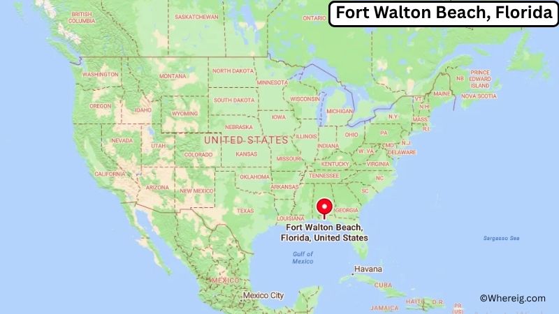
About Map: The map shows the location of Fort Walton Beach in Okaloosa County, in the U.S. state of Florida.
Fort Walton Beach Map, Florida
About Fort Walton Beach Map: The Google Map highlights the location of Fort Walton Beach in Okaloosa County, Florida. Use the zoom, satellite, and street-view options to explore the city's neighborhoods, roads, and nearby places.
Where is Fort Walton Beach Located?
Fort Walton Beach is a city located in Okaloosa County, Florida, the United States. It lies on Florida's Emerald Coast between Pensacola and Panama City, about 45 miles east of Pensacola, 8 miles west of Destin, and roughly 40 miles south of Crestview. Fort Walton Beach is positioned at approximately 30.405° North latitude and 86.618° West longitude. The city covers about 8.16 square miles, or 21.13 square kilometers, including land and water. The 2020 Census recorded 20,922 residents, while recent estimates place the population at about 21,000. The city has a low coastal elevation, with most developed areas close to sea level. Fort Walton Beach developed around Choctawhatchee Bay and the Gulf of Mexico, with tourism, military activity, fishing, and coastal recreation shaping its modern character. Okaloosa Island, connected to the mainland by bridges, provides access to broad Gulf beaches and the Gulfarium Marine Adventure Park. The city is also near Eglin Air Force Base, one of the largest military installations in the United States. U.S. Highway 98 and State Road 85 provide important connections to Destin, Niceville, Crestview, and Pensacola.
Most Viewed US Maps
| USA Sttae Map | USA Region Map | USA Road Map |
| USA County Map | Where is USA in World Map? | US ZIP Code Map |
| USA Time Zones Map | US State and Capitals Map | USA Physical Map |
Find 4,400+ U.S. Cities by State - Explore Their Locations and Get Detailed Information
Fort Walton Beach City Facts
| City | Fort Walton Beach |
|---|---|
| State | Florida |
| County | Okaloosa County |
| Country | United States |
| Region | Northwest Florida, Emerald Coast |
| Incorporated | June 16, 1941 |
| Founded | 1930s |
| Total Area | 8.16 sq mi (21.13 sq km) |
| Land Area | 7.48 sq mi (19.37 sq km) |
| Water Area | 0.68 sq mi (1.76 sq km) |
| Elevation | 10 ft (3 m) |
| Population (2023 estimate) | About 21,000 |
| Population (2020 Census) | 20,922 |
| Population Density | 2,796.0 people per sq mi |
| Time Zone | Central Time (CST/CDT) |
| ZIP Codes | 32547, 32548 |
| Area Code | 850 |
| Major Highways | U.S. Highway 98, Florida State Road 85, Florida State Road 189 |
| Public Transit | Okaloosa County Transit |
| Major Attractions | Okaloosa Island, Gulfarium Marine Adventure Park, Fort Walton Beach Landing Park, Indian Temple Mound Museum, John Beasley Park |
| Official Website | https://www.fwb.org/ |
Distance from Fort Walton Beach, FL to Nearby Cities
- Mary Esther, FL – 5 miles (8 km)
- Niceville, FL – 8 miles (13 km)
- Destin, FL – 8 miles (13 km)
- Shalimar, FL – 5 miles (8 km)
- Valparaiso, FL – 10 miles (16 km)
- Navarre, FL – 20 miles (32 km)
- Crestview, FL – 40 miles (64 km)
- Miramar Beach, FL – 15 miles (24 km)
- Santa Rosa Beach, FL – 25 miles (40 km)
- Milton, FL – 35 miles (56 km)
- Pensacola, FL – 45 miles (72 km)
- Panama City, FL – 75 miles (121 km)
- DeFuniak Springs, FL – 55 miles (89 km)
- Chipley, FL – 75 miles (121 km)
- Mobile, AL – 100 miles (161 km)
- Tallahassee, FL – 160 miles (257 km)
- Montgomery, AL – 175 miles (282 km)
- Jacksonville, FL – 315 miles (507 km)
Top Attractions in Fort Walton Beach
- Okaloosa Island – A barrier island with wide Gulf beaches, fishing areas, walking paths, restaurants, and waterfront recreation.
- Gulfarium Marine Adventure Park – A long-running marine attraction featuring dolphins, sea lions, tropical birds, reptiles, and other animals.
- Fort Walton Beach Landing Park – A waterfront park along the Choctawhatchee Bay with walking areas, green space, events, and views of the water.
- Indian Temple Mound Museum – A museum preserving Native American artifacts and archaeological history from the Fort Walton culture and the surrounding region.
- John Beasley Park – A beachfront recreation area on Okaloosa Island with Gulf access, picnic facilities, restrooms, and parking.
- Gulf Islands National Seashore – A protected coastal area extending across northwest Florida and Mississippi with beaches, dunes, historic sites, and wildlife habitat.
- Henderson Beach State Park – A scenic Gulf Coast park near Destin featuring white-sand beaches, dunes, nature trails, camping, and wildlife viewing.
- Big Kahuna's Water & Adventure Park – A large water park in nearby Destin with slides, pools, and family attractions.
- Air Force Armament Museum – A museum near Eglin Air Force Base displaying military aircraft, weapons, and aviation history.
- Destin Harbor – A nearby waterfront district known for fishing boats, charter trips, restaurants, and views of the Gulf and harbor.
Airports Near Fort Walton Beach
- Destin-Fort Walton Beach Airport (VPS) – 10 miles
- Destin Executive Airport (DTS) – 15 miles
- Pensacola International Airport (PNS) – 50 miles
- Northwest Florida Beaches International Airport (ECP) – 80 miles
- Mobile Regional Airport (MOB) – 105 miles
Sources:
Population and area data sourced from the United States Census Bureau (2020 Census). General city information referenced from the official City of Fort Walton Beach website and local government records.
Florida Related Maps and Info
- Where is Miami
- Where is Hialeah
- Where is Jacksonville
- Where is Orlando
- Where is Saint Petersburg
- Where is Tampa
- Where is Alafaya
- Where is Boca Raton
- Where is Boynton Beach
- Where is Brandon
- Where is Cape Coral
- Where is Clearwater
- Where is Coral Springs
- Where is Davie
- Where is Daytona Beach
- Where is Deerfield Beach
- Where is Deltona
- Where is Doral
- Where is Fort Lauderdale
- Where is Fort Myers
- Where is Gainesville
- Where is Hollywood
- Where is Homestead
- Where is Horizon West
- Where is Kendall
- Where is Kissimmee
- Where is Lakeland
- Where is Largo
- Where is Lauderhill
- Where is Lehigh Acres
- Where is Melbourne
- Where is Miami Beach
- Where is Miami Gardens
- Where is Miramar
- Where is North Port
- Where is Palm Bay
- Where is Palm Coast
- Where is Pembroke Pines
- Where is Plantation
- Where is Poinciana
- Where is Pompano Beach
- Where is Port St. Lucie
- Where is Riverview
- Where is Spring Hill
- Where is St. Petersburg
- Where is Sunrise
- Where is Tallahassee
- Where is Tamarac
- Where is The Villages
- Where is Town 'n' Country
- Where is West Palm Beach