
Where is Linton Hall Located? - Linton Hall is a city located in the Prince William County of Virginia, United States. Linton Hall lies between 30.0799405 Degrees North latitudes and 95.4171601 Degrees West longitudes.
Location Map of Linton Hall, Virginia
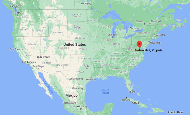
Linton Hall Map, Virginia, USA
Where is Linton Hall?: The Google Map showing the location of Linton Hall in the U.S. state of Virginia.
Where is Linton Hall Located?
Linton Hall is a city located in the Prince William County of Virginia, United States. Linton Hall lies between 30.0799405 Degrees North latitudes and 95.4171601 Degrees West longitudes. According to 2020 U.S.census, the population of Linton Hall city is 41754 people and the city has a total area of 12.73 sq mi. The city has numerous parks and recreational facilities.
Most Viewed US Maps
| USA Sttae Map | USA Region Map | USA Road Map |
| USA County Map | Where is USA in World Map? | US ZIP Code Map |
| USA Time Zones Map | US State and Capitals Map | USA Physical Map |
Find 4,400+ U.S. Cities by State - Explore Their Locations and Get Detailed Information
Linton Hall, Virginia Quick Facts
| Attribute | Details |
|---|---|
| Community | Linton Hall (Census-Designated Place) |
| County | Prince William County |
| State | Virginia |
| State Capital | Richmond |
| US Region | Southern United States (South Atlantic) |
| Latitude | 38.7530° N |
| Longitude | 77.5747° W |
| Elevation | 246 ft (75 m) |
| Land Area | 12.73 sq mi |
| Water Area | 0.00 sq mi |
| Total Area | 12.73 sq mi |
| Population (2020 Census) | 41,754 |
| Population Density | 3,280 per sq mi |
| ZIP Code | 20136 |
| Area Code(s) | 703, 571 |
| Time Zone Standard | Eastern Standard Time (EST, UTC−5) |
| Time Zone Daylight | Eastern Daylight Time (EDT, UTC−4) |
| Currency | United States Dollar (USD) |
| FIPS Code | 51-45957 |
| Congressional District | Virginia's 10th Congressional District |
Transportation and Connectivity in Linton Hall
| Category | Details |
|---|---|
| Airport Name | Dulles International Airport |
| IATA Code | IAD |
| Port | No Commercial Port |
| Major Highways | Virginia Route 28, Virginia Route 234, Interstate 66 (nearby) |
| Train/Amtrak Service | Virginia Railway Express service available from nearby stations |
| Local Bus/Transit Service | OmniRide regional transit services |
- Linton Hall is connected to the Washington metropolitan area through major highways including Route 28 and Route 234.
- Interstate 66 provides access toward Fairfax, Arlington, Washington, D.C., and western Virginia communities.
- Nearby Virginia Railway Express stations provide commuter rail connections to Northern Virginia and Washington, D.C.
- Dulles International Airport provides domestic and international air service approximately 25 miles northeast of Linton Hall.
Top Places to Visit in Linton Hall, Virginia
| Landmark Name | Type |
|---|---|
| Linton Hall School Historic Campus | Historic Educational Site |
| Bull Run Regional Park | Regional Park |
| Bristoe Station Battlefield Heritage Park | Historic Battlefield |
| Manassas National Battlefield Park | National Battlefield |
| Silver Lake Regional Park | Recreation Park |
| Jiffy Lube Live (nearby) | Concert Venue |
| Bull Run Winery (nearby) | Winery |
| Prince William Forest Park (nearby) | National Park Service Site |
| Ben Lomond Historic Site (nearby) | Historic Site |
| Freedom Museum (nearby) | History Museum |
Driving Distances from Linton Hall, Virginia to Nearby Cities
| City | State | Distance (mi) | Approx. Drive Time |
|---|---|---|---|
| Bristow | Virginia | 5 | 10 minutes |
| Manassas | Virginia | 8 | 15 minutes |
| Centreville | Virginia | 18 | 30 minutes |
| Fairfax | Virginia | 25 | 40 minutes |
| Alexandria | Virginia | 40 | 50 minutes |
| Washington, D.C. | District of Columbia | 45 | 1 hour |
| Arlington | Virginia | 42 | 50 minutes |
| Fredericksburg | Virginia | 45 | 1 hour |
| Richmond | Virginia | 110 | 1 hour 50 minutes |
| Baltimore | Maryland | 75 | 1 hour 30 minutes |
Colleges and Universities in Linton Hall, Virginia
| Institution Name | Type | Level | Notable For |
|---|---|---|---|
| George Mason University | Public | University | Research, business, engineering, computer science, and public policy |
| Northern Virginia Community College – Manassas Campus | Public | Community College | Associate degrees, workforce training, technology, and transfer programs |
| Marymount University | Private | University | Healthcare, business, education, and liberal arts programs |
| University of Mary Washington | Public | University | Liberal arts, sciences, business, and education |
| George Washington University | Private | University | Research, international affairs, business, and professional studies |
Waterbodies in Linton Hall, Virginia
Linton Hall is located in the Piedmont region of northern Virginia within the Occoquan and Bull Run watersheds. Nearby water resources include Bull Run, Broad Run, Occoquan Reservoir, and several local streams and ponds. These waterways support wildlife habitat, recreation, watershed protection, and regional water supply systems.
Stadiums in Linton Hall
Linton Hall is served by nearby athletic facilities including Patriot High School Stadium, Brentsville District High School athletic facilities, and regional sports complexes in Prince William County. These venues host football, soccer, baseball, softball, track and field, and community sporting events.
Linton Hall, Virginia — Key Historical Facts
- Linton Hall developed from historic agricultural lands in Prince William County and was named after the Linton family, who established the Linton Hall School in the nineteenth century.
- The Linton Hall Military School operated in the area during the nineteenth century and became an important local educational institution.
- The community remained largely rural for much of its history before experiencing rapid suburban growth in the late twentieth and early twenty-first centuries.
- Linton Hall became one of the fastest-growing residential areas in Prince William County due to its proximity to Washington, D.C., and Northern Virginia employment centers.
- Today, Linton Hall is known for suburban neighborhoods, schools, parks, and convenient access to the greater Washington metropolitan area.
References
- Prince William County Government
- U.S. Census Bureau
- NOVA Parks
- Manassas National Battlefield Park
- Virginia Tourism Corporation
Virginia Maps and Info
- Where is Alexandria
- Where is Annandale
- Where is Ashburn
- Where is Bailey's Crossroads
- Where is Blacksburg
- Where is Brambleton
- Where is Burke
- Where is Cave Spring
- Where is Centreville
- Where is Chantilly
- Where is Charlottesville
- Where is Cherry Hill
- Where is Chester
- Where is Christiansburg
- Where is Dale City
- Where is Danville
- Where is Fair Oaks
- Where is Fairfax
- Where is Fredericksburg
- Where is Hampton
- Where is Harrisonburg
- Where is Herndon
- Where is Lake Ridge
- Where is Leesburg
- Where is Linton Hall
- Where is Lynchburg
- Where is Manassas
- Where is McLean
- Where is Mechanicsville
- Where is Newport News
- Where is Oakton
- Where is Petersburg
- Where is Portsmouth
- Where is Reston
- Where is Roanoke
- Where is Short Pump
- Where is South Riding
- Where is Staunton
- Where is Sterling
- Where is Suffolk
- Where is Tuckahoe
- Where is Winchester
- Where is Woodbridge