
Where is Harrisonburg Located? - Harrisonburg is a city located in the Catahoula County of Virginia, United States. Harrisonburg lies between 33.0145673 Degrees North latitudes and 97.0969552 Degrees West longitudes.
Location Map of Harrisonburg, Virginia
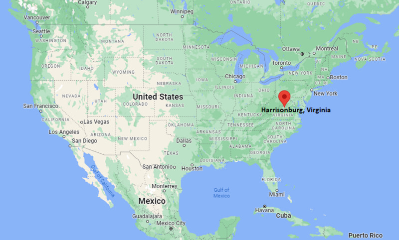
Harrisonburg Map, Virginia, USA
Where is Harrisonburg?: The Google Map showing the location of Harrisonburg in the U.S. state of Virginia.
Where is Harrisonburg Located?
Harrisonburg is a city located in the Catahoula County of Virginia, United States. Harrisonburg lies between 33.0145673 Degrees North latitudes and 97.0969552 Degrees West longitudes. According to 2020 U.S.census, the population of Harrisonburg city is 51814 people and the city has a total area of 17.34 sq mi. The city has numerous parks and recreational facilities.
Most Viewed US Maps
| USA Sttae Map | USA Region Map | USA Road Map |
| USA County Map | Where is USA in World Map? | US ZIP Code Map |
| USA Time Zones Map | US State and Capitals Map | USA Physical Map |
Find 4,400+ U.S. Cities by State - Explore Their Locations and Get Detailed Information
Harrisonburg, Virginia Quick Facts
| Property | Information |
|---|---|
| City | Harrisonburg |
| County | Independent City (surrounded by Rockingham County) |
| State | Virginia |
| State Capital | Richmond |
| US Region | Southern United States |
| Latitude | 38.4496°N |
| Longitude | 78.8689°W |
| Elevation | 1,325 ft (404 m) |
| Land Area | 17.35 sq mi |
| Water Area | 0.11 sq mi |
| Total Area | 17.46 sq mi |
| Population (latest Census year) | 51,814 (Census 2020) |
| Population Density | Approximately 2,986 per sq mi |
| ZIP Codes | 22801, 22802, 22803, 22807 |
| Area Code | 540 |
| Time Zone Standard | Eastern Standard Time (EST, UTC−5) |
| Time Zone Daylight | Eastern Daylight Time (EDT, UTC−4) |
| Currency | US Dollar (USD) |
| FIPS Code | 51-35696 |
| Congressional District | Virginia's 6th Congressional District |
Nearby Cities to Harrisonburg, Virginia
- Bridgewater, Virginia — 8 mi South
- Elkton, Virginia — 13 mi East
- Broadway, Virginia — 15 mi North
- Dayton, Virginia — 5 mi Southwest
- Staunton, Virginia — 25 mi South
- Waynesboro, Virginia — 31 mi South
- Luray, Virginia — 33 mi Northeast
- Front Royal, Virginia — 62 mi Northeast
- Charlottesville, Virginia — 58 mi Southeast
- Winchester, Virginia — 82 mi Northeast
Driving Distances from Harrisonburg, Virginia
| City | State | Distance (mi) | Approx. Drive Time |
|---|---|---|---|
| Bridgewater | Virginia | 8 | 12 minutes |
| Dayton | Virginia | 5 | 10 minutes |
| Elkton | Virginia | 13 | 20 minutes |
| Broadway | Virginia | 15 | 20 minutes |
| Staunton | Virginia | 25 | 30 minutes |
| Waynesboro | Virginia | 31 | 35 minutes |
| Luray | Virginia | 33 | 40 minutes |
| Charlottesville | Virginia | 58 | 1 hour |
| Front Royal | Virginia | 62 | 1 hour 10 minutes |
| Richmond | Virginia | 124 | 2 hours 15 minutes |
Transportation and Connectivity in Harrisonburg, Virginia
| Transportation | Details |
|---|---|
| Airport Name | Shenandoah Valley Regional Airport |
| IATA Code | SHD |
| Port | Not Applicable |
| Major Highways | Interstate 81, U.S. Route 33, U.S. Route 11, Virginia Route 42 |
| Train/Amtrak Service | Nearest Amtrak station at Staunton (Amtrak Thruway) or Charlottesville |
| Local Bus/Transit Service | Harrisonburg Department of Public Transportation (HDPT) |
- Interstate 81 is the primary north-south transportation corridor, connecting Harrisonburg with Roanoke, Winchester, and the Mid-Atlantic region.
- U.S. Route 33 crosses the Blue Ridge Mountains, linking the city with Charlottesville and West Virginia.
- U.S. Route 11 provides an alternate scenic route through the Shenandoah Valley.
- Harrisonburg Department of Public Transportation (HDPT) operates local bus routes throughout the city, including service to James Madison University.
- Shenandoah Valley Regional Airport offers commercial flights, while larger domestic and international services are available from nearby airports in Charlottesville and Washington, D.C.
What are top Places to Visit in Harrisonburg, Virginia
| Landmark Name | Type |
|---|---|
| James Madison University | University Campus |
| Edith J. Carrier Arboretum | Botanical Garden |
| Explore More Discovery Museum | Children's Museum |
| Virginia Quilt Museum | Museum |
| Shenandoah Heritage Market | Farm Market |
| Hillandale Park | City Park |
| Shenandoah National Park | National Park |
| George Washington National Forest | National Forest |
| Hardesty-Higgins House Visitor Center | Historic Site |
| Massanutten Resort | Resort & Recreation Area |
Colleges and Universities in Harrisonburg, Virginia
| Institution | Type | Level | Notable For |
|---|---|---|---|
| James Madison University | Public | University | Research university with nationally recognized business, education, and health programs |
| Eastern Mennonite University | Private | University | Liberal arts, peacebuilding, nursing, and graduate studies |
| Blue Ridge Community College | Public | Community College | Career training, technical education, and university transfer programs |
| Bridgewater College | Private | College | Liberal arts and undergraduate education |
| Massanutten Technical Center | Public | Technical Education Center | Career and technical education programs |
Waterbodies in Harrisonburg, Virginia
North River, South Fork Shenandoah River, Dry River, Blacks Run, Smith Creek, Cub Run, Lake Shenandoah, Silver Lake, Mossy Creek, Shenandoah River
Golf Courses in Harrisonburg, Virginia
Heritage Oaks Golf Course, Spotswood Country Club, Lakeview Golf Club, Packsaddle Ridge Golf Club, Massanutten Mountain Greens Golf Course, Massanutten Peak Course, Ingleside Golf Resort, Bryce Resort Golf Course
Harrisonburg, Virginia — Key Historical Facts
- Harrisonburg was founded in 1779 by Thomas Harrison and became an important trading center in Virginia's Shenandoah Valley.
- The city was incorporated in 1849 and later became an independent city, separate from surrounding Rockingham County while remaining its county seat.
- During the American Civil War, Harrisonburg witnessed military activity due to its strategic location along the Shenandoah Valley transportation corridor.
- The establishment and growth of James Madison University transformed Harrisonburg into a major educational, cultural, and economic center.
- Today, Harrisonburg is known for its vibrant downtown, diverse community, higher education institutions, agricultural heritage, and easy access to the Shenandoah National Park and George Washington National Forest.
References
Virginia Maps and Info
- Where is Alexandria
- Where is Annandale
- Where is Ashburn
- Where is Bailey's Crossroads
- Where is Blacksburg
- Where is Brambleton
- Where is Burke
- Where is Cave Spring
- Where is Centreville
- Where is Chantilly
- Where is Charlottesville
- Where is Cherry Hill
- Where is Chester
- Where is Christiansburg
- Where is Dale City
- Where is Danville
- Where is Fair Oaks
- Where is Fairfax
- Where is Fredericksburg
- Where is Hampton
- Where is Harrisonburg
- Where is Herndon
- Where is Lake Ridge
- Where is Leesburg
- Where is Linton Hall
- Where is Lynchburg
- Where is Manassas
- Where is McLean
- Where is Mechanicsville
- Where is Newport News
- Where is Oakton
- Where is Petersburg
- Where is Portsmouth
- Where is Reston
- Where is Roanoke
- Where is Short Pump
- Where is South Riding
- Where is Staunton
- Where is Sterling
- Where is Suffolk
- Where is Tuckahoe
- Where is Winchester
- Where is Woodbridge