
Where is Portsmouth Located? - Portsmouth is a city located in the Bay County of Virginia, United States. Portsmouth lies between 26.2159066 Degrees North latitudes and 98.3252932 Degrees West longitudes.
Location Map of Portsmouth, Virginia
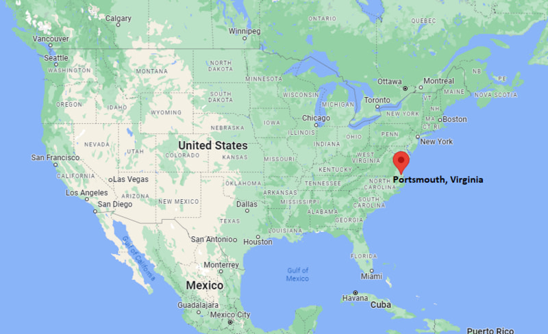
Portsmouth Map, Virginia, USA
Where is Portsmouth?: The Google Map showing the location of Portsmouth in the U.S. state of Virginia.
Where is Portsmouth Located?
Portsmouth is a city located in the Bay County of Virginia, United States. Portsmouth lies between 26.2159066 Degrees North latitudes and 98.3252932 Degrees West longitudes. According to 2020 U.S.census, the population of Portsmouth city is 97915 people and the city has a total area of 33.3 sq mi. The city has numerous parks and recreational facilities.
Most Viewed US Maps
| USA Sttae Map | USA Region Map | USA Road Map |
| USA County Map | Where is USA in World Map? | US ZIP Code Map |
| USA Time Zones Map | US State and Capitals Map | USA Physical Map |
Find 4,400+ U.S. Cities by State - Explore Their Locations and Get Detailed Information
Portsmouth, Virginia Quick Facts
| Attribute | Details |
|---|---|
| City | Portsmouth |
| County | Independent City (not part of a county) |
| State | Virginia |
| State Capital | Richmond |
| US Region | Southern United States (South Atlantic Region) |
| Latitude | 36.8354° N |
| Longitude | 76.2983° W |
| Elevation | 20 ft (6 m) |
| Land Area | 33.28 sq mi |
| Water Area | 25.80 sq mi |
| Total Area | 59.08 sq mi |
| Population (2020 Census) | 97,915 |
| Population Density | Approximately 2,942 people per sq mi |
| ZIP Codes | 23701, 23702, 23703, 23704, 23707, 23708, 23709 |
| Area Code | 757 |
| Time Zone Standard | Eastern Standard Time (EST, UTC−5) |
| Time Zone Daylight | Eastern Daylight Time (EDT, UTC−4) |
| Currency | United States Dollar (USD) |
| FIPS Code | 51-64000 |
| Congressional District | Virginia's 3rd Congressional District |
Transportation and Connectivity in Portsmouth
| Category | Details |
|---|---|
| Airport Name | Norfolk International Airport |
| IATA Code | ORF |
| Port | Portsmouth Marine Terminal and Hampton Roads Harbor |
| Major Highways | Interstate 264, U.S. Route 17, U.S. Route 58, U.S. Route 460 |
| Train/Amtrak Service | Amtrak service available in nearby Norfolk and Newport News |
| Local Bus/Transit Service | Hampton Roads Transit (HRT) |
- Interstate 264 – Main highway connecting Portsmouth with Norfolk, Chesapeake, and Virginia Beach.
- U.S. Route 17 – Regional highway connecting Portsmouth with communities along the Hampton Roads area.
- U.S. Route 58 – Major east–west route linking Portsmouth with southern Virginia.
- U.S. Route 460 – Important highway connecting Portsmouth with central and western Virginia.
Top Places to Visit in Portsmouth, Virginia
| Landmark Name | Type |
|---|---|
| Portsmouth Naval Shipyard Museum | Maritime Museum |
| Children's Museum of Virginia | Family Museum |
| Virginia Sports Hall of Fame and Museum | Sports Museum |
| Olde Towne Portsmouth Historic District | Historic District |
| Portsmouth Naval Hospital | Historic Military Site |
| Paradise Creek Nature Park | Nature Park |
| Portsmouth Waterfront | Waterfront Area |
| Hoffler Creek Wildlife Preserve | Wildlife Preserve |
| High Street Landing | Riverfront Attraction |
| MacArthur Memorial | Historic Museum |
Driving Distances from Portsmouth, Virginia to Nearby Cities
| City | State | Distance (mi) | Approx. Drive Time |
|---|---|---|---|
| Norfolk | Virginia | 5 | 15 minutes |
| Chesapeake | Virginia | 15 | 25 minutes |
| Virginia Beach | Virginia | 25 | 40 minutes |
| Newport News | Virginia | 30 | 45 minutes |
| Williamsburg | Virginia | 55 | 1 hour |
| Richmond | Virginia | 95 | 1 hour 40 minutes |
| Washington, D.C. | District of Columbia | 200 | 3 hours 15 minutes |
| Raleigh | North Carolina | 190 | 3 hours |
| Charlotte | North Carolina | 280 | 4 hours 30 minutes |
| Baltimore | Maryland | 220 | 3 hours 30 minutes |
Colleges and Universities Near Portsmouth, Virginia
| Institution Name | Type | Level | Notable For |
|---|---|---|---|
| Old Dominion University | Public | University | Research, engineering, business, maritime studies, and sciences |
| Tidewater Community College | Public | Community College | Workforce training, technical programs, and associate degrees |
| Norfolk State University | Public | University | Education, business, engineering, and liberal arts |
| Christopher Newport University | Public | University | Liberal arts, sciences, and leadership programs |
| Regent University | Private | University | Law, business, communication, and graduate studies |
| Portsmouth Public Schools | Public | K–12 District | Primary and secondary education |
Waterbodies in Portsmouth, Virginia
Elizabeth River, Southern Branch Elizabeth River, Hampton Roads Harbor, Chesapeake Bay, and nearby Atlantic coastal waterways.
Golf Courses Near Portsmouth
Elizabeth Manor Country Club, Bide-A-Wee Golf Course, Riverfront Golf Club, Chesapeake Golf Club, and Sleepy Hole Golf Course.
Portsmouth, Virginia — Key Historical Facts
- Portsmouth was founded in 1752 by William Crawford and developed as an important shipbuilding and maritime community.
- The city's location along the Elizabeth River helped it become a major center for naval operations and commerce.
- The Norfolk Naval Shipyard, established in 1767, has played a significant role in Portsmouth's history and economy.
- Portsmouth served as an important military location during the American Revolution, Civil War, and later conflicts.
- Today, Portsmouth is known for its naval heritage, historic districts, waterfront attractions, and connection to the Hampton Roads metropolitan area.
References
- City of Portsmouth
- U.S. Census Bureau
- Virginia Tourism Corporation
- National Park Service
- Naval History and Heritage Command
Virginia Maps and Info
- Where is Alexandria
- Where is Annandale
- Where is Ashburn
- Where is Bailey's Crossroads
- Where is Blacksburg
- Where is Brambleton
- Where is Burke
- Where is Cave Spring
- Where is Centreville
- Where is Chantilly
- Where is Charlottesville
- Where is Cherry Hill
- Where is Chester
- Where is Christiansburg
- Where is Dale City
- Where is Danville
- Where is Fair Oaks
- Where is Fairfax
- Where is Fredericksburg
- Where is Hampton
- Where is Harrisonburg
- Where is Herndon
- Where is Lake Ridge
- Where is Leesburg
- Where is Linton Hall
- Where is Lynchburg
- Where is Manassas
- Where is McLean
- Where is Mechanicsville
- Where is Newport News
- Where is Oakton
- Where is Petersburg
- Where is Portsmouth
- Where is Reston
- Where is Roanoke
- Where is Short Pump
- Where is South Riding
- Where is Staunton
- Where is Sterling
- Where is Suffolk
- Where is Tuckahoe
- Where is Winchester
- Where is Woodbridge