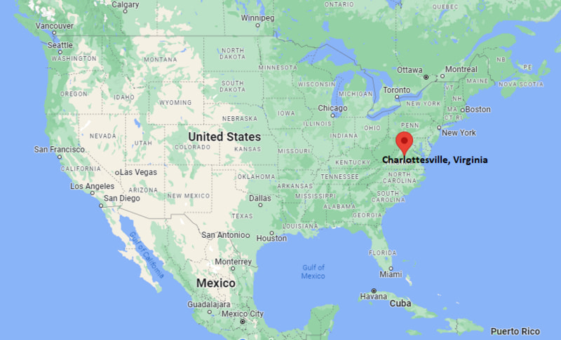
Where is Charlottesville Located? - Charlottesville is a city located in the Albemarle County of Virginia, United States. Charlottesville lies between 30.6332618 Degrees North latitudes and 97.6779842 Degrees West longitudes.
Location Map of Charlottesville, Virginia
Charlottesville Map, Virginia, USA
Where is Charlottesville?: The Google Map showing the location of Charlottesville in the U.S. state of Virginia.
Where is Charlottesville Located?
Charlottesville is a city located in the Albemarle County of Virginia, United States. Charlottesville lies between 30.6332618 Degrees North latitudes and 97.6779842 Degrees West longitudes. According to 2020 U.S.census, the population of Charlottesville city is 46553 people and the city has a total area of 10.24 sq mi. The city has numerous parks and recreational facilities.
Nearby Cities and Towns to Charlottesville, Virginia
Crozet, Virginia - 12 mi
Scottsville, Virginia - 20 mi
Waynesboro, Virginia - 27 mi
Staunton, Virginia - 38 mi
Orange, Virginia - 28 mi
Harrisonburg, Virginia - 55 mi
Culpeper, Virginia - 45 mi
Louisa, Virginia - 34 mi
Richmond, Virginia - 71 mi
Lynchburg, Virginia - 68 mi
Charlottesville, Virginia Climate and Weather Overview
Month
Avg High (°F)
Avg Low (°F)
Avg Rainfall (in)
January
45
26
3.2
April
69
45
3.4
July
88
67
4.2
October
70
46
3.2
Annual
68
46
46.3
Climate Attribute
Details
Climate Classification (Köppen)
Humid Subtropical (Cfa)
Annual Rainfall
About 46.3 in
Annual Sunshine Days
About 219 days
Hurricane/Tornado Risk
Low hurricane risk and low tornado risk
Snowfall
About 17 in annually
Driving Distances from Charlottesville, Virginia
City
State
Distance (mi)
Approx. Drive Time
Crozet
Virginia
12
20 min
Scottsville
Virginia
20
30 min
Waynesboro
Virginia
27
35 min
Orange
Virginia
28
35 min
Louisa
Virginia
34
40 min
Staunton
Virginia
38
45 min
Culpeper
Virginia
45
1 hr
Harrisonburg
Virginia
55
1 hr
Lynchburg
Virginia
68
1 hr 20 min
Richmond
Virginia
71
1 hr 20 min
Transportation and Connectivity in Charlottesville, Virginia
Transportation
Details
Airport Name
Charlottesville Albemarle Airport
IATA Code
CHO
Port
No commercial port
Major Highways
Interstate 64, U.S. Route 29, U.S. Route 250, Virginia State Route 20
Train/Amtrak Service
Amtrak Northeast Regional and Cardinal services at Charlottesville Union Station
Local Bus/Transit Service
Charlottesville Area Transit (CAT) and University Transit Service (UTS)
Interstate 64 and U.S. Routes 29 and 250 provide direct highway access to Richmond, Staunton, Lynchburg, and Washington, D.C.
Charlottesville Albemarle Airport offers scheduled flights to several major U.S. airline hubs.
Amtrak provides passenger rail service with direct connections to Washington, D.C., New York City, Chicago, and other destinations.
Charlottesville Area Transit (CAT) and University Transit Service (UTS) provide public transportation throughout the city and the University of Virginia campus.
Charlottesville is internationally known as the home of the University of Virginia and for its close association with Thomas Jefferson and Monticello.
Key Landmarks and Places to Visit in Charlottesville, Virginia
Landmark Name
Type
Monticello
UNESCO World Heritage Site
University of Virginia
Historic University Campus
The Rotunda
Historic Landmark
Downtown Mall
Pedestrian Shopping District
Carter Mountain Orchard
Orchard and Scenic Attraction
Ix Art Park
Art Park
Virginia Discovery Museum
Children's Museum
Kluge-Ruhe Aboriginal Art Collection
Art Museum
Rivanna Trails
Hiking Trail System
James Monroe's Highland
Historic Estate
Colleges and Universities in and near Charlottesville, Virginia
Institution Name
Type
Level
Notable For
University of Virginia
Public
University
Law, medicine, engineering, business, and world-class research
Piedmont Virginia Community College
Public
Community College
Transfer programs, workforce training, and technical education
James Madison University
Public
University
Education, business, health sciences, and engineering
Liberty University
Private
University
Business, aviation, healthcare, and online education
Mary Baldwin University
Private
University
Health sciences, education, liberal arts, and graduate programs
Waterbodies in Charlottesville, Virginia
Rivanna River, South Fork Rivanna River, Sugar Hollow Reservoir, Beaver Creek Reservoir, Ragged Mountain Reservoir, Chris Greene Lake, Totier Creek, Mechums River
Golf Courses in and near Charlottesville, Virginia
Birdwood Golf Course, Farmington Country Club, Meadowcreek Golf Course, Glenmore Country Club, Old Trail Golf Club, Spring Creek Golf Club, Keswick Hall Golf Club, Forest Lakes Golf Club
Charlottesville, Virginia - Key Historical Facts
Charlottesville was founded in 1762 and named in honor of Queen Charlotte, the wife of King George III of Great Britain.
The city became closely associated with Thomas Jefferson, whose nearby estate, Monticello, and founding of the University of Virginia shaped its history and identity.
The University of Virginia, established in 1819, became one of the nation's leading public universities and is recognized as a UNESCO World Heritage Site along with Monticello.
During the nineteenth century, Charlottesville grew as a regional center for agriculture, commerce, and transportation following the arrival of the railroad.
The city has developed into an important hub for education, healthcare, technology, tourism, and cultural activities while preserving its historic architecture.
Today, Charlottesville is known for its presidential history, vibrant downtown, wineries, scenic Blue Ridge Mountain setting, and nationally recognized academic and medical institutions.