Map of Albemarle County - Albemarle County is a county located in the U.S. state of Virginia. Albemarle County Map showing cities, highways, important places and water bodies. Get Where is Albemarle County located in the map, major cities in Albemarle county, population, areas, and places of interest.
Map of Albemarle County, Virginia
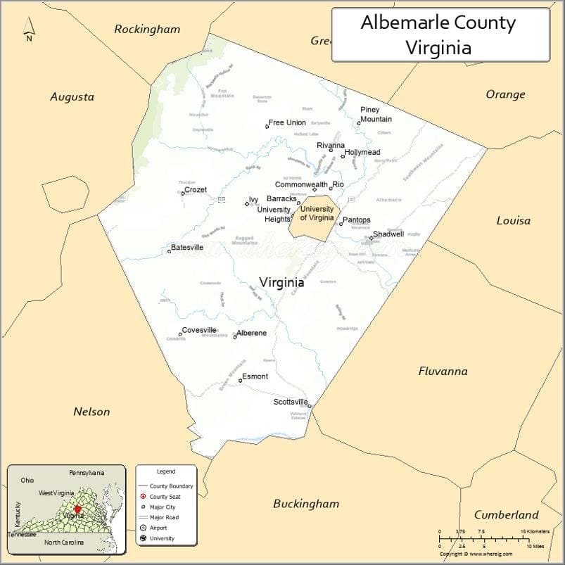
About Albemarle County Map, Alabama: The map showing the county boundary, county seat, major cities, highways, water bodies and neighbouring counties.
Related Virginia Links
| Virginia Map | Counties in Virginia | Cities in Virginia |
| Airports in Virginia | Zip Codes in Virginia | Where is Virginia |
| Where is Richmond | Where is Chesapeake | Where is Virginia Beach |
Map of Albemarle County, Virginia
Covington County is a county located in the U.S. state of Virginia. It`s county seat is N/A. As per 2020 census, the population of Covington County was 5717 and population density of Covington was square miles. According to the United States Census Bureau, the county has a total area of 4 sq mi (10 km2). Covington County was established on 1952.
Albemarle County Facts
| Continent | North America |
| Country | United States |
| State | Virginia |
| County Seat | Charlottesville |
| Largest City/Town | Charlottesville |
| Established | 1744 |
| Total Area | 726 sq mi (1,880 sq km) |
| Land Area | 718 sq mi (1,860 sq km) |
| Water Area | 8 sq mi (21 sq km) |
| Population | 112,395 (Census 2020) |
| Population Density | 156 people per sq mi |
| Time Zone | Eastern (EST) |
| Major Highways | I-64, US-29, US-250, US-20 |
| Major Rivers | Rivanna River, James River |
| Neighboring Counties | Greene County, Orange County, Louisa County, Fluvanna County, Buckingham County, Nelson County, Augusta County, Rockingham County |
| Famous For | University of Virginia, Monticello, scenic Blue Ridge Mountains |
| Top Attractions | Monticello, University of Virginia, Shenandoah National Park, Carter Mountain Orchard |
| Official Website | Official Website |
About Albemarle County, Virginia
Albemarle County is located in the central part of Virginia in the state of the United States, and was established in 1744. The county surrounds the independent city of Charlottesville, which serves as the county seat and largest urban center. The area features rolling hills, farmland, and parts of the Blue Ridge Mountains, making it one of the most scenic regions in the state.
Cities and Towns in Albemarle County, Virginia
| City/Town | Population (Census 2020) | Latitude & Longitude |
|---|---|---|
| Charlottesville (county seat) | 46,553 | 38.0293°N, 78.4767°W |
| Crozet (CDP) | 7,565 | 38.0704°N, 78.7006°W |
| Scottsville (partly) | 566 | 37.7982°N, 78.4956°W |
| Ivy (CDP) | 905 | 38.0562°N, 78.5964°W |
| Keswick (CDP) | 1,360 | 38.0276°N, 78.3475°W |
| Hollymead (CDP) | 9,230 | 38.1268°N, 78.4436°W |
| Pantops (CDP) | 3,027 | 38.0318°N, 78.4340°W |
| Lake Monticello (CDP) | 10,381 | 37.9237°N, 78.3261°W |
| North Garden (CDP) | 350 | 37.9495°N, 78.6111°W |
| Earlysville (CDP) | 1,300 | 38.1537°N, 78.4806°W |
| Free Union (CDP) | 200 | 38.1501°N, 78.7128°W |
| Greenwood (CDP) | 500 | 38.0470°N, 78.7642°W |
| Keene (CDP) | 400 | 37.8838°N, 78.5714°W |
| White Hall (CDP) | 150 | 38.1554°N, 78.6650°W |
Golf Courses in Albemarle County, Virginia
| Golf Course | Location | Latitude & Longitude |
|---|---|---|
| Birdwood Golf Course | Charlottesville | 38.0406°N, 78.5137°W |
| Glenmore Country Club | Keswick | 38.0350°N, 78.3350°W |
| Old Trail Golf Club | Crozet | 38.0629°N, 78.7040°W |
| Spring Creek Golf Club | Zion Crossroads | 37.9782°N, 78.2155°W |
Roads and Highways in Albemarle County, Virginia
The county is well connected through a network of major highways and scenic routes.
- I-64 – east-west route connecting Richmond and Staunton
- US-29 – north-south corridor linking Charlottesville with Washington, DC and Lynchburg
- US-250 – connects the county to Richmond and the Shenandoah Valley
- US-20 – scenic route running north-south through rural areas
Neighboring Counties of Albemarle County
- Greene County (north)
- Orange County (northeast)
- Louisa County (east)
- Fluvanna County (southeast)
- Buckingham County (south)
- Nelson County (southwest)
- Augusta County (west)
- Rockingham County (northwest)
Top Attractions in Albemarle County, Virginia
The county is rich in history, culture, and outdoor beauty.
- Monticello – historic home of Thomas Jefferson and UNESCO World Heritage Site
- University of Virginia – iconic campus designed by Jefferson
- Shenandoah National Park – scenic drives and hiking trails along the Blue Ridge
- Carter Mountain Orchard – popular spot for apple picking and mountain views
- James Monroe’s Highland – former home of the fifth U.S. president
- Rivanna River Trail – outdoor recreation and walking paths
- Keswick Vineyards – local winery with scenic countryside views
- Blue Ridge Parkway – nearby scenic roadway with overlooks and trails
Distance from Albemarle County to Nearby Cities
- Charlottesville to Richmond, VA – 70 mi (113 km)
- Charlottesville to Washington, DC – 115 mi (185 km)
- Charlottesville to Lynchburg, VA – 65 mi (105 km)
- Charlottesville to Staunton, VA – 40 mi (64 km)
- Charlottesville to Harrisonburg, VA – 55 mi (89 km)
FAQs about Albemarle County
Albemarle County is located in central Virginia and surrounds the independent city of Charlottesville.
The population of Albemarle County is 112,395 according to the 2020 Census.
The county is known for Monticello, the University of Virginia, scenic mountains, and historic landmarks.
The main highways include Interstate 64, US-29, US-250, and US-20.
Yes, Albemarle County has several golf courses including Birdwood Golf Course, Glenmore Country Club, Old Trail Golf Club, and Spring Creek Golf Club.
- Accomack County Map, VA
- Albemarle County Map, VA
- Alleghany County Map, VA
- Amelia County Map, VA
- Amherst County Map, VA
- Appomattox County Map, VA
- Arlington County Map, VA
- Augusta County Map, VA
- Bath County Map, VA
- Bedford County Map, VA
- Bland County Map, VA
- Botetourt County Map, VA
- Brunswick County Map, VA
- Buchanan County Map, VA
- Buckingham County Map, VA
- Campbell County Map, VA
- Caroline County Map, VA
- Carroll County Map, VA
- Charles City County Map, VA
- Charlotte County Map, VA
- Chesterfield County Map, VA
- Clarke County Map, VA
- Craig County Map, VA
- Culpeper County Map, VA
- Cumberland County Map, VA
- Dickenson County Map, VA
- Dinwiddie County Map, VA
- Essex County Map, VA
- Fairfax County Map, VA
- Fauquier County Map, VA
- Floyd County Map, VA
- Fluvanna County Map, VA
- Franklin County Map, VA
- Frederick County Map, VA
- Giles County Map, VA
- Gloucester County Map, VA
- Goochland County Map, VA
- Grayson County Map, VA
- Greene County Map, VA
- Greensville County Map, VA
- Halifax County Map, VA
- Hanover County Map, VA
- Henrico County Map, VA
- Henry County Map, VA
- Highland County Map, VA
- Isle of Wight County Map, VA
- James City County Map, VA
- King and Queen County Map, VA
- King George County Map, VA
- King William County Map, VA
- Lancaster County Map, VA
- Lee County Map, VA
- Loudoun County Map, VA
- Louisa County Map, VA
- Lunenburg County Map, VA
- Madison County Map, VA
- Mathews County Map, VA
- Mecklenburg County Map, VA
- Middlesex County Map, VA
- Montgomery County Map, VA
- Nelson County Map, VA
- New Kent County Map, VA
- Northampton County Map, VA
- Northumberland County Map, VA
- Nottoway County Map, VA
- Orange County Map, VA
- Page County Map, VA
- Patrick County Map, VA
- Pittsylvania County Map, VA
- Powhatan County Map, VA
- Prince Edward County Map, VA
- Prince George County Map, VA
- Prince William County Map, VA
- Pulaski County Map, VA
- Rappahannock County Map, VA
- Richmond County Map, VA
- Roanoke County Map, VA
- Rockbridge County Map, VA
- Rockingham County Map, VA
- Russell County Map, VA
- Scott County Map, VA
- Shenandoah County Map, VA
- Smyth County Map, VA
- Southampton County Map, VA
- Spotsylvania County Map, VA
- Stafford County Map, VA
- Surry County Map, VA
- Sussex County Map, VA
- Tazewell County Map, VA
- Warren County Map, VA
- Washington County Map, VA
- Westmoreland County Map, VA
- Wise County Map, VA
- Wythe County Map, VA
- York County Map, VA
- Alexandria County Map, VA
- Bristol County Map, VA
- Buena Vista County Map, VA
- Charlottesville County Map, VA
- Chesapeake County Map, VA
- Colonial Heights County Map, VA
- Covington County Map, VA
- Danville County Map, VA
- Emporia County Map, VA
- Fairfax County Map, VA
- Falls Church County Map, VA
- Alabama Counties
- Alaska boroughs
- Arizona Counties
- Arkansas Counties
- California County Map
- Colorado Counties
- Connecticut Counties
- Delaware Counties
- Florida County Map
- Georgia County Map
- Hawaii Counties
- Idaho Counties
- Illinois Counties
- Indiana Counties
- Iowa Counties
- Kansas Counties
- Kentucky Counties
- Louisiana Counties
- Maine Counties
- Maryland Counties
- Massachusetts Counties
- Michigan County Map
- Minnesota Counties
- Mississippi Counties
- Missouri Counties
- Montana Counties
- Nebraska Counties
- Nevada Counties
- New York Counties
- New Hampshire Counties
- New Jersey Counties
- New Mexico Counties
- North Carolina Counties
- North Dakota Counties
- Ohio County Map
- Oklahoma Counties
- Oregon Counties
- Pennsylvania Counties
- Rhode Island Counties
- South Carolina Counties
- South Dakota Counties
- Map of Tennessee
- Texas County Map
- Utah Counties
- Vermont Counties
- Virginia Counties
- Washington Counties
- West Virginia Counties
- Wisconsin Counties
- Wyoming Counties