Map of Northampton County - Northampton County is a county located in the U.S. state of Virginia. Northampton County Map showing cities, highways, important places and water bodies. Get Where is Northampton County located in the map, major cities in Northampton county, population, areas, and places of interest.
Map of Northampton County, Virginia
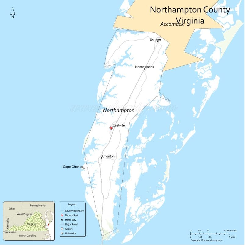
About Northampton County Map, Alabama: The map showing the county boundary, county seat, major cities, highways, water bodies and neighbouring counties.
Related Virginia Links
| Virginia Map | Counties in Virginia | Cities in Virginia |
| Airports in Virginia | Zip Codes in Virginia | Where is Virginia |
| Where is Richmond | Where is Chesapeake | Where is Virginia Beach |
Map of Northampton County, Virginia
Stevens County is a county located in the U.S. state of Washington. It`s county seat is Colville. As per 2020 census, the population of Stevens County was 46445 and population density of Stevens was square miles. According to the United States Census Bureau, the county has a total area of 2,478 sq mi (6,418 km2). Stevens County was established on 1863.
Northampton County Facts
| Continent | North America |
| Country | United States |
| State | Virginia |
| County Seat | Eastville |
| Largest City/Town | Nassawadox |
| Established | 1634 |
| Total Area | 795 sq mi (2,060 sq km) |
| Land Area | 212 sq mi (549 sq km) |
| Water Area | 583 sq mi (1,511 sq km) |
| Population | 11,062 (Census 2020) |
| Population Density | 52 people per sq mi (land only) |
| Time Zone | Eastern (EST) |
| Major Highways | US-13 |
| Major Rivers | Chesapeake Bay, Atlantic Ocean coastline |
| Neighboring Counties | Accomack County (north) |
| Famous For | Eastern Shore, coastal landscapes, NASA Wallops proximity |
| Top Attractions | Cape Charles Beach, Eastern Shore of Virginia National Wildlife Refuge, Kiptopeke State Park |
| Official Website | Official Website |
About Northampton County, Virginia
Northampton County is located in the eastern part of Virginia on the Eastern Shore of the United States, and was established in 1634. The county seat is Eastville, while Nassawadox is the largest town. The county lies between the Chesapeake Bay and the Atlantic Ocean and is known for its coastal scenery, historic sites, and outdoor recreation.
Cities and Towns in Northampton County, Virginia
| City/Town | Population (Census 2020) | Latitude & Longitude |
|---|---|---|
| Nassawadox (town) | 500 | 37.4700°N, 75.8600°W |
| Cape Charles (town) | 1,100 | 37.2700°N, 76.0200°W |
| Cheriton (town) | 500 | 37.2800°N, 75.9700°W |
| Eastville (county seat, town) | 200 | 37.3500°N, 75.9500°W |
| Exmore (town, partly in county) | 1,300 | 37.5300°N, 75.8300°W |
| Franktown (CDP) | 200 | 37.4500°N, 75.8900°W |
Golf Courses in Northampton County, Virginia
| Golf Course | Location | Latitude & Longitude |
|---|---|---|
| Bay Creek Golf Club | Cape Charles | 37.2700°N, 76.0200°W |
| Eastern Shore Yacht & Country Club (nearby) | Melfa area | 37.6400°N, 75.7400°W |
Roads and Highways in Northampton County, Virginia
The county is connected by a major highway along the Eastern Shore.
- US-13 – primary route running north-south through the Eastern Shore
Neighboring Counties of Northampton County
- Accomack County (north)
Top Attractions in Northampton County, Virginia
The county offers coastal recreation and natural beauty.
- Cape Charles Beach – sandy beach along Chesapeake Bay
- Kiptopeke State Park – camping, fishing, and wildlife
- Eastern Shore of Virginia National Wildlife Refuge – birdwatching and nature
- Bay Creek Resort – golf and waterfront living
- Barrier islands – protected coastal habitats
Distance from Northampton County to Nearby Cities
- Cape Charles to Norfolk, VA – 45 mi (72 km)
- Cape Charles to Virginia Beach, VA – 50 mi (80 km)
- Cape Charles to Richmond, VA – 120 mi (193 km)
- Cape Charles to Washington, DC – 200 mi (322 km)
- Cape Charles to Baltimore, MD – 180 mi (290 km)
FAQs about Northampton County
Northampton County is located on the Eastern Shore of Virginia between the Chesapeake Bay and the Atlantic Ocean.
The population of Northampton County is 11,062 according to the 2020 Census.
The county is known for its coastal landscapes, beaches, and wildlife refuges.
The main highway is US-13, which runs through the Eastern Shore.
Yes, Northampton County has golf courses such as Bay Creek Golf Club.
- Accomack County Map, VA
- Albemarle County Map, VA
- Alleghany County Map, VA
- Amelia County Map, VA
- Amherst County Map, VA
- Appomattox County Map, VA
- Arlington County Map, VA
- Augusta County Map, VA
- Bath County Map, VA
- Bedford County Map, VA
- Bland County Map, VA
- Botetourt County Map, VA
- Brunswick County Map, VA
- Buchanan County Map, VA
- Buckingham County Map, VA
- Campbell County Map, VA
- Caroline County Map, VA
- Carroll County Map, VA
- Charles City County Map, VA
- Charlotte County Map, VA
- Chesterfield County Map, VA
- Clarke County Map, VA
- Craig County Map, VA
- Culpeper County Map, VA
- Cumberland County Map, VA
- Dickenson County Map, VA
- Dinwiddie County Map, VA
- Essex County Map, VA
- Fairfax County Map, VA
- Fauquier County Map, VA
- Floyd County Map, VA
- Fluvanna County Map, VA
- Franklin County Map, VA
- Frederick County Map, VA
- Giles County Map, VA
- Gloucester County Map, VA
- Goochland County Map, VA
- Grayson County Map, VA
- Greene County Map, VA
- Greensville County Map, VA
- Halifax County Map, VA
- Hanover County Map, VA
- Henrico County Map, VA
- Henry County Map, VA
- Highland County Map, VA
- Isle of Wight County Map, VA
- James City County Map, VA
- King and Queen County Map, VA
- King George County Map, VA
- King William County Map, VA
- Lancaster County Map, VA
- Lee County Map, VA
- Loudoun County Map, VA
- Louisa County Map, VA
- Lunenburg County Map, VA
- Madison County Map, VA
- Mathews County Map, VA
- Mecklenburg County Map, VA
- Middlesex County Map, VA
- Montgomery County Map, VA
- Nelson County Map, VA
- New Kent County Map, VA
- Northampton County Map, VA
- Northumberland County Map, VA
- Nottoway County Map, VA
- Orange County Map, VA
- Page County Map, VA
- Patrick County Map, VA
- Pittsylvania County Map, VA
- Powhatan County Map, VA
- Prince Edward County Map, VA
- Prince George County Map, VA
- Prince William County Map, VA
- Pulaski County Map, VA
- Rappahannock County Map, VA
- Richmond County Map, VA
- Roanoke County Map, VA
- Rockbridge County Map, VA
- Rockingham County Map, VA
- Russell County Map, VA
- Scott County Map, VA
- Shenandoah County Map, VA
- Smyth County Map, VA
- Southampton County Map, VA
- Spotsylvania County Map, VA
- Stafford County Map, VA
- Surry County Map, VA
- Sussex County Map, VA
- Tazewell County Map, VA
- Warren County Map, VA
- Washington County Map, VA
- Westmoreland County Map, VA
- Wise County Map, VA
- Wythe County Map, VA
- York County Map, VA
- Alexandria County Map, VA
- Bristol County Map, VA
- Buena Vista County Map, VA
- Charlottesville County Map, VA
- Chesapeake County Map, VA
- Colonial Heights County Map, VA
- Covington County Map, VA
- Danville County Map, VA
- Emporia County Map, VA
- Fairfax County Map, VA
- Falls Church County Map, VA
- Alabama Counties
- Alaska boroughs
- Arizona Counties
- Arkansas Counties
- California County Map
- Colorado Counties
- Connecticut Counties
- Delaware Counties
- Florida County Map
- Georgia County Map
- Hawaii Counties
- Idaho Counties
- Illinois Counties
- Indiana Counties
- Iowa Counties
- Kansas Counties
- Kentucky Counties
- Louisiana Counties
- Maine Counties
- Maryland Counties
- Massachusetts Counties
- Michigan County Map
- Minnesota Counties
- Mississippi Counties
- Missouri Counties
- Montana Counties
- Nebraska Counties
- Nevada Counties
- New York Counties
- New Hampshire Counties
- New Jersey Counties
- New Mexico Counties
- North Carolina Counties
- North Dakota Counties
- Ohio County Map
- Oklahoma Counties
- Oregon Counties
- Pennsylvania Counties
- Rhode Island Counties
- South Carolina Counties
- South Dakota Counties
- Map of Tennessee
- Texas County Map
- Utah Counties
- Vermont Counties
- Virginia Counties
- Washington Counties
- West Virginia Counties
- Wisconsin Counties
- Wyoming Counties