Map of Fairfax County - Fairfax County is a county located in the U.S. state of Virginia. Fairfax County Map showing cities, highways, important places and water bodies. Get Where is Fairfax County located in the map, major cities in Fairfax county, population, areas, and places of interest.
Map of Fairfax County, Virginia
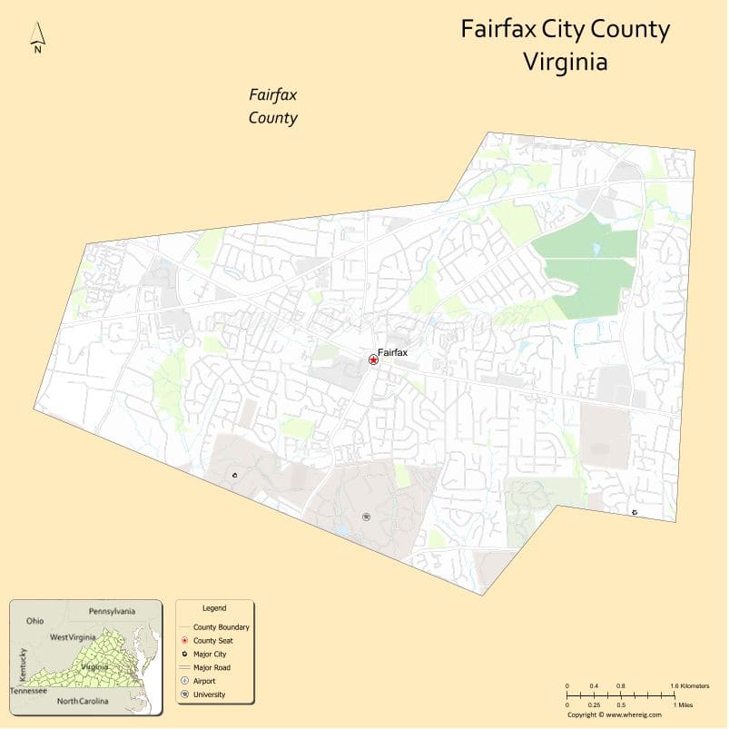
About Fairfax County Map, Alabama: The map showing the county boundary, county seat, major cities, highways, water bodies and neighbouring counties.
Related Virginia Links
| Virginia Map | Counties in Virginia | Cities in Virginia |
| Airports in Virginia | Zip Codes in Virginia | Where is Virginia |
| Where is Richmond | Where is Chesapeake | Where is Virginia Beach |
Map of Fairfax County, Virginia
Pendleton County is a county located in the U.S. state of West Virginia. It`s county seat is Franklin. As per 2020 census, the population of Pendleton County was 6142 and population density of Pendleton was square miles. According to the United States Census Bureau, the county has a total area of 698 sq mi (1,808 km2). Pendleton County was established on 1788.
Fairfax County Facts
| Continent | North America |
| Country | United States |
| State | Virginia |
| County Seat | Fairfax |
| Largest City/Town | Annandale |
| Established | 1742 |
| Total Area | 406 sq mi (1,051 sq km) |
| Land Area | 391 sq mi (1,012 sq km) |
| Water Area | 15 sq mi (39 sq km) |
| Population | 1,150,309 (Census 2020) |
| Population Density | 2,940 people per sq mi |
| Time Zone | Eastern (EST) |
| Major Highways | I-66, I-95, I-495, US-50, US-29 |
| Major Rivers | Potomac River, Occoquan River |
| Neighboring Counties | Arlington County, Loudoun County, Prince William County, Alexandria (independent city), Falls Church (independent city) |
| Famous For | Washington, D.C. suburbs, government and tech hubs, diverse population |
| Top Attractions | Great Falls Park, Mount Vernon, Tysons Corner |
| Official Website | Official Website |
About Fairfax County, Virginia
Fairfax County is located in the northern part of Virginia in the state of the United States, and was established in 1742. The county seat is Fairfax, while Annandale is one of its largest communities. The county borders Washington, D.C., and is part of the Washington metropolitan area, known for its strong economy, diverse population, and proximity to federal government institutions.
Cities and Towns in Fairfax County, Virginia
| City/Town | Population (Census 2020) | Latitude & Longitude |
|---|---|---|
| Fairfax (county seat, independent city) | 24,146 | 38.8462°N, 77.3064°W |
| Annandale (CDP) | 43,000 | 38.8304°N, 77.1964°W |
| Reston (CDP) | 63,226 | 38.9586°N, 77.3570°W |
| McLean (CDP) | 50,000 | 38.9343°N, 77.1775°W |
| Springfield (CDP) | 31,339 | 38.7893°N, 77.1872°W |
| Herndon (town) | 24,655 | 38.9696°N, 77.3861°W |
| Vienna (town) | 16,473 | 38.9012°N, 77.2653°W |
| Falls Church (independent city) | 14,658 | 38.8823°N, 77.1711°W |
Golf Courses in Fairfax County, Virginia
| Golf Course | Location | Latitude & Longitude |
|---|---|---|
| Penderbrook Golf Club | Fairfax | 38.8710°N, 77.3740°W |
| Westfields Golf Club | Clifton | 38.8430°N, 77.4300°W |
| Pohick Bay Golf Course | Lorton | 38.6930°N, 77.2160°W |
| Oak Marr Golf Complex | Oakton | 38.8900°N, 77.3000°W |
Roads and Highways in Fairfax County, Virginia
The county is a major transportation hub in the Washington metropolitan area.
- I-66 – connects Fairfax County to Washington, D.C., and western Virginia
- I-95 – major north-south interstate along the East Coast
- I-495 (Capital Beltway) – encircles Washington, D.C.
- US-50 – major east-west route
- US-29 – connects to Washington, D.C., and central Virginia
Neighboring Counties of Fairfax County
- Arlington County (east)
- Loudoun County (northwest)
- Prince William County (southwest)
- Alexandria (independent city) (east)
- Falls Church (independent city) (east)
Top Attractions in Fairfax County, Virginia
The county offers a mix of historic sites, parks, and urban amenities.
- Great Falls Park – scenic waterfalls and hiking trails along the Potomac River
- George Washington’s Mount Vernon – historic estate of the first U.S. president
- Tysons Corner – major shopping and business district
- National Air and Space Museum Steven F. Udvar-Hazy Center – aviation exhibits
- Burke Lake Park – outdoor recreation and boating
- Wolf Trap National Park for the Performing Arts – concerts and performances
Distance from Fairfax County to Nearby Cities
- Fairfax to Washington, DC – 20 mi (32 km)
- Fairfax to Arlington, VA – 15 mi (24 km)
- Fairfax to Alexandria, VA – 18 mi (29 km)
- Fairfax to Richmond, VA – 100 mi (161 km)
- Fairfax to Baltimore, MD – 60 mi (97 km)
FAQs about Fairfax County
Fairfax County is located in northern Virginia adjacent to Washington, D.C.
The population of Fairfax County is 1,150,309 according to the 2020 Census.
The county is known for its proximity to Washington, D.C., strong economy, and diverse communities.
The main highways include Interstate 66, Interstate 95, Interstate 495, US-50, and US-29.
Yes, Fairfax County has several golf courses including Westfields Golf Club and Penderbrook Golf Club.
- Accomack County Map, VA
- Albemarle County Map, VA
- Alleghany County Map, VA
- Amelia County Map, VA
- Amherst County Map, VA
- Appomattox County Map, VA
- Arlington County Map, VA
- Augusta County Map, VA
- Bath County Map, VA
- Bedford County Map, VA
- Bland County Map, VA
- Botetourt County Map, VA
- Brunswick County Map, VA
- Buchanan County Map, VA
- Buckingham County Map, VA
- Campbell County Map, VA
- Caroline County Map, VA
- Carroll County Map, VA
- Charles City County Map, VA
- Charlotte County Map, VA
- Chesterfield County Map, VA
- Clarke County Map, VA
- Craig County Map, VA
- Culpeper County Map, VA
- Cumberland County Map, VA
- Dickenson County Map, VA
- Dinwiddie County Map, VA
- Essex County Map, VA
- Fairfax County Map, VA
- Fauquier County Map, VA
- Floyd County Map, VA
- Fluvanna County Map, VA
- Franklin County Map, VA
- Frederick County Map, VA
- Giles County Map, VA
- Gloucester County Map, VA
- Goochland County Map, VA
- Grayson County Map, VA
- Greene County Map, VA
- Greensville County Map, VA
- Halifax County Map, VA
- Hanover County Map, VA
- Henrico County Map, VA
- Henry County Map, VA
- Highland County Map, VA
- Isle of Wight County Map, VA
- James City County Map, VA
- King and Queen County Map, VA
- King George County Map, VA
- King William County Map, VA
- Lancaster County Map, VA
- Lee County Map, VA
- Loudoun County Map, VA
- Louisa County Map, VA
- Lunenburg County Map, VA
- Madison County Map, VA
- Mathews County Map, VA
- Mecklenburg County Map, VA
- Middlesex County Map, VA
- Montgomery County Map, VA
- Nelson County Map, VA
- New Kent County Map, VA
- Northampton County Map, VA
- Northumberland County Map, VA
- Nottoway County Map, VA
- Orange County Map, VA
- Page County Map, VA
- Patrick County Map, VA
- Pittsylvania County Map, VA
- Powhatan County Map, VA
- Prince Edward County Map, VA
- Prince George County Map, VA
- Prince William County Map, VA
- Pulaski County Map, VA
- Rappahannock County Map, VA
- Richmond County Map, VA
- Roanoke County Map, VA
- Rockbridge County Map, VA
- Rockingham County Map, VA
- Russell County Map, VA
- Scott County Map, VA
- Shenandoah County Map, VA
- Smyth County Map, VA
- Southampton County Map, VA
- Spotsylvania County Map, VA
- Stafford County Map, VA
- Surry County Map, VA
- Sussex County Map, VA
- Tazewell County Map, VA
- Warren County Map, VA
- Washington County Map, VA
- Westmoreland County Map, VA
- Wise County Map, VA
- Wythe County Map, VA
- York County Map, VA
- Alexandria County Map, VA
- Bristol County Map, VA
- Buena Vista County Map, VA
- Charlottesville County Map, VA
- Chesapeake County Map, VA
- Colonial Heights County Map, VA
- Covington County Map, VA
- Danville County Map, VA
- Emporia County Map, VA
- Fairfax County Map, VA
- Falls Church County Map, VA
- Alabama Counties
- Alaska boroughs
- Arizona Counties
- Arkansas Counties
- California County Map
- Colorado Counties
- Connecticut Counties
- Delaware Counties
- Florida County Map
- Georgia County Map
- Hawaii Counties
- Idaho Counties
- Illinois Counties
- Indiana Counties
- Iowa Counties
- Kansas Counties
- Kentucky Counties
- Louisiana Counties
- Maine Counties
- Maryland Counties
- Massachusetts Counties
- Michigan County Map
- Minnesota Counties
- Mississippi Counties
- Missouri Counties
- Montana Counties
- Nebraska Counties
- Nevada Counties
- New York Counties
- New Hampshire Counties
- New Jersey Counties
- New Mexico Counties
- North Carolina Counties
- North Dakota Counties
- Ohio County Map
- Oklahoma Counties
- Oregon Counties
- Pennsylvania Counties
- Rhode Island Counties
- South Carolina Counties
- South Dakota Counties
- Map of Tennessee
- Texas County Map
- Utah Counties
- Vermont Counties
- Virginia Counties
- Washington Counties
- West Virginia Counties
- Wisconsin Counties
- Wyoming Counties