Map of Bedford County - Bedford County is a county located in the U.S. state of Virginia. Bedford County Map showing cities, highways, important places and water bodies. Get Where is Bedford County located in the map, major cities in Bedford county, population, areas, and places of interest.
Map of Bedford County, Virginia
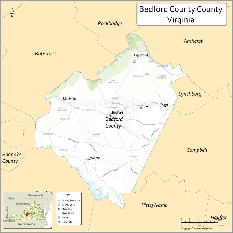
About Bedford County Map, Alabama: The map showing the county boundary, county seat, major cities, highways, water bodies and neighbouring counties.
Related Virginia Links
| Virginia Map | Counties in Virginia | Cities in Virginia |
| Airports in Virginia | Zip Codes in Virginia | Where is Virginia |
| Where is Richmond | Where is Chesapeake | Where is Virginia Beach |
Map of Bedford County, Virginia
Hampton County is a county located in the U.S. state of Virginia. It`s county seat is N/A. As per 2020 census, the population of Hampton County was 137746 and population density of Hampton was square miles. According to the United States Census Bureau, the county has a total area of 52 sq mi (135 km2). Hampton County was established on 1908.
Bedford County Facts
| Continent | North America |
| Country | United States |
| State | Virginia |
| County Seat | Bedford |
| Largest City/Town | Forest |
| Established | 1753 |
| Total Area | 769 sq mi (1,991 sq km) |
| Land Area | 753 sq mi (1,950 sq km) |
| Water Area | 16 sq mi (41 sq km) |
| Population | 79,462 (Census 2020) |
| Population Density | 105 people per sq mi |
| Time Zone | Eastern (EST) |
| Major Highways | US-460, US-221, SR-122 |
| Major Rivers | Roanoke River, James River |
| Neighboring Counties | Amherst County, Campbell County, Pittsylvania County, Franklin County, Roanoke County, Botetourt County |
| Famous For | National D-Day Memorial, Smith Mountain Lake, Blue Ridge Mountains |
| Top Attractions | National D-Day Memorial, Smith Mountain Lake, Peaks of Otter |
| Official Website | Official Website |
About Bedford County, Virginia
Bedford County is located in the south-central part of Virginia in the state of the United States, and was established in 1753. The county seat is the town of Bedford, while Forest is the largest community. The area stretches from the Piedmont region to the Blue Ridge Mountains and is known for its scenic landscapes, lakes, and historical significance.
Cities and Towns in Bedford County, Virginia
| City/Town | Population (Census 2020) | Latitude & Longitude |
|---|---|---|
| Bedford (county seat) | 6,657 | 37.3340°N, 79.5236°W |
| Forest (CDP) | 10,190 | 37.3637°N, 79.2831°W |
| Moneta (CDP) | 1,200 | 37.1815°N, 79.6203°W |
| Huddleston (CDP) | 1,300 | 37.1529°N, 79.5020°W |
| Big Island (CDP) | 300 | 37.5338°N, 79.4009°W |
| Goode (CDP) | 1,700 | 37.3765°N, 79.4053°W |
| Montvale (CDP) | 900 | 37.4007°N, 79.7156°W |
| Thaxton (CDP) | 1,000 | 37.3470°N, 79.6437°W |
| Stewartsville (CDP) | 1,200 | 37.3209°N, 79.7556°W |
| Hardy (CDP) | 1,400 | 37.1405°N, 79.8242°W |
Golf Courses in Bedford County, Virginia
| Golf Course | Location | Latitude & Longitude |
|---|---|---|
| London Downs Golf Club | Forest | 37.3605°N, 79.2730°W |
| Mariners Landing Golf & Country Club | Huddleston | 37.1502°N, 79.4967°W |
| Westlake Golf & Country Club | Hardy | 37.1325°N, 79.7398°W |
| Willow Creek Country Club | Bedford | 37.3345°N, 79.5200°W |
Roads and Highways in Bedford County, Virginia
The county is connected by several major highways that link it to regional cities.
- US-460 – major east-west route connecting Bedford to Lynchburg and Roanoke
- US-221 – runs north-south through the county connecting to Roanoke and Forest
- SR-122 – connects Bedford County to Smith Mountain Lake and surrounding communities
Neighboring Counties of Bedford County
- Amherst County (north)
- Campbell County (east)
- Pittsylvania County (southeast)
- Franklin County (southwest)
- Roanoke County (west)
- Botetourt County (northwest)
Top Attractions in Bedford County, Virginia
The county offers a mix of history, nature, and outdoor recreation.
- National D-Day Memorial – honors Allied forces of World War II
- Smith Mountain Lake – popular for boating, fishing, and lakeside living
- Peaks of Otter – scenic mountains with hiking trails and overlooks
- Blue Ridge Parkway – nearby scenic drive with panoramic views
- Poplar Forest – Thomas Jefferson’s retreat home
- Bedford Museum & Genealogical Library – local history exhibits
- Falling Creek Park – outdoor recreation and trails
Distance from Bedford County to Nearby Cities
- Bedford to Lynchburg, VA – 25 mi (40 km)
- Bedford to Roanoke, VA – 30 mi (48 km)
- Bedford to Charlottesville, VA – 90 mi (145 km)
- Bedford to Richmond, VA – 150 mi (241 km)
- Bedford to Greensboro, NC – 130 mi (209 km)
FAQs about Bedford County
Bedford County is located in south-central Virginia between the Piedmont region and the Blue Ridge Mountains.
The population of Bedford County is 79,462 according to the 2020 Census.
The county is known for the National D-Day Memorial, Smith Mountain Lake, and scenic mountain landscapes.
The main highways include US-460, US-221, and State Route 122.
Yes, Bedford County has several golf courses including Mariners Landing Golf & Country Club and London Downs Golf Club.
- Accomack County Map, VA
- Albemarle County Map, VA
- Alleghany County Map, VA
- Amelia County Map, VA
- Amherst County Map, VA
- Appomattox County Map, VA
- Arlington County Map, VA
- Augusta County Map, VA
- Bath County Map, VA
- Bedford County Map, VA
- Bland County Map, VA
- Botetourt County Map, VA
- Brunswick County Map, VA
- Buchanan County Map, VA
- Buckingham County Map, VA
- Campbell County Map, VA
- Caroline County Map, VA
- Carroll County Map, VA
- Charles City County Map, VA
- Charlotte County Map, VA
- Chesterfield County Map, VA
- Clarke County Map, VA
- Craig County Map, VA
- Culpeper County Map, VA
- Cumberland County Map, VA
- Dickenson County Map, VA
- Dinwiddie County Map, VA
- Essex County Map, VA
- Fairfax County Map, VA
- Fauquier County Map, VA
- Floyd County Map, VA
- Fluvanna County Map, VA
- Franklin County Map, VA
- Frederick County Map, VA
- Giles County Map, VA
- Gloucester County Map, VA
- Goochland County Map, VA
- Grayson County Map, VA
- Greene County Map, VA
- Greensville County Map, VA
- Halifax County Map, VA
- Hanover County Map, VA
- Henrico County Map, VA
- Henry County Map, VA
- Highland County Map, VA
- Isle of Wight County Map, VA
- James City County Map, VA
- King and Queen County Map, VA
- King George County Map, VA
- King William County Map, VA
- Lancaster County Map, VA
- Lee County Map, VA
- Loudoun County Map, VA
- Louisa County Map, VA
- Lunenburg County Map, VA
- Madison County Map, VA
- Mathews County Map, VA
- Mecklenburg County Map, VA
- Middlesex County Map, VA
- Montgomery County Map, VA
- Nelson County Map, VA
- New Kent County Map, VA
- Northampton County Map, VA
- Northumberland County Map, VA
- Nottoway County Map, VA
- Orange County Map, VA
- Page County Map, VA
- Patrick County Map, VA
- Pittsylvania County Map, VA
- Powhatan County Map, VA
- Prince Edward County Map, VA
- Prince George County Map, VA
- Prince William County Map, VA
- Pulaski County Map, VA
- Rappahannock County Map, VA
- Richmond County Map, VA
- Roanoke County Map, VA
- Rockbridge County Map, VA
- Rockingham County Map, VA
- Russell County Map, VA
- Scott County Map, VA
- Shenandoah County Map, VA
- Smyth County Map, VA
- Southampton County Map, VA
- Spotsylvania County Map, VA
- Stafford County Map, VA
- Surry County Map, VA
- Sussex County Map, VA
- Tazewell County Map, VA
- Warren County Map, VA
- Washington County Map, VA
- Westmoreland County Map, VA
- Wise County Map, VA
- Wythe County Map, VA
- York County Map, VA
- Alexandria County Map, VA
- Bristol County Map, VA
- Buena Vista County Map, VA
- Charlottesville County Map, VA
- Chesapeake County Map, VA
- Colonial Heights County Map, VA
- Covington County Map, VA
- Danville County Map, VA
- Emporia County Map, VA
- Fairfax County Map, VA
- Falls Church County Map, VA
- Alabama Counties
- Alaska boroughs
- Arizona Counties
- Arkansas Counties
- California County Map
- Colorado Counties
- Connecticut Counties
- Delaware Counties
- Florida County Map
- Georgia County Map
- Hawaii Counties
- Idaho Counties
- Illinois Counties
- Indiana Counties
- Iowa Counties
- Kansas Counties
- Kentucky Counties
- Louisiana Counties
- Maine Counties
- Maryland Counties
- Massachusetts Counties
- Michigan County Map
- Minnesota Counties
- Mississippi Counties
- Missouri Counties
- Montana Counties
- Nebraska Counties
- Nevada Counties
- New York Counties
- New Hampshire Counties
- New Jersey Counties
- New Mexico Counties
- North Carolina Counties
- North Dakota Counties
- Ohio County Map
- Oklahoma Counties
- Oregon Counties
- Pennsylvania Counties
- Rhode Island Counties
- South Carolina Counties
- South Dakota Counties
- Map of Tennessee
- Texas County Map
- Utah Counties
- Vermont Counties
- Virginia Counties
- Washington Counties
- West Virginia Counties
- Wisconsin Counties
- Wyoming Counties