Map of Bland County - Bland County is a county located in the U.S. state of Virginia. Bland County Map showing cities, highways, important places and water bodies. Get Where is Bland County located in the map, major cities in Bland county, population, areas, and places of interest.
Map of Bland County, Virginia
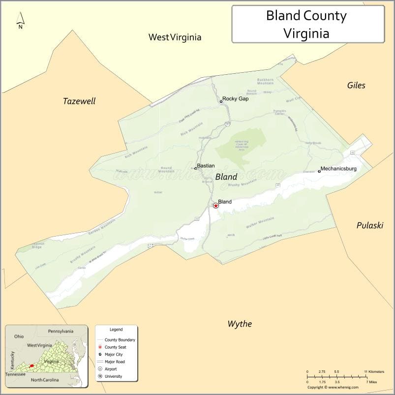
About Bland County Map, Alabama: The map showing the county boundary, county seat, major cities, highways, water bodies and neighbouring counties.
Related Virginia Links
| Virginia Map | Counties in Virginia | Cities in Virginia |
| Airports in Virginia | Zip Codes in Virginia | Where is Virginia |
| Where is Richmond | Where is Chesapeake | Where is Virginia Beach |
Map of Bland County, Virginia
Harrisonburg County is a county located in the U.S. state of Virginia. It`s county seat is N/A. As per 2020 census, the population of Harrisonburg County was 51430 and population density of Harrisonburg was square miles. According to the United States Census Bureau, the county has a total area of 18 sq mi (47 km2). Harrisonburg County was established on 1916.
Bland County Facts
| Continent | North America |
| Country | United States |
| State | Virginia |
| County Seat | Bland |
| Largest City/Town | Bastian |
| Established | 1861 |
| Total Area | 358 sq mi (927 sq km) |
| Land Area | 358 sq mi (927 sq km) |
| Water Area | 0.2 sq mi (0.5 sq km) |
| Population | 6,270 (Census 2020) |
| Population Density | 18 people per sq mi |
| Time Zone | Eastern (EST) |
| Major Highways | I-77, US-52, US-42 |
| Major Rivers | Wolf Creek, New River (nearby) |
| Neighboring Counties | Wythe County, Tazewell County, Giles County, Smyth County |
| Famous For | Rural mountain landscapes, outdoor recreation, Appalachian culture |
| Top Attractions | Big Walker Lookout, Jefferson National Forest, Appalachian Trail |
| Official Website | Official Website |
About Bland County, Virginia
Bland County is located in the southwestern part of Virginia in the state of the United States, and was established in 1861. The county seat is Bland, while Bastian is the largest community. The county lies within the Appalachian Mountains and is known for its quiet rural setting, forested ridges, and scenic outdoor landscapes.
Cities and Towns in Bland County, Virginia
| City/Town | Population (Census 2020) | Latitude & Longitude |
|---|---|---|
| Bland (county seat) | 409 | 37.1021°N, 81.1165°W |
| Bastian | 297 | 37.1507°N, 81.1854°W |
| Ceres (CDP) | 150 | 37.0257°N, 81.3517°W |
| Rocky Gap (CDP) | 300 | 37.2076°N, 81.1484°W |
| Hollybrook (CDP) | 100 | 37.1245°N, 81.0812°W |
| Sharon Springs (CDP) | 120 | 37.1810°N, 81.0905°W |
| Seddon (CDP) | 80 | 37.0653°N, 81.2058°W |
Golf Courses in Bland County, Virginia
| Golf Course | Location | Latitude & Longitude |
|---|---|---|
| None (no major golf courses within county limits) | N/A | N/A |
| Fincastle Country Club (nearby) | Tazewell County | 37.1115°N, 81.4910°W |
Roads and Highways in Bland County, Virginia
The county is served by major mountain highways that connect it to surrounding regions.
- I-77 – major north-south interstate connecting Bland County to West Virginia and North Carolina
- US-52 – runs parallel to I-77 through the county
- US-42 – connects rural communities within the county
Neighboring Counties of Bland County
- Giles County (north)
- Wythe County (east)
- Smyth County (south)
- Tazewell County (west)
Top Attractions in Bland County, Virginia
The county offers peaceful natural settings and scenic mountain views.
- Big Walker Lookout – panoramic views of the Appalachian Mountains
- Jefferson National Forest – hiking, camping, and wildlife viewing
- Appalachian Trail – passes through nearby mountain areas
- Wolf Creek Indian Village & Museum – local cultural and historical site
- Burke’s Garden (nearby) – scenic valley often called “God’s Thumbprint”
- East River Mountain Overlook – scenic drive and viewpoint
Distance from Bland County to Nearby Cities
- Bland to Wytheville, VA – 25 mi (40 km)
- Bland to Bluefield, WV – 20 mi (32 km)
- Bland to Roanoke, VA – 90 mi (145 km)
- Bland to Bristol, VA – 80 mi (129 km)
- Bland to Charleston, WV – 150 mi (241 km)
FAQs about Bland County
Bland County is located in southwestern Virginia within the Appalachian Mountain region.
The population of Bland County is 6,270 according to the 2020 Census.
The county is known for its rural landscapes, mountain scenery, and outdoor recreation opportunities.
The main highways include Interstate 77, US-52, and US-42.
No major golf courses are located within Bland County, but nearby counties offer golf facilities.
- Accomack County Map, VA
- Albemarle County Map, VA
- Alleghany County Map, VA
- Amelia County Map, VA
- Amherst County Map, VA
- Appomattox County Map, VA
- Arlington County Map, VA
- Augusta County Map, VA
- Bath County Map, VA
- Bedford County Map, VA
- Bland County Map, VA
- Botetourt County Map, VA
- Brunswick County Map, VA
- Buchanan County Map, VA
- Buckingham County Map, VA
- Campbell County Map, VA
- Caroline County Map, VA
- Carroll County Map, VA
- Charles City County Map, VA
- Charlotte County Map, VA
- Chesterfield County Map, VA
- Clarke County Map, VA
- Craig County Map, VA
- Culpeper County Map, VA
- Cumberland County Map, VA
- Dickenson County Map, VA
- Dinwiddie County Map, VA
- Essex County Map, VA
- Fairfax County Map, VA
- Fauquier County Map, VA
- Floyd County Map, VA
- Fluvanna County Map, VA
- Franklin County Map, VA
- Frederick County Map, VA
- Giles County Map, VA
- Gloucester County Map, VA
- Goochland County Map, VA
- Grayson County Map, VA
- Greene County Map, VA
- Greensville County Map, VA
- Halifax County Map, VA
- Hanover County Map, VA
- Henrico County Map, VA
- Henry County Map, VA
- Highland County Map, VA
- Isle of Wight County Map, VA
- James City County Map, VA
- King and Queen County Map, VA
- King George County Map, VA
- King William County Map, VA
- Lancaster County Map, VA
- Lee County Map, VA
- Loudoun County Map, VA
- Louisa County Map, VA
- Lunenburg County Map, VA
- Madison County Map, VA
- Mathews County Map, VA
- Mecklenburg County Map, VA
- Middlesex County Map, VA
- Montgomery County Map, VA
- Nelson County Map, VA
- New Kent County Map, VA
- Northampton County Map, VA
- Northumberland County Map, VA
- Nottoway County Map, VA
- Orange County Map, VA
- Page County Map, VA
- Patrick County Map, VA
- Pittsylvania County Map, VA
- Powhatan County Map, VA
- Prince Edward County Map, VA
- Prince George County Map, VA
- Prince William County Map, VA
- Pulaski County Map, VA
- Rappahannock County Map, VA
- Richmond County Map, VA
- Roanoke County Map, VA
- Rockbridge County Map, VA
- Rockingham County Map, VA
- Russell County Map, VA
- Scott County Map, VA
- Shenandoah County Map, VA
- Smyth County Map, VA
- Southampton County Map, VA
- Spotsylvania County Map, VA
- Stafford County Map, VA
- Surry County Map, VA
- Sussex County Map, VA
- Tazewell County Map, VA
- Warren County Map, VA
- Washington County Map, VA
- Westmoreland County Map, VA
- Wise County Map, VA
- Wythe County Map, VA
- York County Map, VA
- Alexandria County Map, VA
- Bristol County Map, VA
- Buena Vista County Map, VA
- Charlottesville County Map, VA
- Chesapeake County Map, VA
- Colonial Heights County Map, VA
- Covington County Map, VA
- Danville County Map, VA
- Emporia County Map, VA
- Fairfax County Map, VA
- Falls Church County Map, VA
- Alabama Counties
- Alaska boroughs
- Arizona Counties
- Arkansas Counties
- California County Map
- Colorado Counties
- Connecticut Counties
- Delaware Counties
- Florida County Map
- Georgia County Map
- Hawaii Counties
- Idaho Counties
- Illinois Counties
- Indiana Counties
- Iowa Counties
- Kansas Counties
- Kentucky Counties
- Louisiana Counties
- Maine Counties
- Maryland Counties
- Massachusetts Counties
- Michigan County Map
- Minnesota Counties
- Mississippi Counties
- Missouri Counties
- Montana Counties
- Nebraska Counties
- Nevada Counties
- New York Counties
- New Hampshire Counties
- New Jersey Counties
- New Mexico Counties
- North Carolina Counties
- North Dakota Counties
- Ohio County Map
- Oklahoma Counties
- Oregon Counties
- Pennsylvania Counties
- Rhode Island Counties
- South Carolina Counties
- South Dakota Counties
- Map of Tennessee
- Texas County Map
- Utah Counties
- Vermont Counties
- Virginia Counties
- Washington Counties
- West Virginia Counties
- Wisconsin Counties
- Wyoming Counties