Map of Fauquier County - Fauquier County is a county located in the U.S. state of Virginia. Fauquier County Map showing cities, highways, important places and water bodies. Get Where is Fauquier County located in the map, major cities in Fauquier county, population, areas, and places of interest.
Map of Fauquier County, Virginia
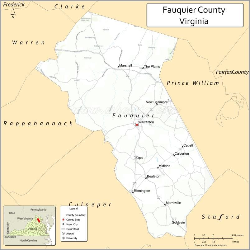
About Fauquier County Map, Alabama: The map showing the county boundary, county seat, major cities, highways, water bodies and neighbouring counties.
Related Virginia Links
| Virginia Map | Counties in Virginia | Cities in Virginia |
| Airports in Virginia | Zip Codes in Virginia | Where is Virginia |
| Where is Richmond | Where is Chesapeake | Where is Virginia Beach |
Map of Fauquier County, Virginia
Virginia Beach County is a county located in the U.S. state of Virginia. It`s county seat is N/A. As per 2020 census, the population of Virginia Beach County was 457672 and population density of Virginia Beach was square miles. According to the United States Census Bureau, the county has a total area of 248 sq mi (642 km2). Virginia Beach County was established on 1963.
Fauquier County Facts
| Continent | North America |
| Country | United States |
| State | Virginia |
| County Seat | Warrenton |
| Largest City/Town | Warrenton |
| Established | 1759 |
| Total Area | 651 sq mi (1,686 sq km) |
| Land Area | 647 sq mi (1,676 sq km) |
| Water Area | 4 sq mi (10 sq km) |
| Population | 76,457 (Census 2020) |
| Population Density | 118 people per sq mi |
| Time Zone | Eastern (EST) |
| Major Highways | US-15, US-17, US-29, US-50 |
| Major Rivers | Rappahannock River |
| Neighboring Counties | Loudoun County, Prince William County, Stafford County, Culpeper County, Rappahannock County |
| Famous For | Horse country, wineries, historic countryside |
| Top Attractions | Sky Meadows State Park, wineries, historic Warrenton |
| Official Website | Official Website |
About Fauquier County, Virginia
Fauquier County is located in northern Virginia in the state of the United States, and was established in 1759. The county seat is Warrenton, which is also the largest town. The county lies in the Piedmont region at the foothills of the Blue Ridge Mountains and is known for its scenic landscapes, equestrian culture, and vineyards.
Cities and Towns in Fauquier County, Virginia
| City/Town | Population (Census 2020) | Latitude & Longitude |
|---|---|---|
| Warrenton (county seat) | 10,057 | 38.7135°N, 77.7953°W |
| The Plains (town) | 266 | 38.8621°N, 77.7733°W |
| Remington (town) | 623 | 38.5335°N, 77.8075°W |
| Bealeton (CDP) | 5,800 | 38.5732°N, 77.7630°W |
| Marshall (CDP) | 2,000 | 38.8646°N, 77.8586°W |
| Catlett (CDP) | 300 | 38.6357°N, 77.6333°W |
| New Baltimore (CDP) | 8,000 | 38.7800°N, 77.6900°W |
Golf Courses in Fauquier County, Virginia
| Golf Course | Location | Latitude & Longitude |
|---|---|---|
| Fauquier Springs Country Club | Warrenton | 38.7250°N, 77.7900°W |
| Westfields Golf Club (nearby) | Clifton area | 38.8430°N, 77.4300°W |
Roads and Highways in Fauquier County, Virginia
The county is served by major highways connecting Northern Virginia to central regions.
- US-15 – north-south route through the county
- US-17 – connects to Fredericksburg and northern Virginia
- US-29 – major corridor linking to Washington, D.C. and Charlottesville
- US-50 – east-west route through the county
Neighboring Counties of Fauquier County
- Loudoun County (north)
- Prince William County (east)
- Stafford County (southeast)
- Culpeper County (southwest)
- Rappahannock County (west)
Top Attractions in Fauquier County, Virginia
The county offers scenic countryside and historic attractions.
- Sky Meadows State Park – hiking trails and scenic mountain views
- Great Meadow Event Park – equestrian events and festivals
- Warrenton Historic District – shops, dining, and historic buildings
- Local wineries – wine tasting and vineyard tours
- Blue Ridge Mountains (nearby) – outdoor recreation and views
- Rappahannock River – fishing and nature activities
Distance from Fauquier County to Nearby Cities
- Warrenton to Washington, DC – 45 mi (72 km)
- Warrenton to Fairfax, VA – 35 mi (56 km)
- Warrenton to Fredericksburg, VA – 40 mi (64 km)
- Warrenton to Charlottesville, VA – 70 mi (113 km)
- Warrenton to Richmond, VA – 110 mi (177 km)
FAQs about Fauquier County
Fauquier County is located in northern Virginia in the Piedmont region near the Blue Ridge Mountains.
The population of Fauquier County is 76,457 according to the 2020 Census.
The county is known for its horse farms, wineries, and scenic countryside.
The main highways include US-15, US-17, US-29, and US-50.
Yes, Fauquier County has golf courses such as Fauquier Springs Country Club.
- Accomack County Map, VA
- Albemarle County Map, VA
- Alleghany County Map, VA
- Amelia County Map, VA
- Amherst County Map, VA
- Appomattox County Map, VA
- Arlington County Map, VA
- Augusta County Map, VA
- Bath County Map, VA
- Bedford County Map, VA
- Bland County Map, VA
- Botetourt County Map, VA
- Brunswick County Map, VA
- Buchanan County Map, VA
- Buckingham County Map, VA
- Campbell County Map, VA
- Caroline County Map, VA
- Carroll County Map, VA
- Charles City County Map, VA
- Charlotte County Map, VA
- Chesterfield County Map, VA
- Clarke County Map, VA
- Craig County Map, VA
- Culpeper County Map, VA
- Cumberland County Map, VA
- Dickenson County Map, VA
- Dinwiddie County Map, VA
- Essex County Map, VA
- Fairfax County Map, VA
- Fauquier County Map, VA
- Floyd County Map, VA
- Fluvanna County Map, VA
- Franklin County Map, VA
- Frederick County Map, VA
- Giles County Map, VA
- Gloucester County Map, VA
- Goochland County Map, VA
- Grayson County Map, VA
- Greene County Map, VA
- Greensville County Map, VA
- Halifax County Map, VA
- Hanover County Map, VA
- Henrico County Map, VA
- Henry County Map, VA
- Highland County Map, VA
- Isle of Wight County Map, VA
- James City County Map, VA
- King and Queen County Map, VA
- King George County Map, VA
- King William County Map, VA
- Lancaster County Map, VA
- Lee County Map, VA
- Loudoun County Map, VA
- Louisa County Map, VA
- Lunenburg County Map, VA
- Madison County Map, VA
- Mathews County Map, VA
- Mecklenburg County Map, VA
- Middlesex County Map, VA
- Montgomery County Map, VA
- Nelson County Map, VA
- New Kent County Map, VA
- Northampton County Map, VA
- Northumberland County Map, VA
- Nottoway County Map, VA
- Orange County Map, VA
- Page County Map, VA
- Patrick County Map, VA
- Pittsylvania County Map, VA
- Powhatan County Map, VA
- Prince Edward County Map, VA
- Prince George County Map, VA
- Prince William County Map, VA
- Pulaski County Map, VA
- Rappahannock County Map, VA
- Richmond County Map, VA
- Roanoke County Map, VA
- Rockbridge County Map, VA
- Rockingham County Map, VA
- Russell County Map, VA
- Scott County Map, VA
- Shenandoah County Map, VA
- Smyth County Map, VA
- Southampton County Map, VA
- Spotsylvania County Map, VA
- Stafford County Map, VA
- Surry County Map, VA
- Sussex County Map, VA
- Tazewell County Map, VA
- Warren County Map, VA
- Washington County Map, VA
- Westmoreland County Map, VA
- Wise County Map, VA
- Wythe County Map, VA
- York County Map, VA
- Alexandria County Map, VA
- Bristol County Map, VA
- Buena Vista County Map, VA
- Charlottesville County Map, VA
- Chesapeake County Map, VA
- Colonial Heights County Map, VA
- Covington County Map, VA
- Danville County Map, VA
- Emporia County Map, VA
- Fairfax County Map, VA
- Falls Church County Map, VA
- Alabama Counties
- Alaska boroughs
- Arizona Counties
- Arkansas Counties
- California County Map
- Colorado Counties
- Connecticut Counties
- Delaware Counties
- Florida County Map
- Georgia County Map
- Hawaii Counties
- Idaho Counties
- Illinois Counties
- Indiana Counties
- Iowa Counties
- Kansas Counties
- Kentucky Counties
- Louisiana Counties
- Maine Counties
- Maryland Counties
- Massachusetts Counties
- Michigan County Map
- Minnesota Counties
- Mississippi Counties
- Missouri Counties
- Montana Counties
- Nebraska Counties
- Nevada Counties
- New York Counties
- New Hampshire Counties
- New Jersey Counties
- New Mexico Counties
- North Carolina Counties
- North Dakota Counties
- Ohio County Map
- Oklahoma Counties
- Oregon Counties
- Pennsylvania Counties
- Rhode Island Counties
- South Carolina Counties
- South Dakota Counties
- Map of Tennessee
- Texas County Map
- Utah Counties
- Vermont Counties
- Virginia Counties
- Washington Counties
- West Virginia Counties
- Wisconsin Counties
- Wyoming Counties