Map of Mecklenburg County - Mecklenburg County is a county located in the U.S. state of Virginia. Mecklenburg County Map showing cities, highways, important places and water bodies. Get Where is Mecklenburg County located in the map, major cities in Mecklenburg county, population, areas, and places of interest.
Map of Mecklenburg County, Virginia
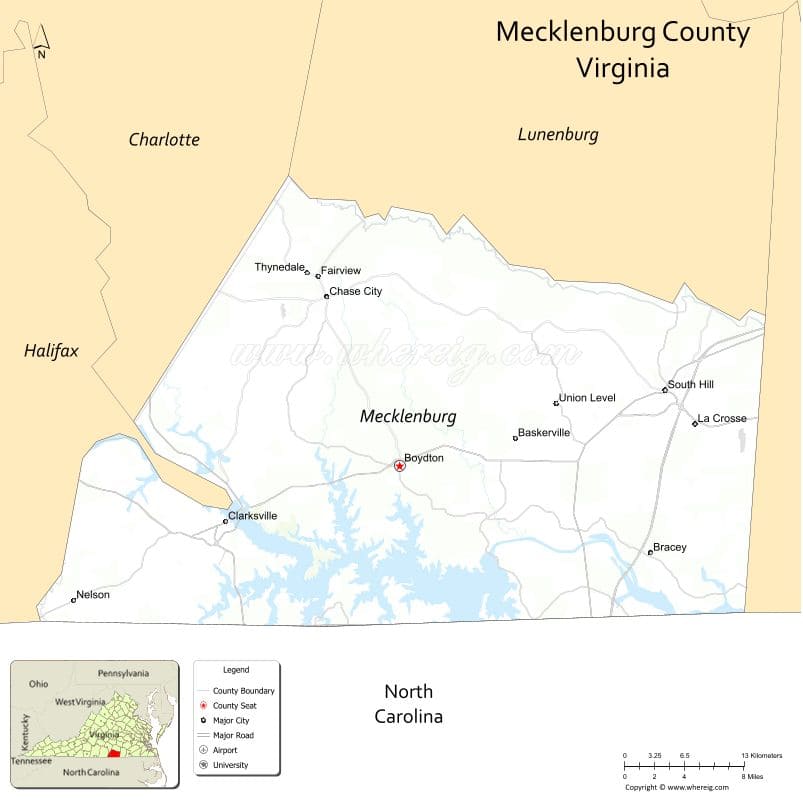
About Mecklenburg County Map, Alabama: The map showing the county boundary, county seat, major cities, highways, water bodies and neighbouring counties.
Related Virginia Links
| Virginia Map | Counties in Virginia | Cities in Virginia |
| Airports in Virginia | Zip Codes in Virginia | Where is Virginia |
| Where is Richmond | Where is Chesapeake | Where is Virginia Beach |
Map of Mecklenburg County, Virginia
San Juan County is a county located in the U.S. state of Washington. It`s county seat is Friday Harbor. As per 2020 census, the population of San Juan County was 17788 and population density of San Juan was square miles. According to the United States Census Bureau, the county has a total area of 174 sq mi (451 km2). San Juan County was established on 1873.
Mecklenburg County Facts
| Continent | North America |
| Country | United States |
| State | Virginia |
| County Seat | Boydton |
| Largest City/Town | South Hill |
| Established | 1765 |
| Total Area | 679 sq mi (1,758 sq km) |
| Land Area | 625 sq mi (1,619 sq km) |
| Water Area | 54 sq mi (140 sq km) |
| Population | 30,319 (Census 2020) |
| Population Density | 49 people per sq mi |
| Time Zone | Eastern (EST) |
| Major Highways | I-85, US-58, US-1, US-15 |
| Major Rivers | Roanoke River (John H. Kerr Reservoir/Buggs Island Lake) |
| Neighboring Counties | Brunswick County, Lunenburg County, Charlotte County, Halifax County, Warren County (NC), Vance County (NC), Granville County (NC) |
| Famous For | Lake Gaston, Kerr Lake, fishing and recreation |
| Top Attractions | Kerr Lake State Recreation Area, Occoneechee State Park, Lake Gaston |
| Official Website | Official Website |
About Mecklenburg County, Virginia
Mecklenburg County is located in the south-central part of Virginia in the state of the United States, and was established in 1765. The county seat is Boydton, while South Hill is the largest town. The county lies along the North Carolina border and is known for its large lakes, outdoor recreation, and fishing opportunities.
Cities and Towns in Mecklenburg County, Virginia
| City/Town | Population (Census 2020) | Latitude & Longitude |
|---|---|---|
| South Hill (town) | 4,700 | 36.7200°N, 78.1300°W |
| Clarksville (town) | 1,200 | 36.6200°N, 78.5600°W |
| Chase City (town) | 2,000 | 36.8000°N, 78.4600°W |
| Boydton (county seat, town) | 400 | 36.6600°N, 78.3800°W |
| La Crosse (town) | 700 | 36.6900°N, 78.1000°W |
| Bracey (CDP) | 1,500 | 36.6000°N, 78.1500°W |
Golf Courses in Mecklenburg County, Virginia
| Golf Course | Location | Latitude & Longitude |
|---|---|---|
| Kinderton Country Club | Clarksville area | 36.6300°N, 78.5500°W |
| Lake Gaston Golf Club | Bracey area | 36.6000°N, 78.1000°W |
Roads and Highways in Mecklenburg County, Virginia
The county is a transportation hub in southern Virginia.
- I-85 – major interstate connecting Richmond and North Carolina
- US-58 – east-west route across southern Virginia
- US-1 – north-south highway
- US-15 – connects to South Hill and beyond
Neighboring Counties of Mecklenburg County
- Lunenburg County (north)
- Charlotte County (northwest)
- Halifax County (west)
- Brunswick County (east)
- Warren County, North Carolina (south)
- Vance County, North Carolina (south)
- Granville County, North Carolina (south)
Top Attractions in Mecklenburg County, Virginia
The county is known for its lakes and outdoor activities.
- Kerr Lake (Buggs Island Lake) – boating, fishing, and camping
- Lake Gaston – popular vacation and recreation destination
- Occoneechee State Park – hiking, camping, and lake views
- Clarksville Historic District – charming lakeside town
- John H. Kerr Dam – scenic views and engineering landmark
Distance from Mecklenburg County to Nearby Cities
- South Hill to Richmond, VA – 85 mi (137 km)
- South Hill to Raleigh, NC – 70 mi (113 km)
- South Hill to Petersburg, VA – 60 mi (97 km)
- South Hill to Durham, NC – 75 mi (121 km)
- South Hill to Washington, DC – 180 mi (290 km)
FAQs about Mecklenburg County
Mecklenburg County is located in south-central Virginia along the North Carolina border.
The population of Mecklenburg County is 30,319 according to the 2020 Census.
The county is known for Lake Gaston, Kerr Lake, and outdoor recreation activities.
The main highways include I-85, US-58, US-1, and US-15.
Yes, Mecklenburg County has golf courses such as Kinderton Country Club and Lake Gaston Golf Club.
- Accomack County Map, VA
- Albemarle County Map, VA
- Alleghany County Map, VA
- Amelia County Map, VA
- Amherst County Map, VA
- Appomattox County Map, VA
- Arlington County Map, VA
- Augusta County Map, VA
- Bath County Map, VA
- Bedford County Map, VA
- Bland County Map, VA
- Botetourt County Map, VA
- Brunswick County Map, VA
- Buchanan County Map, VA
- Buckingham County Map, VA
- Campbell County Map, VA
- Caroline County Map, VA
- Carroll County Map, VA
- Charles City County Map, VA
- Charlotte County Map, VA
- Chesterfield County Map, VA
- Clarke County Map, VA
- Craig County Map, VA
- Culpeper County Map, VA
- Cumberland County Map, VA
- Dickenson County Map, VA
- Dinwiddie County Map, VA
- Essex County Map, VA
- Fairfax County Map, VA
- Fauquier County Map, VA
- Floyd County Map, VA
- Fluvanna County Map, VA
- Franklin County Map, VA
- Frederick County Map, VA
- Giles County Map, VA
- Gloucester County Map, VA
- Goochland County Map, VA
- Grayson County Map, VA
- Greene County Map, VA
- Greensville County Map, VA
- Halifax County Map, VA
- Hanover County Map, VA
- Henrico County Map, VA
- Henry County Map, VA
- Highland County Map, VA
- Isle of Wight County Map, VA
- James City County Map, VA
- King and Queen County Map, VA
- King George County Map, VA
- King William County Map, VA
- Lancaster County Map, VA
- Lee County Map, VA
- Loudoun County Map, VA
- Louisa County Map, VA
- Lunenburg County Map, VA
- Madison County Map, VA
- Mathews County Map, VA
- Mecklenburg County Map, VA
- Middlesex County Map, VA
- Montgomery County Map, VA
- Nelson County Map, VA
- New Kent County Map, VA
- Northampton County Map, VA
- Northumberland County Map, VA
- Nottoway County Map, VA
- Orange County Map, VA
- Page County Map, VA
- Patrick County Map, VA
- Pittsylvania County Map, VA
- Powhatan County Map, VA
- Prince Edward County Map, VA
- Prince George County Map, VA
- Prince William County Map, VA
- Pulaski County Map, VA
- Rappahannock County Map, VA
- Richmond County Map, VA
- Roanoke County Map, VA
- Rockbridge County Map, VA
- Rockingham County Map, VA
- Russell County Map, VA
- Scott County Map, VA
- Shenandoah County Map, VA
- Smyth County Map, VA
- Southampton County Map, VA
- Spotsylvania County Map, VA
- Stafford County Map, VA
- Surry County Map, VA
- Sussex County Map, VA
- Tazewell County Map, VA
- Warren County Map, VA
- Washington County Map, VA
- Westmoreland County Map, VA
- Wise County Map, VA
- Wythe County Map, VA
- York County Map, VA
- Alexandria County Map, VA
- Bristol County Map, VA
- Buena Vista County Map, VA
- Charlottesville County Map, VA
- Chesapeake County Map, VA
- Colonial Heights County Map, VA
- Covington County Map, VA
- Danville County Map, VA
- Emporia County Map, VA
- Fairfax County Map, VA
- Falls Church County Map, VA
- Alabama Counties
- Alaska boroughs
- Arizona Counties
- Arkansas Counties
- California County Map
- Colorado Counties
- Connecticut Counties
- Delaware Counties
- Florida County Map
- Georgia County Map
- Hawaii Counties
- Idaho Counties
- Illinois Counties
- Indiana Counties
- Iowa Counties
- Kansas Counties
- Kentucky Counties
- Louisiana Counties
- Maine Counties
- Maryland Counties
- Massachusetts Counties
- Michigan County Map
- Minnesota Counties
- Mississippi Counties
- Missouri Counties
- Montana Counties
- Nebraska Counties
- Nevada Counties
- New York Counties
- New Hampshire Counties
- New Jersey Counties
- New Mexico Counties
- North Carolina Counties
- North Dakota Counties
- Ohio County Map
- Oklahoma Counties
- Oregon Counties
- Pennsylvania Counties
- Rhode Island Counties
- South Carolina Counties
- South Dakota Counties
- Map of Tennessee
- Texas County Map
- Utah Counties
- Vermont Counties
- Virginia Counties
- Washington Counties
- West Virginia Counties
- Wisconsin Counties
- Wyoming Counties