Map of Alexandria County - Alexandria County is a county located in the U.S. state of Virginia. Alexandria County Map showing cities, highways, important places and water bodies. Get Where is Alexandria County located in the map, major cities in Alexandria county, population, areas, and places of interest.
Map of Alexandria County, Virginia
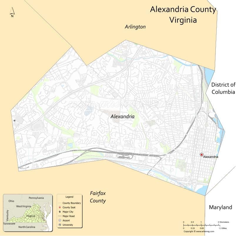
About Alexandria County Map, Alabama: The map showing the county boundary, county seat, major cities, highways, water bodies and neighbouring counties.
Related Virginia Links
| Virginia Map | Counties in Virginia | Cities in Virginia |
| Airports in Virginia | Zip Codes in Virginia | Where is Virginia |
| Where is Richmond | Where is Chesapeake | Where is Virginia Beach |
Map of Alexandria County, Virginia
McDowell County is a county located in the U.S. state of West Virginia. It`s county seat is Welch. As per 2020 census, the population of McDowell County was 18363 and population density of McDowell was square miles. According to the United States Census Bureau, the county has a total area of 535 sq mi (1,386 km2). McDowell County was established on 1858.
Alexandria County Facts
| Continent | North America |
| Country | United States |
| State | Virginia |
| County Seat | Alexandria |
| Largest City/Town | Alexandria |
| Established | 1742 |
| Total Area | 351 sq mi (909 sq km) |
| Land Area | 343 sq mi (888 sq km) |
| Water Area | 8 sq mi (21 sq km) |
| Population | Unorganized / historical county |
| Population Density | N/A |
| Time Zone | Eastern (EST) |
| Major Highways | US-1, I-395, I-495 |
| Major Rivers | Potomac River |
| Neighboring Counties | Fairfax County (VA), Prince George's County (MD), Washington, DC |
| Famous For | Historic origins of Arlington County, proximity to Washington, DC |
| Top Attractions | Old Town Alexandria, Arlington National Cemetery, Pentagon area |
| Official Website | Official Website |
About Alexandria County, Virginia
Alexandria County was located in the northern part of Virginia along the Potomac River, in the state of the United States, and was established in 1742. The county seat was Alexandria, which later became an independent city. In 1920, Alexandria County was officially renamed Arlington County, and today it no longer exists under its original name but remains historically significant.
Cities and Towns in Alexandria County, Virginia
| City/Town | Population (Census 2020) | Latitude & Longitude |
|---|---|---|
| Alexandria (county seat, now independent city) | 159,467 | 38.8048°N, 77.0469°W |
| Arlington (historical area, now Arlington County) | 238,643 | 38.8816°N, 77.0910°W |
Golf Courses in Alexandria County, Virginia
| Golf Course | Location | Latitude & Longitude |
|---|---|---|
| Army Navy Country Club | Arlington | 38.8700°N, 77.0800°W |
| Washington Golf & Country Club | Arlington | 38.9100°N, 77.1200°W |
Roads and Highways in Alexandria County, Virginia
The historical county area is now served by major highways connecting Northern Virginia and Washington, DC.
- I-395 – connects Arlington and Alexandria to Washington, DC
- I-495 – Capital Beltway surrounding Washington metropolitan area
- US-1 – runs along the Potomac River through Alexandria
Neighboring Counties of Alexandria County
- Fairfax County (south and west)
- Prince George's County, Maryland (east)
- Washington, DC (north)
Top Attractions in Alexandria County, Virginia
The former county area includes many historic and national landmarks.
- Old Town Alexandria – historic district with colonial architecture and waterfront views
- Arlington National Cemetery – burial site of U.S. military personnel
- The Pentagon – headquarters of the U.S. Department of Defense
- Mount Vernon – George Washington’s estate nearby
- Potomac River Waterfront – scenic walking and recreation areas
- Air Force Memorial – iconic monument overlooking Arlington
- Theodore Roosevelt Island – natural preserve and memorial park
Distance from Alexandria County to Nearby Cities
- Alexandria to Washington, DC – 8 mi (13 km)
- Alexandria to Fairfax, VA – 20 mi (32 km)
- Alexandria to Bethesda, MD – 15 mi (24 km)
- Alexandria to Richmond, VA – 105 mi (169 km)
- Alexandria to Baltimore, MD – 40 mi (64 km)
FAQs about Alexandria County
Alexandria County was located in northern Virginia along the Potomac River near Washington, DC.
No, Alexandria County was renamed Arlington County in 1920 and no longer exists under its original name.
It is known for its historical role in forming Arlington County and its proximity to major national landmarks.
The area is served by major highways including I-395, I-495, and US-1.
Yes, notable golf courses include Army Navy Country Club and Washington Golf & Country Club.
- Accomack County Map, VA
- Albemarle County Map, VA
- Alleghany County Map, VA
- Amelia County Map, VA
- Amherst County Map, VA
- Appomattox County Map, VA
- Arlington County Map, VA
- Augusta County Map, VA
- Bath County Map, VA
- Bedford County Map, VA
- Bland County Map, VA
- Botetourt County Map, VA
- Brunswick County Map, VA
- Buchanan County Map, VA
- Buckingham County Map, VA
- Campbell County Map, VA
- Caroline County Map, VA
- Carroll County Map, VA
- Charles City County Map, VA
- Charlotte County Map, VA
- Chesterfield County Map, VA
- Clarke County Map, VA
- Craig County Map, VA
- Culpeper County Map, VA
- Cumberland County Map, VA
- Dickenson County Map, VA
- Dinwiddie County Map, VA
- Essex County Map, VA
- Fairfax County Map, VA
- Fauquier County Map, VA
- Floyd County Map, VA
- Fluvanna County Map, VA
- Franklin County Map, VA
- Frederick County Map, VA
- Giles County Map, VA
- Gloucester County Map, VA
- Goochland County Map, VA
- Grayson County Map, VA
- Greene County Map, VA
- Greensville County Map, VA
- Halifax County Map, VA
- Hanover County Map, VA
- Henrico County Map, VA
- Henry County Map, VA
- Highland County Map, VA
- Isle of Wight County Map, VA
- James City County Map, VA
- King and Queen County Map, VA
- King George County Map, VA
- King William County Map, VA
- Lancaster County Map, VA
- Lee County Map, VA
- Loudoun County Map, VA
- Louisa County Map, VA
- Lunenburg County Map, VA
- Madison County Map, VA
- Mathews County Map, VA
- Mecklenburg County Map, VA
- Middlesex County Map, VA
- Montgomery County Map, VA
- Nelson County Map, VA
- New Kent County Map, VA
- Northampton County Map, VA
- Northumberland County Map, VA
- Nottoway County Map, VA
- Orange County Map, VA
- Page County Map, VA
- Patrick County Map, VA
- Pittsylvania County Map, VA
- Powhatan County Map, VA
- Prince Edward County Map, VA
- Prince George County Map, VA
- Prince William County Map, VA
- Pulaski County Map, VA
- Rappahannock County Map, VA
- Richmond County Map, VA
- Roanoke County Map, VA
- Rockbridge County Map, VA
- Rockingham County Map, VA
- Russell County Map, VA
- Scott County Map, VA
- Shenandoah County Map, VA
- Smyth County Map, VA
- Southampton County Map, VA
- Spotsylvania County Map, VA
- Stafford County Map, VA
- Surry County Map, VA
- Sussex County Map, VA
- Tazewell County Map, VA
- Warren County Map, VA
- Washington County Map, VA
- Westmoreland County Map, VA
- Wise County Map, VA
- Wythe County Map, VA
- York County Map, VA
- Alexandria County Map, VA
- Bristol County Map, VA
- Buena Vista County Map, VA
- Charlottesville County Map, VA
- Chesapeake County Map, VA
- Colonial Heights County Map, VA
- Covington County Map, VA
- Danville County Map, VA
- Emporia County Map, VA
- Fairfax County Map, VA
- Falls Church County Map, VA
- Alabama Counties
- Alaska boroughs
- Arizona Counties
- Arkansas Counties
- California County Map
- Colorado Counties
- Connecticut Counties
- Delaware Counties
- Florida County Map
- Georgia County Map
- Hawaii Counties
- Idaho Counties
- Illinois Counties
- Indiana Counties
- Iowa Counties
- Kansas Counties
- Kentucky Counties
- Louisiana Counties
- Maine Counties
- Maryland Counties
- Massachusetts Counties
- Michigan County Map
- Minnesota Counties
- Mississippi Counties
- Missouri Counties
- Montana Counties
- Nebraska Counties
- Nevada Counties
- New York Counties
- New Hampshire Counties
- New Jersey Counties
- New Mexico Counties
- North Carolina Counties
- North Dakota Counties
- Ohio County Map
- Oklahoma Counties
- Oregon Counties
- Pennsylvania Counties
- Rhode Island Counties
- South Carolina Counties
- South Dakota Counties
- Map of Tennessee
- Texas County Map
- Utah Counties
- Vermont Counties
- Virginia Counties
- Washington Counties
- West Virginia Counties
- Wisconsin Counties
- Wyoming Counties