Map of Bath County - Bath County is a county located in the U.S. state of Virginia. Bath County Map showing cities, highways, important places and water bodies. Get Where is Bath County located in the map, major cities in Bath county, population, areas, and places of interest.
Map of Bath County, Virginia
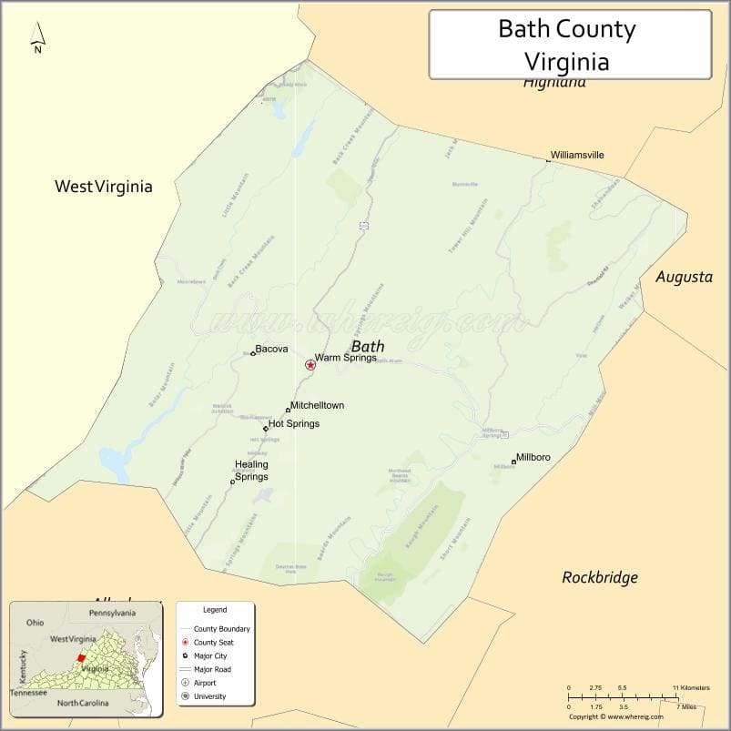
About Bath County Map, Alabama: The map showing the county boundary, county seat, major cities, highways, water bodies and neighbouring counties.
Related Virginia Links
| Virginia Map | Counties in Virginia | Cities in Virginia |
| Airports in Virginia | Zip Codes in Virginia | Where is Virginia |
| Where is Richmond | Where is Chesapeake | Where is Virginia Beach |
Map of Bath County, Virginia
Galax County is a county located in the U.S. state of Virginia. It`s county seat is N/A. As per 2020 census, the population of Galax County was 6660 and population density of Galax was square miles. According to the United States Census Bureau, the county has a total area of 8 sq mi (21 km2). Galax County was established on 1953.
Bath County Facts
| Continent | North America |
| Country | United States |
| State | Virginia |
| County Seat | Warm Springs |
| Largest City/Town | Hot Springs |
| Established | 1790 |
| Total Area | 535 sq mi (1,386 sq km) |
| Land Area | 529 sq mi (1,370 sq km) |
| Water Area | 6 sq mi (16 sq km) |
| Population | 4,089 (Census 2020) |
| Population Density | 8 people per sq mi |
| Time Zone | Eastern (EST) |
| Major Highways | US-220, US-60, SR-39 |
| Major Rivers | Jackson River, Cowpasture River |
| Neighboring Counties | Alleghany County, Augusta County, Highland County, Rockbridge County, Greenbrier County (WV) |
| Famous For | Natural hot springs, mountain scenery, luxury resorts |
| Top Attractions | The Omni Homestead Resort, Warm Springs Pools, George Washington National Forest |
| Official Website | Official Website |
About Bath County, Virginia
Bath County is located in the western part of Virginia in the state of the United States, and was established in 1790. The county seat is Warm Springs, while Hot Springs is the largest community. The area lies within the Allegheny Mountains and is known for its natural hot springs, scenic valleys, and quiet rural atmosphere.
Cities and Towns in Bath County, Virginia
| City/Town | Population (Census 2020) | Latitude & Longitude |
|---|---|---|
| Warm Springs (county seat, CDP) | 123 | 38.0479°N, 79.7803°W |
| Hot Springs (CDP) | 738 | 38.0215°N, 79.8317°W |
| Millboro (CDP) | 200 | 38.0707°N, 79.6808°W |
| Burnsville (CDP) | 150 | 38.0902°N, 79.7956°W |
| Valley Head (CDP) | 100 | 38.1105°N, 79.8473°W |
| Williamsville (CDP) | 120 | 38.1776°N, 79.5889°W |
Golf Courses in Bath County, Virginia
| Golf Course | Location | Latitude & Longitude |
|---|---|---|
| The Old Course at The Omni Homestead | Hot Springs | 38.0210°N, 79.8295°W |
| The Cascades Course at The Omni Homestead | Hot Springs | 38.0205°N, 79.8320°W |
Roads and Highways in Bath County, Virginia
The county is connected by scenic mountain highways that link rural communities.
- US-220 – north-south route connecting to Covington and Highland County
- US-60 – east-west highway passing through mountain terrain
- SR-39 – scenic route connecting Warm Springs to Lexington
Neighboring Counties of Bath County
- Alleghany County (southwest)
- Augusta County (east)
- Highland County (north)
- Rockbridge County (southeast)
- Greenbrier County, West Virginia (west)
Top Attractions in Bath County, Virginia
The county is known for relaxation, nature, and outdoor experiences.
- The Omni Homestead Resort – historic luxury resort with golf and spa
- Warm Springs Pools – natural mineral pools dating back to the 18th century
- George Washington National Forest – hiking, camping, and wildlife viewing
- Lake Moomaw – boating, fishing, and scenic recreation
- Falling Spring Falls – nearby waterfall attraction
- Garth Newel Music Center – classical music venue in a mountain setting
- Jackson River Scenic Trail – biking and walking along the river
Distance from Bath County to Nearby Cities
- Warm Springs to Covington, VA – 25 mi (40 km)
- Warm Springs to Staunton, VA – 50 mi (80 km)
- Warm Springs to Lexington, VA – 35 mi (56 km)
- Warm Springs to Roanoke, VA – 90 mi (145 km)
- Warm Springs to Richmond, VA – 170 mi (274 km)
FAQs about Bath County
Bath County is located in western Virginia within the Allegheny Mountains region.
The population of Bath County is 4,089 according to the 2020 Census.
The county is known for its natural hot springs, scenic mountains, and historic resorts like The Omni Homestead.
The main highways include US-220, US-60, and State Route 39.
Yes, Bath County features golf courses at The Omni Homestead Resort, including the Old Course and Cascades Course.
- Accomack County Map, VA
- Albemarle County Map, VA
- Alleghany County Map, VA
- Amelia County Map, VA
- Amherst County Map, VA
- Appomattox County Map, VA
- Arlington County Map, VA
- Augusta County Map, VA
- Bath County Map, VA
- Bedford County Map, VA
- Bland County Map, VA
- Botetourt County Map, VA
- Brunswick County Map, VA
- Buchanan County Map, VA
- Buckingham County Map, VA
- Campbell County Map, VA
- Caroline County Map, VA
- Carroll County Map, VA
- Charles City County Map, VA
- Charlotte County Map, VA
- Chesterfield County Map, VA
- Clarke County Map, VA
- Craig County Map, VA
- Culpeper County Map, VA
- Cumberland County Map, VA
- Dickenson County Map, VA
- Dinwiddie County Map, VA
- Essex County Map, VA
- Fairfax County Map, VA
- Fauquier County Map, VA
- Floyd County Map, VA
- Fluvanna County Map, VA
- Franklin County Map, VA
- Frederick County Map, VA
- Giles County Map, VA
- Gloucester County Map, VA
- Goochland County Map, VA
- Grayson County Map, VA
- Greene County Map, VA
- Greensville County Map, VA
- Halifax County Map, VA
- Hanover County Map, VA
- Henrico County Map, VA
- Henry County Map, VA
- Highland County Map, VA
- Isle of Wight County Map, VA
- James City County Map, VA
- King and Queen County Map, VA
- King George County Map, VA
- King William County Map, VA
- Lancaster County Map, VA
- Lee County Map, VA
- Loudoun County Map, VA
- Louisa County Map, VA
- Lunenburg County Map, VA
- Madison County Map, VA
- Mathews County Map, VA
- Mecklenburg County Map, VA
- Middlesex County Map, VA
- Montgomery County Map, VA
- Nelson County Map, VA
- New Kent County Map, VA
- Northampton County Map, VA
- Northumberland County Map, VA
- Nottoway County Map, VA
- Orange County Map, VA
- Page County Map, VA
- Patrick County Map, VA
- Pittsylvania County Map, VA
- Powhatan County Map, VA
- Prince Edward County Map, VA
- Prince George County Map, VA
- Prince William County Map, VA
- Pulaski County Map, VA
- Rappahannock County Map, VA
- Richmond County Map, VA
- Roanoke County Map, VA
- Rockbridge County Map, VA
- Rockingham County Map, VA
- Russell County Map, VA
- Scott County Map, VA
- Shenandoah County Map, VA
- Smyth County Map, VA
- Southampton County Map, VA
- Spotsylvania County Map, VA
- Stafford County Map, VA
- Surry County Map, VA
- Sussex County Map, VA
- Tazewell County Map, VA
- Warren County Map, VA
- Washington County Map, VA
- Westmoreland County Map, VA
- Wise County Map, VA
- Wythe County Map, VA
- York County Map, VA
- Alexandria County Map, VA
- Bristol County Map, VA
- Buena Vista County Map, VA
- Charlottesville County Map, VA
- Chesapeake County Map, VA
- Colonial Heights County Map, VA
- Covington County Map, VA
- Danville County Map, VA
- Emporia County Map, VA
- Fairfax County Map, VA
- Falls Church County Map, VA
- Alabama Counties
- Alaska boroughs
- Arizona Counties
- Arkansas Counties
- California County Map
- Colorado Counties
- Connecticut Counties
- Delaware Counties
- Florida County Map
- Georgia County Map
- Hawaii Counties
- Idaho Counties
- Illinois Counties
- Indiana Counties
- Iowa Counties
- Kansas Counties
- Kentucky Counties
- Louisiana Counties
- Maine Counties
- Maryland Counties
- Massachusetts Counties
- Michigan County Map
- Minnesota Counties
- Mississippi Counties
- Missouri Counties
- Montana Counties
- Nebraska Counties
- Nevada Counties
- New York Counties
- New Hampshire Counties
- New Jersey Counties
- New Mexico Counties
- North Carolina Counties
- North Dakota Counties
- Ohio County Map
- Oklahoma Counties
- Oregon Counties
- Pennsylvania Counties
- Rhode Island Counties
- South Carolina Counties
- South Dakota Counties
- Map of Tennessee
- Texas County Map
- Utah Counties
- Vermont Counties
- Virginia Counties
- Washington Counties
- West Virginia Counties
- Wisconsin Counties
- Wyoming Counties