Map of Carroll County - Carroll County is a county located in the U.S. state of Virginia. Carroll County Map showing cities, highways, important places and water bodies. Get Where is Carroll County located in the map, major cities in Carroll county, population, areas, and places of interest.
Map of Carroll County, Virginia
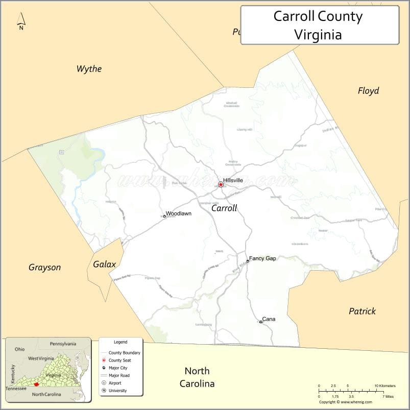
About Carroll County Map, Alabama: The map showing the county boundary, county seat, major cities, highways, water bodies and neighbouring counties.
Related Virginia Links
| Virginia Map | Counties in Virginia | Cities in Virginia |
| Airports in Virginia | Zip Codes in Virginia | Where is Virginia |
| Where is Richmond | Where is Chesapeake | Where is Virginia Beach |
Map of Carroll County, Virginia
Newport News County is a county located in the U.S. state of Virginia. It`s county seat is N/A. As per 2020 census, the population of Newport News County was 184587 and population density of Newport News was square miles. According to the United States Census Bureau, the county has a total area of 68 sq mi (176 km2). Newport News County was established on 1896[12].
Carroll County Facts
| Continent | North America |
| Country | United States |
| State | Virginia |
| County Seat | Hillsville |
| Largest City/Town | Hillsville |
| Established | 1842 |
| Total Area | 478 sq mi (1,238 sq km) |
| Land Area | 475 sq mi (1,230 sq km) |
| Water Area | 3 sq mi (8 sq km) |
| Population | 29,155 (Census 2020) |
| Population Density | 61 people per sq mi |
| Time Zone | Eastern (EST) |
| Major Highways | I-77, US-58, US-221 |
| Major Rivers | New River, Little River |
| Neighboring Counties | Floyd County, Patrick County, Grayson County, Wythe County, Surry County (NC), Alleghany County (NC) |
| Famous For | Blue Ridge Mountains, music heritage, scenic drives |
| Top Attractions | Blue Ridge Parkway, New River Trail, Hillsville Flea Market |
| Official Website | Official Website |
About Carroll County, Virginia
Carroll County is located in the southwestern part of Virginia in the state of the United States, and was established in 1842. The county seat is Hillsville, which is also the largest town. The county lies in the Blue Ridge Highlands and is known for its scenic mountain landscapes, outdoor recreation, and rich Appalachian music heritage.
Cities and Towns in Carroll County, Virginia
| City/Town | Population (Census 2020) | Latitude & Longitude |
|---|---|---|
| Hillsville (county seat) | 2,678 | 36.7657°N, 80.7345°W |
| Galax (partly, independent city) | 6,720 | 36.6612°N, 80.9237°W |
| Fancy Gap (CDP) | 237 | 36.6640°N, 80.6992°W |
| Woodlawn (CDP) | 2,300 | 36.7215°N, 80.8487°W |
| Laurel Fork (CDP) | 200 | 36.6753°N, 80.5128°W |
| Fries (town, nearby region) | 422 | 36.7140°N, 81.0112°W |
| Dugspur (CDP) | 100 | 36.7855°N, 80.5792°W |
| Lambsburg (CDP) | 200 | 36.5754°N, 80.7586°W |
Golf Courses in Carroll County, Virginia
| Golf Course | Location | Latitude & Longitude |
|---|---|---|
| Blue Ridge Country Club | Galax area | 36.6570°N, 80.9300°W |
| Olde Mill Golf Resort (nearby) | Laurel Fork | 36.7000°N, 80.5160°W |
Roads and Highways in Carroll County, Virginia
The county is served by major highways that cross the Blue Ridge region.
- I-77 – major north-south interstate through the county
- US-58 – east-west route across southern Virginia
- US-221 – scenic route connecting mountain communities
Neighboring Counties of Carroll County
- Floyd County (north)
- Patrick County (east)
- Grayson County (west)
- Wythe County (northwest)
- Surry County, North Carolina (south)
- Alleghany County, North Carolina (southwest)
Top Attractions in Carroll County, Virginia
The county offers scenic views and cultural experiences.
- Blue Ridge Parkway – scenic drive with overlooks and hiking trails
- New River Trail State Park – biking and walking trail along the river
- Hillsville Flea Market – large annual event and market
- Galax Old Fiddlers’ Convention – famous music festival
- Devil’s Den Nature Preserve – hiking and wildlife viewing
- Rocky Knob Recreation Area – camping and scenic views
Distance from Carroll County to Nearby Cities
- Hillsville to Galax, VA – 15 mi (24 km)
- Hillsville to Wytheville, VA – 30 mi (48 km)
- Hillsville to Roanoke, VA – 70 mi (113 km)
- Hillsville to Winston-Salem, NC – 80 mi (129 km)
- Hillsville to Charlotte, NC – 140 mi (225 km)
FAQs about Carroll County
Carroll County is located in southwestern Virginia within the Blue Ridge Mountains region.
The population of Carroll County is 29,155 according to the 2020 Census.
The county is known for its scenic mountain landscapes, music heritage, and outdoor recreation.
The main highways include Interstate 77, US-58, and US-221.
Yes, Carroll County has access to golf courses such as Blue Ridge Country Club and nearby resorts.
- Accomack County Map, VA
- Albemarle County Map, VA
- Alleghany County Map, VA
- Amelia County Map, VA
- Amherst County Map, VA
- Appomattox County Map, VA
- Arlington County Map, VA
- Augusta County Map, VA
- Bath County Map, VA
- Bedford County Map, VA
- Bland County Map, VA
- Botetourt County Map, VA
- Brunswick County Map, VA
- Buchanan County Map, VA
- Buckingham County Map, VA
- Campbell County Map, VA
- Caroline County Map, VA
- Carroll County Map, VA
- Charles City County Map, VA
- Charlotte County Map, VA
- Chesterfield County Map, VA
- Clarke County Map, VA
- Craig County Map, VA
- Culpeper County Map, VA
- Cumberland County Map, VA
- Dickenson County Map, VA
- Dinwiddie County Map, VA
- Essex County Map, VA
- Fairfax County Map, VA
- Fauquier County Map, VA
- Floyd County Map, VA
- Fluvanna County Map, VA
- Franklin County Map, VA
- Frederick County Map, VA
- Giles County Map, VA
- Gloucester County Map, VA
- Goochland County Map, VA
- Grayson County Map, VA
- Greene County Map, VA
- Greensville County Map, VA
- Halifax County Map, VA
- Hanover County Map, VA
- Henrico County Map, VA
- Henry County Map, VA
- Highland County Map, VA
- Isle of Wight County Map, VA
- James City County Map, VA
- King and Queen County Map, VA
- King George County Map, VA
- King William County Map, VA
- Lancaster County Map, VA
- Lee County Map, VA
- Loudoun County Map, VA
- Louisa County Map, VA
- Lunenburg County Map, VA
- Madison County Map, VA
- Mathews County Map, VA
- Mecklenburg County Map, VA
- Middlesex County Map, VA
- Montgomery County Map, VA
- Nelson County Map, VA
- New Kent County Map, VA
- Northampton County Map, VA
- Northumberland County Map, VA
- Nottoway County Map, VA
- Orange County Map, VA
- Page County Map, VA
- Patrick County Map, VA
- Pittsylvania County Map, VA
- Powhatan County Map, VA
- Prince Edward County Map, VA
- Prince George County Map, VA
- Prince William County Map, VA
- Pulaski County Map, VA
- Rappahannock County Map, VA
- Richmond County Map, VA
- Roanoke County Map, VA
- Rockbridge County Map, VA
- Rockingham County Map, VA
- Russell County Map, VA
- Scott County Map, VA
- Shenandoah County Map, VA
- Smyth County Map, VA
- Southampton County Map, VA
- Spotsylvania County Map, VA
- Stafford County Map, VA
- Surry County Map, VA
- Sussex County Map, VA
- Tazewell County Map, VA
- Warren County Map, VA
- Washington County Map, VA
- Westmoreland County Map, VA
- Wise County Map, VA
- Wythe County Map, VA
- York County Map, VA
- Alexandria County Map, VA
- Bristol County Map, VA
- Buena Vista County Map, VA
- Charlottesville County Map, VA
- Chesapeake County Map, VA
- Colonial Heights County Map, VA
- Covington County Map, VA
- Danville County Map, VA
- Emporia County Map, VA
- Fairfax County Map, VA
- Falls Church County Map, VA
- Alabama Counties
- Alaska boroughs
- Arizona Counties
- Arkansas Counties
- California County Map
- Colorado Counties
- Connecticut Counties
- Delaware Counties
- Florida County Map
- Georgia County Map
- Hawaii Counties
- Idaho Counties
- Illinois Counties
- Indiana Counties
- Iowa Counties
- Kansas Counties
- Kentucky Counties
- Louisiana Counties
- Maine Counties
- Maryland Counties
- Massachusetts Counties
- Michigan County Map
- Minnesota Counties
- Mississippi Counties
- Missouri Counties
- Montana Counties
- Nebraska Counties
- Nevada Counties
- New York Counties
- New Hampshire Counties
- New Jersey Counties
- New Mexico Counties
- North Carolina Counties
- North Dakota Counties
- Ohio County Map
- Oklahoma Counties
- Oregon Counties
- Pennsylvania Counties
- Rhode Island Counties
- South Carolina Counties
- South Dakota Counties
- Map of Tennessee
- Texas County Map
- Utah Counties
- Vermont Counties
- Virginia Counties
- Washington Counties
- West Virginia Counties
- Wisconsin Counties
- Wyoming Counties