Map of Lee County - Lee County is a county located in the U.S. state of Virginia. Lee County Map showing cities, highways, important places and water bodies. Get Where is Lee County located in the map, major cities in Lee county, population, areas, and places of interest.
Map of Lee County, Virginia
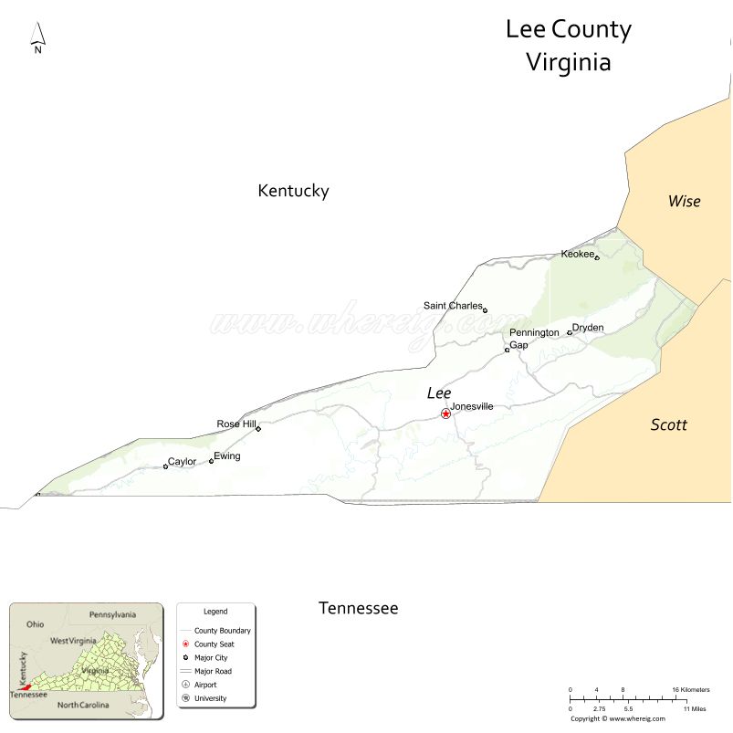
About Lee County Map, Alabama: The map showing the county boundary, county seat, major cities, highways, water bodies and neighbouring counties.
Related Virginia Links
| Virginia Map | Counties in Virginia | Cities in Virginia |
| Airports in Virginia | Zip Codes in Virginia | Where is Virginia |
| Where is Richmond | Where is Chesapeake | Where is Virginia Beach |
Map of Lee County, Virginia
Lincoln County is a county located in the U.S. state of Washington. It`s county seat is Davenport. As per 2020 census, the population of Lincoln County was 10876 and population density of Lincoln was square miles. According to the United States Census Bureau, the county has a total area of 2,311 sq mi (5,985 km2). Lincoln County was established on 1883.
Lee County Facts
| Continent | North America |
| Country | United States |
| State | Virginia |
| County Seat | Jonesville |
| Largest City/Town | Pennington Gap |
| Established | 1792 |
| Total Area | 437 sq mi (1,132 sq km) |
| Land Area | 436 sq mi (1,129 sq km) |
| Water Area | 1 sq mi (3 sq km) |
| Population | 22,173 (Census 2020) |
| Population Density | 51 people per sq mi |
| Time Zone | Eastern (EST) |
| Major Highways | US-58, US-421, US-23 |
| Major Rivers | Powell River, Clinch River |
| Neighboring Counties | Scott County, Wise County, Harlan County (KY), Bell County (KY), Claiborne County (TN), Hancock County (TN) |
| Famous For | Cumberland Gap, natural scenery, Appalachian culture |
| Top Attractions | Cumberland Gap National Historical Park, Wilderness Road State Park, Natural Tunnel State Park (nearby) |
| Official Website | Official Website |
About Lee County, Virginia
Lee County is located in the far southwestern corner of Virginia in the state of the United States, and was established in 1792. The county seat is Jonesville, while Pennington Gap is the largest town. The county lies where Virginia meets Kentucky and Tennessee and is known for its mountainous terrain, historic Cumberland Gap, and strong Appalachian heritage.
Cities and Towns in Lee County, Virginia
| City/Town | Population (Census 2020) | Latitude & Longitude |
|---|---|---|
| Pennington Gap (town) | 1,800 | 36.7600°N, 83.0300°W |
| Jonesville (county seat, town) | 1,000 | 36.6900°N, 83.1100°W |
| St. Charles (town) | 100 | 36.8200°N, 82.9800°W |
| Rose Hill (CDP) | 700 | 36.6700°N, 83.3700°W |
| Ewing (CDP) | 500 | 36.6400°N, 83.4200°W |
| Ben Hur (CDP) | 400 | 36.7500°N, 82.9500°W |
Golf Courses in Lee County, Virginia
| Golf Course | Location | Latitude & Longitude |
|---|---|---|
| No major golf courses within county limits | N/A | N/A |
| Woodlake Golf Club (nearby) | Tazewell area | 37.1000°N, 81.5000°W |
Roads and Highways in Lee County, Virginia
The county is served by highways connecting it to neighboring states and regions.
- US-58 – major east-west route across southern Virginia
- US-421 – connects Virginia to Kentucky and Tennessee
- US-23 – regional north-south route
Neighboring Counties of Lee County
- Wise County (east)
- Scott County (northeast)
- Harlan County, Kentucky (northwest)
- Bell County, Kentucky (west)
- Claiborne County, Tennessee (southwest)
- Hancock County, Tennessee (south)
Top Attractions in Lee County, Virginia
The county offers scenic beauty and historical landmarks.
- Cumberland Gap National Historical Park – historic mountain pass and hiking
- Wilderness Road State Park – frontier history and outdoor activities
- Powell River – fishing and kayaking
- White Rocks – scenic hiking destination
- Natural Tunnel State Park (nearby) – unique geological formation
- Appalachian Mountains – scenic drives and outdoor recreation
Distance from Lee County to Nearby Cities
- Jonesville to Bristol, VA – 65 mi (105 km)
- Jonesville to Knoxville, TN – 85 mi (137 km)
- Jonesville to Roanoke, VA – 200 mi (322 km)
- Jonesville to Lexington, KY – 140 mi (225 km)
- Jonesville to Nashville, TN – 250 mi (402 km)
FAQs about Lee County
Lee County is located in the far southwestern corner of Virginia at the borders of Kentucky and Tennessee.
The population of Lee County is 22,173 according to the 2020 Census.
The county is known for Cumberland Gap, Appalachian culture, and scenic mountain landscapes.
The main highways include US-58, US-421, and US-23.
No major golf courses are located within Lee County, but nearby areas offer golf facilities.
- Accomack County Map, VA
- Albemarle County Map, VA
- Alleghany County Map, VA
- Amelia County Map, VA
- Amherst County Map, VA
- Appomattox County Map, VA
- Arlington County Map, VA
- Augusta County Map, VA
- Bath County Map, VA
- Bedford County Map, VA
- Bland County Map, VA
- Botetourt County Map, VA
- Brunswick County Map, VA
- Buchanan County Map, VA
- Buckingham County Map, VA
- Campbell County Map, VA
- Caroline County Map, VA
- Carroll County Map, VA
- Charles City County Map, VA
- Charlotte County Map, VA
- Chesterfield County Map, VA
- Clarke County Map, VA
- Craig County Map, VA
- Culpeper County Map, VA
- Cumberland County Map, VA
- Dickenson County Map, VA
- Dinwiddie County Map, VA
- Essex County Map, VA
- Fairfax County Map, VA
- Fauquier County Map, VA
- Floyd County Map, VA
- Fluvanna County Map, VA
- Franklin County Map, VA
- Frederick County Map, VA
- Giles County Map, VA
- Gloucester County Map, VA
- Goochland County Map, VA
- Grayson County Map, VA
- Greene County Map, VA
- Greensville County Map, VA
- Halifax County Map, VA
- Hanover County Map, VA
- Henrico County Map, VA
- Henry County Map, VA
- Highland County Map, VA
- Isle of Wight County Map, VA
- James City County Map, VA
- King and Queen County Map, VA
- King George County Map, VA
- King William County Map, VA
- Lancaster County Map, VA
- Lee County Map, VA
- Loudoun County Map, VA
- Louisa County Map, VA
- Lunenburg County Map, VA
- Madison County Map, VA
- Mathews County Map, VA
- Mecklenburg County Map, VA
- Middlesex County Map, VA
- Montgomery County Map, VA
- Nelson County Map, VA
- New Kent County Map, VA
- Northampton County Map, VA
- Northumberland County Map, VA
- Nottoway County Map, VA
- Orange County Map, VA
- Page County Map, VA
- Patrick County Map, VA
- Pittsylvania County Map, VA
- Powhatan County Map, VA
- Prince Edward County Map, VA
- Prince George County Map, VA
- Prince William County Map, VA
- Pulaski County Map, VA
- Rappahannock County Map, VA
- Richmond County Map, VA
- Roanoke County Map, VA
- Rockbridge County Map, VA
- Rockingham County Map, VA
- Russell County Map, VA
- Scott County Map, VA
- Shenandoah County Map, VA
- Smyth County Map, VA
- Southampton County Map, VA
- Spotsylvania County Map, VA
- Stafford County Map, VA
- Surry County Map, VA
- Sussex County Map, VA
- Tazewell County Map, VA
- Warren County Map, VA
- Washington County Map, VA
- Westmoreland County Map, VA
- Wise County Map, VA
- Wythe County Map, VA
- York County Map, VA
- Alexandria County Map, VA
- Bristol County Map, VA
- Buena Vista County Map, VA
- Charlottesville County Map, VA
- Chesapeake County Map, VA
- Colonial Heights County Map, VA
- Covington County Map, VA
- Danville County Map, VA
- Emporia County Map, VA
- Fairfax County Map, VA
- Falls Church County Map, VA
- Alabama Counties
- Alaska boroughs
- Arizona Counties
- Arkansas Counties
- California County Map
- Colorado Counties
- Connecticut Counties
- Delaware Counties
- Florida County Map
- Georgia County Map
- Hawaii Counties
- Idaho Counties
- Illinois Counties
- Indiana Counties
- Iowa Counties
- Kansas Counties
- Kentucky Counties
- Louisiana Counties
- Maine Counties
- Maryland Counties
- Massachusetts Counties
- Michigan County Map
- Minnesota Counties
- Mississippi Counties
- Missouri Counties
- Montana Counties
- Nebraska Counties
- Nevada Counties
- New York Counties
- New Hampshire Counties
- New Jersey Counties
- New Mexico Counties
- North Carolina Counties
- North Dakota Counties
- Ohio County Map
- Oklahoma Counties
- Oregon Counties
- Pennsylvania Counties
- Rhode Island Counties
- South Carolina Counties
- South Dakota Counties
- Map of Tennessee
- Texas County Map
- Utah Counties
- Vermont Counties
- Virginia Counties
- Washington Counties
- West Virginia Counties
- Wisconsin Counties
- Wyoming Counties